![](/images/other/stat-length.png)
![Randonnée Marche Bois-de-Céné - Sentier des cigognes - Photo](https://media.geolcdn.com/t/1900/400/ext.pjpeg?maxdim=2&url=https%3A%2F%2Fstatic1.geolcdn.com%2Fsiteimages%2Fupload%2Ffiles%2F1553511878bg_sport_marche.png)
Sentier des cigognes
neoroll44
Utilisateur
![Longueur](/images/other/stat-length.png)
Longueur
19,8 km
![Altitude max](https://static1.geolcdn.com/siteimages/upload/files/1508320355ic_sort_altitude_max_24dp.png)
Altitude max
33 m
![Dénivelé positif](https://static1.geolcdn.com/siteimages/upload/files/1508320355ic_sort_den_pos_24dp.png)
Dénivelé positif
101 m
![Km-Effort](/images/other/stat-length.png)
Km-Effort
21 km
![Altitude min](https://static1.geolcdn.com/siteimages/upload/files/1508320355ic_sort_altitude_min_24dp.png)
Altitude min
-2 m
![Dénivelé négatif](https://static1.geolcdn.com/siteimages/upload/files/1508320355ic_sort_den_neg_24dp.png)
Dénivelé négatif
103 m
![Boucle](https://static1.geolcdn.com/siteimages/upload/files/16400158638029165_repeat_loop_refresh_sync_direction_icon.png)
Boucle
Oui
Date de création :
2014-12-10 00:00:00.0
Dernière modification :
2014-12-10 00:00:00.0
![Marche](https://static1.geolcdn.com/sitytour/trail-icons/101.png)
5h00
Difficulté : Moyen
![Scannez ce code QR pour ouvrir la randonnée dans l'application SityTrail](https://capi.geolives.com/qq0zvz2zws4bq2lad0pu/sitytour/trails/274849/qr.png?size=200)
Application GPS de randonnée GRATUITE
À propos
Randonnée Marche de 19,8 km à découvrir à Pays de la Loire, Vendée, Bois-de-Céné. Cette randonnée est proposée par neoroll44.
Description
Empruntez les "charrauds", chemins de liaison dans le marais entre Chateauneuf et le Bois de Céné. Balisage: symbole de la cigogne, couleur bleue.
Localisation
Pays :
France
Région :
Pays de la Loire
Département/Province :
Vendée
Commune :
Bois-de-Céné
Localité :
Unknown
Départ:(Dec)
Départ:(UTM)
584762 ; 5198806 (30T) N.
Commentaires
Randonnées à proximité
![Randonnée Marche Châteauneuf - Circuit des cigognes 2 - Photo](https://media.geolcdn.com/t/375/260/ext.jpg?maxdim=2&url=https%3A%2F%2Fstatic1.geolcdn.com%2Fsiteimages%2Fupload%2Ffiles%2F1553511878bg_sport_marche.png)
![Marche Marche](https://static1.geolcdn.com/sitytour/trail-icons/101.png)
Circuit des cigognes 2
Marche
Très difficile
(1)
Châteauneuf,
Pays de la Loire,
Vendée,
France
![](/images/other/stat-length.png)
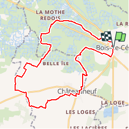
18,8 km | 20 km-effort
4h 34min
![](https://static1.geolcdn.com/siteimages/upload/files/16400158638029165_repeat_loop_refresh_sync_direction_icon.png)
Oui
![Randonnée A pied Châteauneuf - Sentier du Petit Moulin - Photo](https://media.geolcdn.com/t/375/260/ba283f79-af40-47d5-93e6-daf6b2818d81.jpeg&format=jpg&maxdim=2)
![A pied A pied](https://static1.geolcdn.com/sitytour/trail-icons/100.png)
Sentier du Petit Moulin
A pied
Facile
Châteauneuf,
Pays de la Loire,
Vendée,
France
![](/images/other/stat-length.png)
13,2 km | 14,1 km-effort
3h 12min
![](https://static1.geolcdn.com/siteimages/upload/files/16400158638029165_repeat_loop_refresh_sync_direction_icon.png)
Oui
![Randonnée A pied Bois-de-Céné - Sentier des Roseaux - Photo](https://media.geolcdn.com/t/375/260/9019c717-9d69-44c8-8cd2-4e9e08bf3d05.jpeg&format=jpg&maxdim=2)
![A pied A pied](https://static1.geolcdn.com/sitytour/trail-icons/100.png)
Sentier des Roseaux
A pied
Facile
Bois-de-Céné,
Pays de la Loire,
Vendée,
France
![](/images/other/stat-length.png)
8,1 km | 8,4 km-effort
1h 54min
![](https://static1.geolcdn.com/siteimages/upload/files/16400158638029165_repeat_loop_refresh_sync_direction_icon.png)
Oui
![Randonnée Marche Châteauneuf - Sentier du Petit Moulin à Chateauneuf - Photo](https://media.geolcdn.com/t/375/260/ext.jpg?maxdim=2&url=https%3A%2F%2Fstatic1.geolcdn.com%2Fsiteimages%2Fupload%2Ffiles%2F1553511878bg_sport_marche.png)
![Marche Marche](https://static1.geolcdn.com/sitytour/trail-icons/101.png)
Sentier du Petit Moulin à Chateauneuf
Marche
Très facile
(1)
Châteauneuf,
Pays de la Loire,
Vendée,
France
![](/images/other/stat-length.png)
15 km | 16,2 km-effort
Inconnu
![](https://static1.geolcdn.com/siteimages/upload/files/16400158638029165_repeat_loop_refresh_sync_direction_icon.png)
Oui
![Randonnée Marche Bois-de-Céné - 85 - Bois-de -Céné - Photo](https://media.geolcdn.com/t/375/260/ext.jpg?maxdim=2&url=https%3A%2F%2Fstatic1.geolcdn.com%2Fsiteimages%2Fupload%2Ffiles%2F1553511878bg_sport_marche.png)
![Marche Marche](https://static1.geolcdn.com/sitytour/trail-icons/101.png)
85 - Bois-de -Céné
Marche
Facile
Bois-de-Céné,
Pays de la Loire,
Vendée,
France
![](/images/other/stat-length.png)
15,3 km | 15,9 km-effort
4h 50min
![](https://static1.geolcdn.com/siteimages/upload/files/16400158638029165_repeat_loop_refresh_sync_direction_icon.png)
Non
![Randonnée A pied Machecoul-Saint-Même - La Charrau des Tendes - Photo](https://media.geolcdn.com/t/375/260/ext.jpg?maxdim=2&url=https%3A%2F%2Fstatic1.geolcdn.com%2Fsiteimages%2Fupload%2Ffiles%2F1545311037marcheuse_200dpi.jpg)
![A pied A pied](https://static1.geolcdn.com/sitytour/trail-icons/100.png)
La Charrau des Tendes
A pied
Facile
Machecoul-Saint-Même,
Pays de la Loire,
Loire-Atlantique,
France
![](/images/other/stat-length.png)
6,1 km | 6,3 km-effort
1h 25min
![](https://static1.geolcdn.com/siteimages/upload/files/16400158638029165_repeat_loop_refresh_sync_direction_icon.png)
Non
![Randonnée V.T.T. La Garnache - La Garnache 2019 - Photo](https://media.geolcdn.com/t/375/260/ext.jpg?maxdim=2&url=https%3A%2F%2Fstatic1.geolcdn.com%2Fsiteimages%2Fupload%2Ffiles%2F1524743154velo.jpg)
![V.T.T. V.T.T.](https://static1.geolcdn.com/sitytour/trail-icons/202.png)
La Garnache 2019
V.T.T.
Moyen
La Garnache,
Pays de la Loire,
Vendée,
France
![](/images/other/stat-length.png)
40 km | 44 km-effort
2h 51min
![](https://static1.geolcdn.com/siteimages/upload/files/16400158638029165_repeat_loop_refresh_sync_direction_icon.png)
Oui
![Randonnée Randonnée équestre Bois-de-Céné - Bois de Céné: autour de la Bardonnière - Photo](https://media.geolcdn.com/t/375/260/ext.jpg?maxdim=2&url=https%3A%2F%2Fstatic1.geolcdn.com%2Fsiteimages%2Fupload%2Ffiles%2F1524743154cheval.jpg)
![Randonnée équestre Randonnée équestre](https://static1.geolcdn.com/sitytour/trail-icons/301.png)
Bois de Céné: autour de la Bardonnière
Randonnée équestre
Facile
Bois-de-Céné,
Pays de la Loire,
Vendée,
France
![](/images/other/stat-length.png)
6,1 km | 6,7 km-effort
1h 10min
![](https://static1.geolcdn.com/siteimages/upload/files/16400158638029165_repeat_loop_refresh_sync_direction_icon.png)
Oui
![Randonnée Marche Bois-de-Céné - bois de Céné-mon Désir - Photo](https://media.geolcdn.com/t/375/260/ext.jpg?maxdim=2&url=https%3A%2F%2Fstatic1.geolcdn.com%2Fsiteimages%2Fupload%2Ffiles%2F1553511878bg_sport_marche.png)
![Marche Marche](https://static1.geolcdn.com/sitytour/trail-icons/101.png)
bois de Céné-mon Désir
Marche
Moyen
(1)
Bois-de-Céné,
Pays de la Loire,
Vendée,
France
![](/images/other/stat-length.png)
10,9 km | 11,4 km-effort
2h 35min
![](https://static1.geolcdn.com/siteimages/upload/files/16400158638029165_repeat_loop_refresh_sync_direction_icon.png)
Oui