![](/images/other/stat-length.png)
![Randonnée Marche Eaunes - Eaunes lèze fait - Photo](https://media.geolcdn.com/t/1900/400/ext.pjpeg?maxdim=2&url=https%3A%2F%2Fstatic1.geolcdn.com%2Fsiteimages%2Fupload%2Ffiles%2F1553511878bg_sport_marche.png)
Eaunes lèze fait
pidjam
Utilisateur
![Longueur](/images/other/stat-length.png)
Longueur
11,3 km
![Altitude max](https://static1.geolcdn.com/siteimages/upload/files/1508320355ic_sort_altitude_max_24dp.png)
Altitude max
212 m
![Dénivelé positif](https://static1.geolcdn.com/siteimages/upload/files/1508320355ic_sort_den_pos_24dp.png)
Dénivelé positif
83 m
![Km-Effort](/images/other/stat-length.png)
Km-Effort
12,4 km
![Altitude min](https://static1.geolcdn.com/siteimages/upload/files/1508320355ic_sort_altitude_min_24dp.png)
Altitude min
166 m
![Dénivelé négatif](https://static1.geolcdn.com/siteimages/upload/files/1508320355ic_sort_den_neg_24dp.png)
Dénivelé négatif
82 m
![Boucle](https://static1.geolcdn.com/siteimages/upload/files/16400158638029165_repeat_loop_refresh_sync_direction_icon.png)
Boucle
Oui
Date de création :
2021-04-15 11:54:53.28
Dernière modification :
2021-04-16 07:01:32.38
![Marche](https://static1.geolcdn.com/sitytour/trail-icons/101.png)
2h36
Difficulté : Facile
![Scannez ce code QR pour ouvrir la randonnée dans l'application SityTrail](https://capi.geolives.com/qq0zvz2zws4bq2lad0pu/sitytour/trails/2748307/qr.png?size=200)
Application GPS de randonnée GRATUITE
À propos
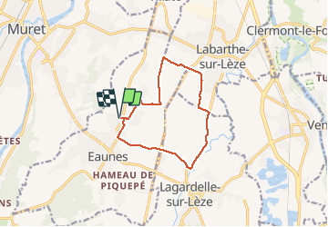
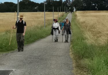
Randonnée Marche de 11,3 km à découvrir à Occitanie, Haute-Garonne, Eaunes. Cette randonnée est proposée par pidjam.
Description
La partie à partir du km 1 est plutôt sauvage (prévoir un sécateur?) mais on peut la remplacer par la route; ça ferait beaucoup de route au total.
Localisation
Pays :
France
Région :
Occitanie
Département/Province :
Haute-Garonne
Commune :
Eaunes
Localité :
Unknown
Départ:(Dec)
Départ:(UTM)
367396 ; 4810484 (31T) N.
Commentaires
Randonnées à proximité
![Randonnée Marche Saubens - Saubens falaise Villate - Photo](https://media.geolcdn.com/t/375/260/ext.jpg?maxdim=2&url=https%3A%2F%2Fservices.sitytrail.com%2FGeolivesWS%2FDownloadMedia.ashx%3FTrailID%3D677857%26Media%3Dfix__20161229150141.jpg)
![Marche Marche](https://static1.geolcdn.com/sitytour/trail-icons/101.png)
Saubens falaise Villate
Marche
Très facile
(3)
Saubens,
Occitanie,
Haute-Garonne,
France
![](/images/other/stat-length.png)
8,9 km | 10 km-effort
2h 11min
![](https://static1.geolcdn.com/siteimages/upload/files/16400158638029165_repeat_loop_refresh_sync_direction_icon.png)
Oui
![Randonnée V.T.T. Muret - Muret, à la sortie du lycée vers la Forêt d'Eaunes - Photo](https://media.geolcdn.com/t/375/260/ext.jpg?maxdim=2&url=https%3A%2F%2Fstatic1.geolcdn.com%2Fsiteimages%2Fupload%2Ffiles%2F1524743154velo.jpg)
![V.T.T. V.T.T.](https://static1.geolcdn.com/sitytour/trail-icons/202.png)
Muret, à la sortie du lycée vers la Forêt d'Eaunes
V.T.T.
Difficile
(2)
Muret,
Occitanie,
Haute-Garonne,
France
![](/images/other/stat-length.png)
24 km | 31 km-effort
2h 30min
![](https://static1.geolcdn.com/siteimages/upload/files/16400158638029165_repeat_loop_refresh_sync_direction_icon.png)
Oui
![Randonnée Marche Muret - Muret - Brioude par GR - Photo](https://media.geolcdn.com/t/375/260/ext.jpg?maxdim=2&url=https%3A%2F%2Fstatic1.geolcdn.com%2Fsiteimages%2Fupload%2Ffiles%2F1553511878bg_sport_marche.png)
![Marche Marche](https://static1.geolcdn.com/sitytour/trail-icons/101.png)
Muret - Brioude par GR
Marche
Moyen
(1)
Muret,
Occitanie,
Haute-Garonne,
France
![](/images/other/stat-length.png)
13,3 km | 15,5 km-effort
3h 0min
![](https://static1.geolcdn.com/siteimages/upload/files/16400158638029165_repeat_loop_refresh_sync_direction_icon.png)
Oui
![Randonnée Marche Muret - Estantens st amans - Photo](https://media.geolcdn.com/t/375/260/ext.jpg?maxdim=2&url=https%3A%2F%2Fservices.sitytrail.com%2FGeolivesWS%2FDownloadMedia.ashx%3FTrailID%3D665045%26Media%3Dfix__20161127152433.jpg)
![Marche Marche](https://static1.geolcdn.com/sitytour/trail-icons/101.png)
Estantens st amans
Marche
Facile
Muret,
Occitanie,
Haute-Garonne,
France
![](/images/other/stat-length.png)
10,3 km | 13,2 km-effort
2h 8min
![](https://static1.geolcdn.com/siteimages/upload/files/16400158638029165_repeat_loop_refresh_sync_direction_icon.png)
Oui
![Randonnée V.T.T. Pins-Justaret - Pins justaret - Photo](https://media.geolcdn.com/t/375/260/ext.jpg?maxdim=2&url=https%3A%2F%2Fstatic1.geolcdn.com%2Fsiteimages%2Fupload%2Ffiles%2F1524743154velo.jpg)
![V.T.T. V.T.T.](https://static1.geolcdn.com/sitytour/trail-icons/202.png)
Pins justaret
V.T.T.
Facile
(1)
Pins-Justaret,
Occitanie,
Haute-Garonne,
France
![](/images/other/stat-length.png)
34 km | 40 km-effort
2h 49min
![](https://static1.geolcdn.com/siteimages/upload/files/16400158638029165_repeat_loop_refresh_sync_direction_icon.png)
Oui
![Randonnée Marche Saubens - Saubens JP - Photo](https://media.geolcdn.com/t/375/260/cb358ee6-4cef-423d-9edf-355df76ce1bd.jpg&format=jpg&maxdim=2)
![Marche Marche](https://static1.geolcdn.com/sitytour/trail-icons/101.png)
Saubens JP
Marche
Difficile
Saubens,
Occitanie,
Haute-Garonne,
France
![](/images/other/stat-length.png)
10,5 km | 12,3 km-effort
2h 19min
![](https://static1.geolcdn.com/siteimages/upload/files/16400158638029165_repeat_loop_refresh_sync_direction_icon.png)
Oui
![Randonnée Marche Muret - muret ferrane JP - Photo](https://media.geolcdn.com/t/375/260/903e7717-ef53-4818-9bc8-a39c454bf6a2.jpg&format=jpg&maxdim=2)
![Marche Marche](https://static1.geolcdn.com/sitytour/trail-icons/101.png)
muret ferrane JP
Marche
Difficile
Muret,
Occitanie,
Haute-Garonne,
France
![](/images/other/stat-length.png)
9,7 km | 12,1 km-effort
2h 48min
![](https://static1.geolcdn.com/siteimages/upload/files/16400158638029165_repeat_loop_refresh_sync_direction_icon.png)
Oui
![Randonnée Marche Muret - Amans JP un - Photo](https://media.geolcdn.com/t/375/260/7cbd2bc8-f7bc-47e8-944d-6888076eb90d.jpg&format=jpg&maxdim=2)
![Marche Marche](https://static1.geolcdn.com/sitytour/trail-icons/101.png)
Amans JP un
Marche
Difficile
Muret,
Occitanie,
Haute-Garonne,
France
![](/images/other/stat-length.png)
9,1 km | 12 km-effort
2h 33min
![](https://static1.geolcdn.com/siteimages/upload/files/16400158638029165_repeat_loop_refresh_sync_direction_icon.png)
Oui
![Randonnée Marche Eaunes - EAUNES-CHAPELLE ST AMANS en boucle - Photo](https://media.geolcdn.com/t/375/260/002e25a3-4cc6-418b-b5fc-60208da3069d.jpg&format=jpg&maxdim=2)
![Marche Marche](https://static1.geolcdn.com/sitytour/trail-icons/101.png)
EAUNES-CHAPELLE ST AMANS en boucle
Marche
Facile
Eaunes,
Occitanie,
Haute-Garonne,
France
![](/images/other/stat-length.png)
10,9 km | 14,3 km-effort
2h 49min
![](https://static1.geolcdn.com/siteimages/upload/files/16400158638029165_repeat_loop_refresh_sync_direction_icon.png)
Oui