![](/images/other/stat-length.png)
![Randonnée Marche Chamonix-Mont-Blanc - Chamonix...Bob. G... Planpraz Brévent et retour Planpraz.. - Photo](https://media.geolcdn.com/t/1900/400/ext.pjpeg?maxdim=2&url=https%3A%2F%2Fstatic1.geolcdn.com%2Fsiteimages%2Fupload%2Ffiles%2F1553511878bg_sport_marche.png)
Chamonix...Bob. G... Planpraz Brévent et retour Planpraz..
r.genette
Utilisateur
![Longueur](/images/other/stat-length.png)
Longueur
6,7 km
![Altitude max](https://static1.geolcdn.com/siteimages/upload/files/1508320355ic_sort_altitude_max_24dp.png)
Altitude max
2508 m
![Dénivelé positif](https://static1.geolcdn.com/siteimages/upload/files/1508320355ic_sort_den_pos_24dp.png)
Dénivelé positif
672 m
![Km-Effort](/images/other/stat-length.png)
Km-Effort
15,7 km
![Altitude min](https://static1.geolcdn.com/siteimages/upload/files/1508320355ic_sort_altitude_min_24dp.png)
Altitude min
2005 m
![Dénivelé négatif](https://static1.geolcdn.com/siteimages/upload/files/1508320355ic_sort_den_neg_24dp.png)
Dénivelé négatif
674 m
![Boucle](https://static1.geolcdn.com/siteimages/upload/files/16400158638029165_repeat_loop_refresh_sync_direction_icon.png)
Boucle
Oui
Date de création :
2014-12-10 00:00:00.0
Dernière modification :
2014-12-10 00:00:00.0
![Marche](https://static1.geolcdn.com/sitytour/trail-icons/101.png)
3h00
Difficulté : Moyen
![Scannez ce code QR pour ouvrir la randonnée dans l'application SityTrail](https://capi.geolives.com/qq0zvz2zws4bq2lad0pu/sitytour/trails/274784/qr.png?size=200)
Application GPS de randonnée GRATUITE
À propos
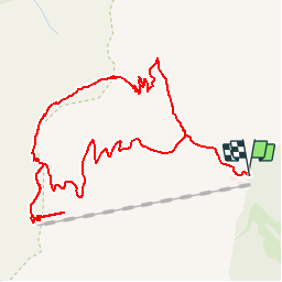
Randonnée Marche de 6,7 km à découvrir à Auvergne-Rhône-Alpes, Haute-Savoie, Chamonix-Mont-Blanc. Cette randonnée est proposée par r.genette.
Description
Départ de Planpraz, grimpette jusqu'au Brévent par la piste de ski et retour Planpraz par l'arrière du Brévent en suivant le GR5.
Localisation
Pays :
France
Région :
Auvergne-Rhône-Alpes
Département/Province :
Haute-Savoie
Commune :
Chamonix-Mont-Blanc
Localité :
Unknown
Départ:(Dec)
Départ:(UTM)
333623 ; 5089183 (32T) N.
Commentaires
Randonnées à proximité
![Randonnée Marche Chamonix-Mont-Blanc - J8 - Cascade du Dard - Photo](https://media.geolcdn.com/t/375/260/c145d485-4f6a-4304-96f9-70fb8a7d1c29.jpg&format=jpg&maxdim=2)
![Marche Marche](https://static1.geolcdn.com/sitytour/trail-icons/101.png)
J8 - Cascade du Dard
Marche
Moyen
(1)
Chamonix-Mont-Blanc,
Auvergne-Rhône-Alpes,
Haute-Savoie,
France
![](/images/other/stat-length.png)
6,1 km | 9,4 km-effort
1h 45min
![](https://static1.geolcdn.com/siteimages/upload/files/16400158638029165_repeat_loop_refresh_sync_direction_icon.png)
Oui
![Randonnée Marche Les Houches - La Statue du Christ-Roi. - Photo](https://media.geolcdn.com/t/375/260/5a9858e2-48aa-4c94-bd12-4c66dc77167c.jpg&format=jpg&maxdim=2)
![Marche Marche](https://static1.geolcdn.com/sitytour/trail-icons/101.png)
La Statue du Christ-Roi.
Marche
Facile
(1)
Les Houches,
Auvergne-Rhône-Alpes,
Haute-Savoie,
France
![](/images/other/stat-length.png)
1,8 km | 4,2 km-effort
56min
![](https://static1.geolcdn.com/siteimages/upload/files/16400158638029165_repeat_loop_refresh_sync_direction_icon.png)
Non
![Randonnée Course à pied Chamonix-Mont-Blanc - The North Face© Ultra Trail du Mont-Blanc© UTMB 2008 - Photo](https://media.geolcdn.com/t/375/260/ext.jpg?maxdim=2&url=https%3A%2F%2Fservices.sitytrail.com%2FGeolivesWS%2FDownloadMedia.ashx%3FTrailID%3D109134%26Media%3D3174_5.jpg)
![Course à pied Course à pied](https://static1.geolcdn.com/sitytour/trail-icons/103.png)
The North Face© Ultra Trail du Mont-Blanc© UTMB 2008
Course à pied
Très difficile
(2)
Chamonix-Mont-Blanc,
Auvergne-Rhône-Alpes,
Haute-Savoie,
France
![](/images/other/stat-length.png)
160 km | 288 km-effort
46h 0min
![](https://static1.geolcdn.com/siteimages/upload/files/16400158638029165_repeat_loop_refresh_sync_direction_icon.png)
Oui
![Randonnée Marche Chamonix-Mont-Blanc - Circuit de la Mer de Glace - Chamonix Mont Blanc - Photo](https://media.geolcdn.com/t/375/260/ext.jpg?maxdim=2&url=https%3A%2F%2Fservices.sitytrail.com%2FGeolivesWS%2FDownloadMedia.ashx%3FTrailID%3D103700%26Media%3D6192_6.jpg)
![Marche Marche](https://static1.geolcdn.com/sitytour/trail-icons/101.png)
Circuit de la Mer de Glace - Chamonix Mont Blanc
Marche
Difficile
(2)
Chamonix-Mont-Blanc,
Auvergne-Rhône-Alpes,
Haute-Savoie,
France
![](/images/other/stat-length.png)
13,3 km | 24 km-effort
5h 30min
![](https://static1.geolcdn.com/siteimages/upload/files/16400158638029165_repeat_loop_refresh_sync_direction_icon.png)
Oui
![Randonnée Marche Chamonix-Mont-Blanc - Glacier des Bossons Les Houches Chamonix - Photo](https://media.geolcdn.com/t/375/260/ext.jpg?maxdim=2&url=https%3A%2F%2Fservices.sitytrail.com%2FGeolivesWS%2FDownloadMedia.ashx%3FTrailID%3D118854%26Media%3D13070_2.jpg)
![Marche Marche](https://static1.geolcdn.com/sitytour/trail-icons/101.png)
Glacier des Bossons Les Houches Chamonix
Marche
Difficile
(2)
Chamonix-Mont-Blanc,
Auvergne-Rhône-Alpes,
Haute-Savoie,
France
![](/images/other/stat-length.png)
13,1 km | 28 km-effort
5h 0min
![](https://static1.geolcdn.com/siteimages/upload/files/16400158638029165_repeat_loop_refresh_sync_direction_icon.png)
Oui
![Randonnée Marche Chamonix-Mont-Blanc - Chalet des Pyramides 1895m 11.7.22 - Photo](https://media.geolcdn.com/t/375/260/ef1bf2d0-a858-40af-bcf2-b4e7d382c27f.jpg&format=jpg&maxdim=2)
![Marche Marche](https://static1.geolcdn.com/sitytour/trail-icons/101.png)
Chalet des Pyramides 1895m 11.7.22
Marche
Moyen
Chamonix-Mont-Blanc,
Auvergne-Rhône-Alpes,
Haute-Savoie,
France
![](/images/other/stat-length.png)
7,7 km | 15,2 km-effort
3h 30min
![](https://static1.geolcdn.com/siteimages/upload/files/16400158638029165_repeat_loop_refresh_sync_direction_icon.png)
Oui
![Randonnée Course à pied Chamonix-Mont-Blanc - Hôtel Arveyron au Chalet de la Floria - Photo](https://media.geolcdn.com/t/375/260/ext.jpg?maxdim=2&url=https%3A%2F%2Fstatic1.geolcdn.com%2Fsiteimages%2Fupload%2Ffiles%2F1524743154running.jpg)
![Course à pied Course à pied](https://static1.geolcdn.com/sitytour/trail-icons/103.png)
Hôtel Arveyron au Chalet de la Floria
Course à pied
Moyen
(1)
Chamonix-Mont-Blanc,
Auvergne-Rhône-Alpes,
Haute-Savoie,
France
![](/images/other/stat-length.png)
10,4 km | 15,5 km-effort
1h 28min
![](https://static1.geolcdn.com/siteimages/upload/files/16400158638029165_repeat_loop_refresh_sync_direction_icon.png)
Oui
![Randonnée Marche Chamonix-Mont-Blanc - La cascade du dard - Photo](https://media.geolcdn.com/t/375/260/ext.jpg?maxdim=2&url=https%3A%2F%2Fservices.sitytrail.com%2FGeolivesWS%2FDownloadMedia.ashx%3FTrailID%3D626685%26Media%3D433ceacd-297f-461a-afa3-69d034da6405.jpg)
![Marche Marche](https://static1.geolcdn.com/sitytour/trail-icons/101.png)
La cascade du dard
Marche
Moyen
Chamonix-Mont-Blanc,
Auvergne-Rhône-Alpes,
Haute-Savoie,
France
![](/images/other/stat-length.png)
8,2 km | 13,6 km-effort
2h 0min
![](https://static1.geolcdn.com/siteimages/upload/files/16400158638029165_repeat_loop_refresh_sync_direction_icon.png)
Oui
![Randonnée Marche Chamonix-Mont-Blanc - Le lac bleus - Photo](https://media.geolcdn.com/t/375/260/ext.jpg?maxdim=2&url=https%3A%2F%2Fservices.sitytrail.com%2FGeolivesWS%2FDownloadMedia.ashx%3FTrailID%3D467938%26Media%3D0e0140a2-6104-42dc-addc-29be79b70aa4.jpg)
![Marche Marche](https://static1.geolcdn.com/sitytour/trail-icons/101.png)
Le lac bleus
Marche
Moyen
Chamonix-Mont-Blanc,
Auvergne-Rhône-Alpes,
Haute-Savoie,
France
![](/images/other/stat-length.png)
17,1 km | 35 km-effort
6h 57min
![](https://static1.geolcdn.com/siteimages/upload/files/16400158638029165_repeat_loop_refresh_sync_direction_icon.png)
Oui