Randonnée Marche Ammerschwihr - Entre vergers et vignes de Sigolsheim  - Photo

Entre vergers et vignes de Sigolsheim

 zazie
zazie

Utilisateur

© OpenStreetMap contributors
Longueur
Longueur
8,5 km
Altitude max
Altitude max
222 m
Dénivelé positif
Dénivelé positif
58 m
Km-Effort
Km-Effort  
9,3 km
Altitude min
Altitude min
193 m
Dénivelé négatif
Dénivelé négatif
57 m
Boucle
Boucle
Oui
Date de création :
2021-04-13 12:04:03.981
Dernière modification :
2021-04-13 13:46:59.752

(1 Avis)

Marche
Marche
1h36
Difficulté : Très facile
V.T.C.
V.T.C.
1h00
Difficulté : Facile

Scannez ce code QR pour ouvrir la randonnée dans l'application SityTrail

Application GPS de randonnée GRATUITE

Logo SityTrail SityTrail

IGN / Instituts géographiques

Télécharger SityTrail sur l'App Store Télécharger SityTrail sur Google Play

Logo SityTrail SityTrail World

Le monde est à vous

Télécharger SityTrail sur l'App Store Télécharger SityTrail sur Google Play Télécharger SityTrail sur Huawei AppGallery

À propos

Randonnée Marche de 8,5 km à découvrir à Grand Est, Haut-Rhin, Ammerschwihr. Cette randonnée est proposée par zazie.

Description

Promenade en vélo envisageable

Profil altimétrique

Photos

Localisation

Pays :
France
Région :
Grand Est
Département/Province :
Haut-Rhin
Commune :
Ammerschwihr
Localité :
Unknown
Départ:(UTM)
374426 ; 5331586 (32U) N.

Commentaires

Veuillez vous connecter pour laisser un commentaire ou une note


Randonnées à proximité

Randonnée Marche Ammerschwihr - D'Ammerschwihr aux Trois Epis - Photo
Marche
VacheKiri67

Marche

Difficile
(1)
Ammerschwihr, Grand Est, Haut-Rhin, France
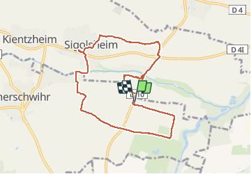
17,1 km | 25 km-effort
5h 35min
Oui
Randonnée Marche Kaysersberg-Vignoble - Du ⛺️ aux 4 villages - Photo
Marche
GUIDE
mumu.larandonneuse

Marche

Moyen
Kaysersberg-Vignoble, Grand Est, Haut-Rhin, France
12,9 km | 15,1 km-effort
3h 30min
Oui
Randonnée Marche Kaysersberg-Vignoble - 2021-05-30 Marche Kaysersberg Ursprung St Alexis - Photo
Marche
GUIDE
holtzv

Marche

Très difficile
Kaysersberg-Vignoble, Grand Est, Haut-Rhin, France
17,1 km | 26 km-effort
4h 46min
Oui
Randonnée Course à pied Colmar - Covid-19 - A la recherche du cercle parfait - Photo
Course à pied
zazie

Course à pied

Très facile
(1)
Colmar, Grand Est, Haut-Rhin, France
11,2 km | 11,9 km-effort
1h 0min
Oui
Randonnée Randonnée équestre Kaysersberg-Vignoble - 2019-10-26 CDTE67 Tournage Video Promotion TE - Photo
Randonnée équestre
GUIDE
holtzv

Randonnée équestre

Facile
Kaysersberg-Vignoble, Grand Est, Haut-Rhin, France
24 km | 29 km-effort
24min
Non
Randonnée Randonnée équestre Kaysersberg-Vignoble - 2019-06-09 Journee Sigolsheim boucle - Photo
Randonnée équestre
GUIDE
holtzv

Randonnée équestre

Très difficile
Kaysersberg-Vignoble, Grand Est, Haut-Rhin, France
32 km | 45 km-effort
5h 55min
Oui
Randonnée Marche Riquewihr - Sentier des grands crus - Photo
Marche
GUIDE
pascalou73

Marche

Moyen
(2)
Riquewihr, Grand Est, Haut-Rhin, France
11,5 km | 14,4 km-effort
3h 7min
Oui
Randonnée Marche Kaysersberg-Vignoble - Le tour de Kysersberg - Photo
Marche
GUIDE
pascalou73

Marche

Moyen
(1)
Kaysersberg-Vignoble, Grand Est, Haut-Rhin, France
7,9 km | 11,7 km-effort
2h 34min
Oui
Randonnée Marche Colmar - grand tour de Colmar - Photo
Marche
Domdomii

Marche

Très facile
(1)
Colmar, Grand Est, Haut-Rhin, France
4,7 km | 5,1 km-effort
1h 22min
Oui


Fermer
Mes abonnements