![](/images/other/stat-length.png)
![Randonnée Marche Sainte-Agnès - Cime de Baudon depuis St Agnès - Photo](https://media.geolcdn.com/t/1900/400/ext.pjpeg?maxdim=2&url=https%3A%2F%2Fservices.sitytrail.com%2FGeolivesWS%2FDownloadMedia.ashx%3FTrailID%3D273927%26Media%3Dfix__20140504161441.jpg)
Cime de Baudon depuis St Agnès
boboazur
Utilisateur
![Longueur](/images/other/stat-length.png)
Longueur
8,8 km
![Altitude max](https://static1.geolcdn.com/siteimages/upload/files/1508320355ic_sort_altitude_max_24dp.png)
Altitude max
1231 m
![Dénivelé positif](https://static1.geolcdn.com/siteimages/upload/files/1508320355ic_sort_den_pos_24dp.png)
Dénivelé positif
648 m
![Km-Effort](/images/other/stat-length.png)
Km-Effort
17,5 km
![Altitude min](https://static1.geolcdn.com/siteimages/upload/files/1508320355ic_sort_altitude_min_24dp.png)
Altitude min
586 m
![Dénivelé négatif](https://static1.geolcdn.com/siteimages/upload/files/1508320355ic_sort_den_neg_24dp.png)
Dénivelé négatif
648 m
![Boucle](https://static1.geolcdn.com/siteimages/upload/files/16400158638029165_repeat_loop_refresh_sync_direction_icon.png)
Boucle
Oui
Date de création :
2014-12-10 00:00:00.0
Dernière modification :
2014-12-10 00:00:00.0
![Marche](https://static1.geolcdn.com/sitytour/trail-icons/101.png)
4h46
Difficulté : Moyen
![Scannez ce code QR pour ouvrir la randonnée dans l'application SityTrail](https://capi.geolives.com/qq0zvz2zws4bq2lad0pu/sitytour/trails/273927/qr.png?size=200)
Application GPS de randonnée GRATUITE
À propos
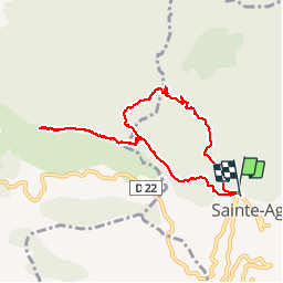
Randonnée Marche de 8,8 km à découvrir à Provence-Alpes-Côte d'Azur, Alpes-Maritimes, Sainte-Agnès. Cette randonnée est proposée par boboazur.
Description
Boucle au départ du village perché de St Agnès en direction de la cime de Baudon. Au sommet très belle vue mer et cimes du Mercantour à 360°. Table d'orientation au sommet.
Localisation
Pays :
France
Région :
Provence-Alpes-Côte d'Azur
Département/Province :
Alpes-Maritimes
Commune :
Sainte-Agnès
Localité :
Unknown
Départ:(Dec)
Départ:(UTM)
375984 ; 4851087 (32T) N.
Commentaires
Randonnées à proximité
![Randonnée Marche Castellar - Mont Carpano en boucle - Photo](https://media.geolcdn.com/t/375/260/ext.jpg?maxdim=2&url=https%3A%2F%2Fservices.sitytrail.com%2FGeolivesWS%2FDownloadMedia.ashx%3FTrailID%3D232983%26Media%3Dfix__20131116134859.jpg)
![Marche Marche](https://static1.geolcdn.com/sitytour/trail-icons/101.png)
Mont Carpano en boucle
Marche
Moyen
(1)
Castellar,
Provence-Alpes-Côte d'Azur,
Alpes-Maritimes,
France
![](/images/other/stat-length.png)
8,1 km | 14,4 km-effort
3h 18min
![](https://static1.geolcdn.com/siteimages/upload/files/16400158638029165_repeat_loop_refresh_sync_direction_icon.png)
Oui
![Randonnée Marche Castellar - Castellar Gramondo Bocca Bassa Col St Bernard Monti réel - Photo](https://media.geolcdn.com/t/375/260/9ef1219a-4e40-4498-97fc-47b72eb8b3af.jpg&format=jpg&maxdim=2)
![Marche Marche](https://static1.geolcdn.com/sitytour/trail-icons/101.png)
Castellar Gramondo Bocca Bassa Col St Bernard Monti réel
Marche
Très difficile
Castellar,
Provence-Alpes-Côte d'Azur,
Alpes-Maritimes,
France
![](/images/other/stat-length.png)
18,1 km | 36 km-effort
8h 17min
![](https://static1.geolcdn.com/siteimages/upload/files/16400158638029165_repeat_loop_refresh_sync_direction_icon.png)
Oui
![Randonnée A pied Peille - Cime de Baudon - Photo](https://media.geolcdn.com/t/375/260/9fe230af-c31e-48d2-a797-a81c449946d4.jpeg&format=jpg&maxdim=2)
![A pied A pied](https://static1.geolcdn.com/sitytour/trail-icons/100.png)
Cime de Baudon
A pied
Facile
Peille,
Provence-Alpes-Côte d'Azur,
Alpes-Maritimes,
France
![](/images/other/stat-length.png)
7 km | 14,7 km-effort
3h 20min
![](https://static1.geolcdn.com/siteimages/upload/files/16400158638029165_repeat_loop_refresh_sync_direction_icon.png)
Oui
![Randonnée A pied Vintimille - AM0 - ALPI MARE 0 - Photo](https://media.geolcdn.com/t/375/260/6cc1eb13-113d-4d04-9dbb-12c9f2aaa749.jpeg&format=jpg&maxdim=2)
![A pied A pied](https://static1.geolcdn.com/sitytour/trail-icons/100.png)
AM0 - ALPI MARE 0
A pied
Facile
Vintimille,
Ligurie,
Imperia,
Italie
![](/images/other/stat-length.png)
9,7 km | 13,8 km-effort
3h 8min
![](https://static1.geolcdn.com/siteimages/upload/files/16400158638029165_repeat_loop_refresh_sync_direction_icon.png)
Non
![Randonnée Marche Gorbio - Gorbio-Circuit des Cabanelles 31-10-2016 - Photo](https://media.geolcdn.com/t/375/260/ext.jpg?maxdim=2&url=https%3A%2F%2Fstatic1.geolcdn.com%2Fsiteimages%2Fupload%2Ffiles%2F1553511878bg_sport_marche.png)
![Marche Marche](https://static1.geolcdn.com/sitytour/trail-icons/101.png)
Gorbio-Circuit des Cabanelles 31-10-2016
Marche
Moyen
(1)
Gorbio,
Provence-Alpes-Côte d'Azur,
Alpes-Maritimes,
France
![](/images/other/stat-length.png)
10,8 km | 21 km-effort
3h 51min
![](https://static1.geolcdn.com/siteimages/upload/files/16400158638029165_repeat_loop_refresh_sync_direction_icon.png)
Oui
![Randonnée Marche Peille - Cime de Baudon - Photo](https://media.geolcdn.com/t/375/260/ext.jpg?maxdim=2&url=https%3A%2F%2Fstatic1.geolcdn.com%2Fsiteimages%2Fupload%2Ffiles%2F1553511878bg_sport_marche.png)
![Marche Marche](https://static1.geolcdn.com/sitytour/trail-icons/101.png)
Cime de Baudon
Marche
Moyen
(1)
Peille,
Provence-Alpes-Côte d'Azur,
Alpes-Maritimes,
France
![](/images/other/stat-length.png)
7,8 km | 15,7 km-effort
4h 15min
![](https://static1.geolcdn.com/siteimages/upload/files/16400158638029165_repeat_loop_refresh_sync_direction_icon.png)
Oui
![Randonnée Marche Castellar - mont carpano au départ de Castellar - Photo](https://media.geolcdn.com/t/375/260/2bb0ee4e-7242-4d27-af93-c9590a3b2d34.jpg&format=jpg&maxdim=2)
![Marche Marche](https://static1.geolcdn.com/sitytour/trail-icons/101.png)
mont carpano au départ de Castellar
Marche
Moyen
(1)
Castellar,
Provence-Alpes-Côte d'Azur,
Alpes-Maritimes,
France
![](/images/other/stat-length.png)
7,7 km | 13,9 km-effort
5h 14min
![](https://static1.geolcdn.com/siteimages/upload/files/16400158638029165_repeat_loop_refresh_sync_direction_icon.png)
Oui
![Randonnée Marche Castellar - Castellane - roc d'Ormea - Photo](https://media.geolcdn.com/t/375/260/d39ef450-7508-4f50-ab04-0e63a1f225c7.jpg&format=jpg&maxdim=2)
![Marche Marche](https://static1.geolcdn.com/sitytour/trail-icons/101.png)
Castellane - roc d'Ormea
Marche
Moyen
Castellar,
Provence-Alpes-Côte d'Azur,
Alpes-Maritimes,
France
![](/images/other/stat-length.png)
9,7 km | 20 km-effort
3h 26min
![](https://static1.geolcdn.com/siteimages/upload/files/16400158638029165_repeat_loop_refresh_sync_direction_icon.png)
Non
![Randonnée Marche Castillon - Castillon : Mt Ours - Photo](https://media.geolcdn.com/t/375/260/18e786f6-adf4-41b3-a67d-83ef4f1666ea.jpg&format=jpg&maxdim=2)
![Marche Marche](https://static1.geolcdn.com/sitytour/trail-icons/101.png)
Castillon : Mt Ours
Marche
Moyen
Castillon,
Provence-Alpes-Côte d'Azur,
Alpes-Maritimes,
France
![](/images/other/stat-length.png)
16,7 km | 29 km-effort
4h 22min
![](https://static1.geolcdn.com/siteimages/upload/files/16400158638029165_repeat_loop_refresh_sync_direction_icon.png)
Oui
Nice