![](/images/other/stat-length.png)
![Randonnée A pied Belvédère - Lac des Merveilles par Pas de l'Arpette - Photo](https://media.geolcdn.com/t/1900/400/ext.pjpeg?maxdim=2&url=https%3A%2F%2Fstatic1.geolcdn.com%2Fsiteimages%2Fupload%2Ffiles%2F1545311037marcheuse_200dpi.jpg)
Lac des Merveilles par Pas de l'Arpette
toutankhcarton
Utilisateur GUIDE
![Longueur](/images/other/stat-length.png)
![Altitude max](https://static1.geolcdn.com/siteimages/upload/files/1508320355ic_sort_altitude_max_24dp.png)
![Dénivelé positif](https://static1.geolcdn.com/siteimages/upload/files/1508320355ic_sort_den_pos_24dp.png)
![Km-Effort](/images/other/stat-length.png)
![Altitude min](https://static1.geolcdn.com/siteimages/upload/files/1508320355ic_sort_altitude_min_24dp.png)
![Dénivelé négatif](https://static1.geolcdn.com/siteimages/upload/files/1508320355ic_sort_den_neg_24dp.png)
![Boucle](https://static1.geolcdn.com/siteimages/upload/files/16400158638029165_repeat_loop_refresh_sync_direction_icon.png)
![A pied](https://static1.geolcdn.com/sitytour/trail-icons/100.png)
3h37
Difficulté : Facile
![Scannez ce code QR pour ouvrir la randonnée dans l'application SityTrail](https://capi.geolives.com/qq0zvz2zws4bq2lad0pu/sitytour/trails/2732395/qr.png?size=200)
Application GPS de randonnée GRATUITE
À propos
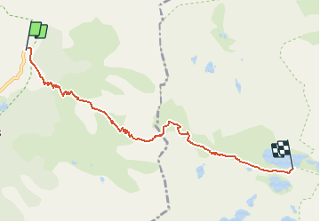
Randonnée A pied de 6,5 km à découvrir à Provence-Alpes-Côte d'Azur, Alpes-Maritimes, Belvédère. Cette randonnée est proposée par toutankhcarton.
Description
Départ parking du Countet.
Traverser le Pont du Countet, prendre le sentier à droite et rejoindre la balise 412.
Remonter le vallon d'Empuonrame jusqu'au Pas de l'Arpette (2511m)et descendre jusqu'au refuge des Merveilles (2130m)en passant par les balises 93 et 92.
Retour par le même itinéraire.
Belle vue depuis le Pas de l'Arpette. Lac long supérieur, Lacs Saorgine, Fourca, du Trem, de la Muta
Localisation
Commentaires
Randonnées à proximité
![Randonnée A pied Saint-Martin-Vésubie - Lacs de Prals - Photo](https://media.geolcdn.com/t/375/260/ext.jpg?maxdim=2&url=https%3A%2F%2Fstatic1.geolcdn.com%2Fsiteimages%2Fupload%2Ffiles%2F1545311037marcheuse_200dpi.jpg)
![A pied A pied](https://static1.geolcdn.com/sitytour/trail-icons/100.png)
A pied
![](/images/other/stat-length.png)
![](https://static1.geolcdn.com/siteimages/upload/files/16400158638029165_repeat_loop_refresh_sync_direction_icon.png)
![Randonnée Marche Saint-Martin-Vésubie - Boucle Les lacs de Prals par la cime de la Vallette - Photo](https://media.geolcdn.com/t/375/260/2c298eac-1e8e-4f8d-83e4-c08337da9759.jpg&format=jpg&maxdim=2)
![Marche Marche](https://static1.geolcdn.com/sitytour/trail-icons/101.png)
Marche
![](/images/other/stat-length.png)
![](https://static1.geolcdn.com/siteimages/upload/files/16400158638029165_repeat_loop_refresh_sync_direction_icon.png)
![Randonnée A pied Tende - Tour du Grand Capelet - Etape 3 - Photo](https://media.geolcdn.com/t/375/260/67c778a0-1b6d-4c3c-80c3-0c64750da270.jpeg&format=jpg&maxdim=2)
![A pied A pied](https://static1.geolcdn.com/sitytour/trail-icons/100.png)
A pied
![](/images/other/stat-length.png)
![](https://static1.geolcdn.com/siteimages/upload/files/16400158638029165_repeat_loop_refresh_sync_direction_icon.png)
![Randonnée A pied Belvédère - Les Merveilles par la Gordolasque - Photo](https://media.geolcdn.com/t/375/260/530d04a7-b615-4962-acf5-9f79fcad8eda.jpeg&format=jpg&maxdim=2)
![A pied A pied](https://static1.geolcdn.com/sitytour/trail-icons/100.png)
A pied
![](/images/other/stat-length.png)
![](https://static1.geolcdn.com/siteimages/upload/files/16400158638029165_repeat_loop_refresh_sync_direction_icon.png)
![Randonnée A pied Saint-Martin-Vésubie - Circuit de Fenestre - Photo](https://media.geolcdn.com/t/375/260/2f55aaab-545e-409a-9c6e-8c2e9c42d8aa.jpeg&format=jpg&maxdim=2)
![A pied A pied](https://static1.geolcdn.com/sitytour/trail-icons/100.png)
A pied
![](/images/other/stat-length.png)
![](https://static1.geolcdn.com/siteimages/upload/files/16400158638029165_repeat_loop_refresh_sync_direction_icon.png)
![Marche Marche](https://static1.geolcdn.com/sitytour/trail-icons/101.png)
Marche
![](/images/other/stat-length.png)
![](https://static1.geolcdn.com/siteimages/upload/files/16400158638029165_repeat_loop_refresh_sync_direction_icon.png)
![Randonnée Marche Belvédère - Refuge de Nice le Lac Autier - Photo](https://media.geolcdn.com/t/375/260/90f5472c-c83a-4f85-b43b-3f70801c497f.jpg&format=jpg&maxdim=2)
![Marche Marche](https://static1.geolcdn.com/sitytour/trail-icons/101.png)
Marche
![](/images/other/stat-length.png)
![](https://static1.geolcdn.com/siteimages/upload/files/16400158638029165_repeat_loop_refresh_sync_direction_icon.png)
![Randonnée Marche Belvédère - Pont du Countet refuge de Nice et Lacs du Mont Clapier - Photo](https://media.geolcdn.com/t/375/260/e630815b-37c0-4f3c-a885-04147e40707a.jpg&format=jpg&maxdim=2)
![Marche Marche](https://static1.geolcdn.com/sitytour/trail-icons/101.png)
Marche
![](/images/other/stat-length.png)
![](https://static1.geolcdn.com/siteimages/upload/files/16400158638029165_repeat_loop_refresh_sync_direction_icon.png)
![Randonnée Marche Saint-Martin-Vésubie - Lacs de Prals - Photo](https://media.geolcdn.com/t/375/260/ext.jpg?maxdim=2&url=https%3A%2F%2Fservices.sitytrail.com%2FGeolivesWS%2FDownloadMedia.ashx%3FTrailID%3D452352%26Media%3D84506a50-74df-4ea2-b935-71761b13f9a6.jpg)
![Marche Marche](https://static1.geolcdn.com/sitytour/trail-icons/101.png)
Marche
![](/images/other/stat-length.png)
![](https://static1.geolcdn.com/siteimages/upload/files/16400158638029165_repeat_loop_refresh_sync_direction_icon.png)