Randonnée Marche Tomblaine - BF - Trace rando1 - DR - Tomblaine 10 860m +76m - Photo

BF - Trace rando1 - DR - Tomblaine 10 860m +76m

 DanielROLLET
DanielROLLET

Utilisateur

© OpenStreetMap contributors
Longueur
Longueur
10,9 km
Altitude max
Altitude max
202 m
Dénivelé positif
Dénivelé positif
76 m
Km-Effort
Km-Effort  
11,9 km
Altitude min
Altitude min
184 m
Dénivelé négatif
Dénivelé négatif
76 m
Boucle
Boucle
Oui
Date de création :
2021-04-02 07:01:47.584
Dernière modification :
2021-08-25 09:40:50.051

(0 Avis)

Marche
Marche
2h45
Difficulté : Très facile

Scannez ce code QR pour ouvrir la randonnée dans l'application SityTrail

Application GPS de randonnée GRATUITE

Logo SityTrail SityTrail

IGN / Instituts géographiques

Télécharger SityTrail sur l'App Store Télécharger SityTrail sur Google Play

Logo SityTrail SityTrail World

Le monde est à vous

Télécharger SityTrail sur l'App Store Télécharger SityTrail sur Google Play Télécharger SityTrail sur Huawei AppGallery

À propos

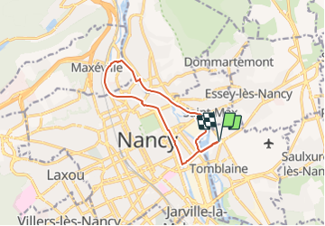
Randonnée Marche de 10,9 km à découvrir à Grand Est, Meurthe-et-Moselle, Tomblaine. Cette randonnée est proposée par DanielROLLET.

Description

2021 07 02 Rando 54 19 participants

Profil altimétrique

Localisation

Pays :
France
Région :
Grand Est
Département/Province :
Meurthe-et-Moselle
Commune :
Tomblaine
Localité :
Unknown
Départ:(UTM)
294755 ; 5397109 (32U) N.

Randonnées à proximité

Randonnée Course à pied Pulnoy - Parcours de santé PULNOY - Photo
Course à pied
DENOMME

Course à pied

Très facile
(1)
Pulnoy, Grand Est, Meurthe-et-Moselle, France
4,8 km | 6 km-effort
58min
Oui
Randonnée A pied Champigneulles - Circuit du Val Saint-Barthélémy - Photo
A pied
GUIDE+

A pied

Facile
Champigneulles, Grand Est, Meurthe-et-Moselle, France
7 km | 8,6 km-effort
1h 57min
Oui
Randonnée A pied Agincourt - Circuit M - Photo
A pied
GUIDE+

A pied

Facile
Agincourt, Grand Est, Meurthe-et-Moselle, France
13,3 km | 17,8 km-effort
4h 3min
Non
Randonnée Marche Nancy - Ma dernière avant opération  - Photo
Marche
Toyot 8

Marche

Très difficile
(1)
Nancy, Grand Est, Meurthe-et-Moselle, France
22 km | 25 km-effort
4h 12min
Oui
Randonnée Marche Vandœuvre-lès-Nancy - Randonnée USEP 2023 - Photo
Marche
nicolas54230

Marche

Difficile
(1)
Vandœuvre-lès-Nancy, Grand Est, Meurthe-et-Moselle, France
11,7 km | 15,2 km-effort
3h 27min
Non
Randonnée Marche Nancy - Ma rando du jour - Photo
Marche
Toyot 8

Marche

Difficile
Nancy, Grand Est, Meurthe-et-Moselle, France
35 km | 41 km-effort
5h 55min
Oui
Randonnée Marche Nancy - Nancy Gondreville Nancy - Photo
Marche
Toyot 8

Marche

Difficile
Nancy, Grand Est, Meurthe-et-Moselle, France
64 km | 74 km-effort
10h 57min
Oui
Randonnée Marche Nancy - Nancy Saizeray Jaillon Pierre la Treiche Marion Nancy  - Photo
Marche
Toyot 8

Marche

Difficile
Nancy, Grand Est, Meurthe-et-Moselle, France
73 km | 85 km-effort
12h 13min
Oui
Randonnée A pied Champigneulles - Circuit du Vallum de la Fourasse - Photo
A pied
GUIDE+

A pied

Facile
Champigneulles, Grand Est, Meurthe-et-Moselle, France
3,3 km | 4,9 km-effort
1h 6min
Oui


Fermer
Mes abonnements