![](/images/other/stat-length.png)
![Randonnée Marche Hotton - Boucle Menil-favay - Rendeux - Werpin - Photo](https://media.geolcdn.com/t/1900/400/ext.pjpeg?maxdim=2&url=https%3A%2F%2Fstatic1.geolcdn.com%2Fsiteimages%2Fupload%2Ffiles%2F1553511878bg_sport_marche.png)
Boucle Menil-favay - Rendeux - Werpin
nico_be
Utilisateur
![Longueur](/images/other/stat-length.png)
Longueur
16 km
![Altitude max](https://static1.geolcdn.com/siteimages/upload/files/1508320355ic_sort_altitude_max_24dp.png)
Altitude max
391 m
![Dénivelé positif](https://static1.geolcdn.com/siteimages/upload/files/1508320355ic_sort_den_pos_24dp.png)
Dénivelé positif
396 m
![Km-Effort](/images/other/stat-length.png)
Km-Effort
21 km
![Altitude min](https://static1.geolcdn.com/siteimages/upload/files/1508320355ic_sort_altitude_min_24dp.png)
Altitude min
177 m
![Dénivelé négatif](https://static1.geolcdn.com/siteimages/upload/files/1508320355ic_sort_den_neg_24dp.png)
Dénivelé négatif
396 m
![Boucle](https://static1.geolcdn.com/siteimages/upload/files/16400158638029165_repeat_loop_refresh_sync_direction_icon.png)
Boucle
Oui
Date de création :
2018-08-06 15:27:03.055
Dernière modification :
2018-08-06 15:27:03.061
![Marche](https://static1.geolcdn.com/sitytour/trail-icons/101.png)
4h34
Difficulté : Moyen
![Scannez ce code QR pour ouvrir la randonnée dans l'application SityTrail](https://capi.geolives.com/qq0zvz2zws4bq2lad0pu/sitytour/trails/272350/qr.png?size=200)
Application GPS de randonnée GRATUITE
À propos
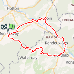
Randonnée Marche de 16 km à découvrir à Wallonie, Luxembourg, Hotton. Cette randonnée est proposée par nico_be.
Description
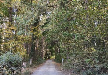
Une magnifique balade entre Menil-Favay et Rendeux passant via bois et prairies dans des endroits calmes et reposants! Quelques côtes entrecoupées de beaux plats ;-)
Localisation
Pays :
Belgique
Région :
Wallonie
Département/Province :
Luxembourg
Commune :
Hotton
Localité :
Hotton
Départ:(Dec)
Départ:(UTM)
673993 ; 5569248 (31U) N.
Commentaires
Randonnées à proximité
![Randonnée Marche Hotton - RB-Lu-04_Marenne - Photo](https://media.geolcdn.com/t/375/260/ext.jpg?maxdim=2&url=https%3A%2F%2Fservices.sitytrail.com%2FGeolivesWS%2FDownloadMedia.ashx%3FTrailID%3D179613%26Media%3Dc1eccb03-838f-4466-b103-ba3011ffaee0.jpg)
![Marche Marche](https://static1.geolcdn.com/sitytour/trail-icons/101.png)
RB-Lu-04_Marenne
Marche
Moyen
(13)
Hotton,
Wallonie,
Luxembourg,
Belgique
![](/images/other/stat-length.png)
18,4 km | 24 km-effort
5h 6min
![](https://static1.geolcdn.com/siteimages/upload/files/16400158638029165_repeat_loop_refresh_sync_direction_icon.png)
Oui
![Randonnée Marche Hotton - RF-Lu-03 Sur la Calestienne, entre Ardenne et Famenne : Hotton - Photo](https://media.geolcdn.com/t/375/260/ext.jpg?maxdim=2&url=https%3A%2F%2Fservices.sitytrail.com%2FGeolivesWS%2FDownloadMedia.ashx%3FTrailID%3D407838%26Media%3D5ce28d25-1425-4e98-96ff-2c6c15aabb08.jpg)
![Marche Marche](https://static1.geolcdn.com/sitytour/trail-icons/101.png)
RF-Lu-03 Sur la Calestienne, entre Ardenne et Famenne : Hotton
Marche
Très facile
(3)
Hotton,
Wallonie,
Luxembourg,
Belgique
![](/images/other/stat-length.png)
11,7 km | 15,3 km-effort
3h 16min
![](https://static1.geolcdn.com/siteimages/upload/files/16400158638029165_repeat_loop_refresh_sync_direction_icon.png)
Oui
![Randonnée Marche Marche-en-Famenne - Champlon - Boucle qui alterne sous-bois et vues dégagées à 360°. Larges sentiers caillouteux et un peu de macadam. - Photo](https://media.geolcdn.com/t/375/260/f9518a34-3708-4717-a5a9-ec6d14ee87bd.jpg&format=jpg&maxdim=2)
![Marche Marche](https://static1.geolcdn.com/sitytour/trail-icons/101.png)
Champlon - Boucle qui alterne sous-bois et vues dégagées à 360°. Larges senti...
Marche
Facile
(1)
Marche-en-Famenne,
Wallonie,
Luxembourg,
Belgique
![](/images/other/stat-length.png)
9,6 km | 12,8 km-effort
2h 23min
![](https://static1.geolcdn.com/siteimages/upload/files/16400158638029165_repeat_loop_refresh_sync_direction_icon.png)
Oui
![Randonnée Marche Hotton - Saint-Pierre - Photo](https://media.geolcdn.com/t/375/260/ext.jpg?maxdim=2&url=https%3A%2F%2Fservices.sitytrail.com%2FGeolivesWS%2FDownloadMedia.ashx%3FTrailID%3D204152%26Media%3D4d13859b-e8ea-464e-b6f5-80f7a1b7659d.jpg)
![Marche Marche](https://static1.geolcdn.com/sitytour/trail-icons/101.png)
Saint-Pierre
Marche
Facile
(3)
Hotton,
Wallonie,
Luxembourg,
Belgique
![](/images/other/stat-length.png)
10,9 km | 12,1 km-effort
2h 43min
![](https://static1.geolcdn.com/siteimages/upload/files/16400158638029165_repeat_loop_refresh_sync_direction_icon.png)
Oui
![Randonnée Marche Hotton - De werpin a werpin via Trinal - Photo](https://media.geolcdn.com/t/375/260/ext.jpg?maxdim=2&url=https%3A%2F%2Fservices.sitytrail.com%2FGeolivesWS%2FDownloadMedia.ashx%3FTrailID%3D225931%26Media%3Dfix__20131007161453.jpg)
![Marche Marche](https://static1.geolcdn.com/sitytour/trail-icons/101.png)
De werpin a werpin via Trinal
Marche
Facile
(1)
Hotton,
Wallonie,
Luxembourg,
Belgique
![](/images/other/stat-length.png)
9,3 km | 12,4 km-effort
2h 38min
![](https://static1.geolcdn.com/siteimages/upload/files/16400158638029165_repeat_loop_refresh_sync_direction_icon.png)
Oui
![Randonnée Marche Hotton - 20241015 - TOTEMUS HOTTON - 5.4 Km - Photo](https://media.geolcdn.com/t/375/260/d43cf3cd-7fde-4960-b7e9-583dcb543dfc.jpeg&format=jpg&maxdim=2)
![Marche Marche](https://static1.geolcdn.com/sitytour/trail-icons/101.png)
20241015 - TOTEMUS HOTTON - 5.4 Km
Marche
Moyen
Hotton,
Wallonie,
Luxembourg,
Belgique
![](/images/other/stat-length.png)
5,4 km | 6,8 km-effort
2h 19min
![](https://static1.geolcdn.com/siteimages/upload/files/16400158638029165_repeat_loop_refresh_sync_direction_icon.png)
Oui
![Randonnée sport Hotton - 2024-07-29_09h57m47_gpxfile - Photo](https://media.geolcdn.com/t/375/260/ext.jpg?maxdim=2&url=https%3A%2F%2Fsecurestorage.geolives.com%2Fsitytour%2Ftrail-bg%2Fdefault.jpg)
2024-07-29_09h57m47_gpxfile
sport
Très facile
(1)
Hotton,
Wallonie,
Luxembourg,
Belgique
![](/images/other/stat-length.png)
9,3 km | 13 km-effort
Inconnu
![](https://static1.geolcdn.com/siteimages/upload/files/16400158638029165_repeat_loop_refresh_sync_direction_icon.png)
Oui
![Randonnée Marche Hotton - Balade à Hotton - Photo](https://media.geolcdn.com/t/375/260/768efbbe-c567-45b1-bd57-69176b5f50b6.jpeg&format=jpg&maxdim=2)
![Marche Marche](https://static1.geolcdn.com/sitytour/trail-icons/101.png)
Balade à Hotton
Marche
Moyen
Hotton,
Wallonie,
Luxembourg,
Belgique
![](/images/other/stat-length.png)
7,1 km | 8,9 km-effort
2h 0min
![](https://static1.geolcdn.com/siteimages/upload/files/16400158638029165_repeat_loop_refresh_sync_direction_icon.png)
Non
Très joli et varié