![](/images/other/stat-length.png)
![Randonnée Marche nordique Hoéville - Hoëville 10 360m +177m - Photo](https://media.geolcdn.com/t/1900/400/ext.pjpeg?maxdim=2&url=https%3A%2F%2Fstatic1.geolcdn.com%2Fsiteimages%2Fupload%2Ffiles%2F1545311037marcheuse_200dpi.jpg)
Hoëville 10 360m +177m
DanielROLLET
Utilisateur
![Longueur](/images/other/stat-length.png)
Longueur
10,4 km
![Altitude max](https://static1.geolcdn.com/siteimages/upload/files/1508320355ic_sort_altitude_max_24dp.png)
Altitude max
320 m
![Dénivelé positif](https://static1.geolcdn.com/siteimages/upload/files/1508320355ic_sort_den_pos_24dp.png)
Dénivelé positif
177 m
![Km-Effort](/images/other/stat-length.png)
Km-Effort
12,7 km
![Altitude min](https://static1.geolcdn.com/siteimages/upload/files/1508320355ic_sort_altitude_min_24dp.png)
Altitude min
244 m
![Dénivelé négatif](https://static1.geolcdn.com/siteimages/upload/files/1508320355ic_sort_den_neg_24dp.png)
Dénivelé négatif
178 m
![Boucle](https://static1.geolcdn.com/siteimages/upload/files/16400158638029165_repeat_loop_refresh_sync_direction_icon.png)
Boucle
Oui
Date de création :
2021-03-25 07:56:14.437
Dernière modification :
2021-03-25 18:45:11.045
![Marche nordique](https://static1.geolcdn.com/sitytour/trail-icons/102.png)
2h25
Difficulté : Facile
![Scannez ce code QR pour ouvrir la randonnée dans l'application SityTrail](https://capi.geolives.com/qq0zvz2zws4bq2lad0pu/sitytour/trails/2720725/qr.png?size=200)
Application GPS de randonnée GRATUITE
À propos
Randonnée Marche nordique de 10,4 km à découvrir à Grand Est, Meurthe-et-Moselle, Hoéville. Cette randonnée est proposée par DanielROLLET.
Description
2021 03 25 marche nordique - 10 personnes - 8h55 à 11h20
Beaucoup d'arrêts sur circuit avec vestiges militaires et panneaux pédo floristiques. beaucoup de pertes de temps
Localisation
Pays :
France
Région :
Grand Est
Département/Province :
Meurthe-et-Moselle
Commune :
Hoéville
Localité :
Unknown
Départ:(Dec)
Départ:(UTM)
311563 ; 5398280 (32U) N.
Commentaires
Randonnées à proximité
![Randonnée Marche Athienville - Athienville - Photo](https://media.geolcdn.com/t/375/260/3f59f207-c753-4711-9150-12a09b3369cc.jpg&format=jpg&maxdim=2)
![Marche Marche](https://static1.geolcdn.com/sitytour/trail-icons/101.png)
Athienville
Marche
Moyen
Athienville,
Grand Est,
Meurthe-et-Moselle,
France
![](/images/other/stat-length.png)
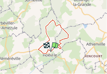
13,9 km | 17 km-effort
3h 34min
![](https://static1.geolcdn.com/siteimages/upload/files/16400158638029165_repeat_loop_refresh_sync_direction_icon.png)
Oui
![Randonnée Marche Hoéville - Bezange la grande - Photo](https://media.geolcdn.com/t/375/260/9b5cd856-989e-4277-b7db-cbc4b835c071.jpg&format=jpg&maxdim=2)
![Marche Marche](https://static1.geolcdn.com/sitytour/trail-icons/101.png)
Bezange la grande
Marche
Moyen
Hoéville,
Grand Est,
Meurthe-et-Moselle,
France
![](/images/other/stat-length.png)
8,9 km | 11,2 km-effort
3h 1min
![](https://static1.geolcdn.com/siteimages/upload/files/16400158638029165_repeat_loop_refresh_sync_direction_icon.png)
Oui
![Randonnée sport Réméréville - LM remereville - Photo](https://media.geolcdn.com/t/375/260/ext.jpg?maxdim=2&url=https%3A%2F%2Fsecurestorage.geolives.com%2Fsitytour%2Ftrail-bg%2Fdefault.jpg)
LM remereville
sport
Très facile
Réméréville,
Grand Est,
Meurthe-et-Moselle,
France
![](/images/other/stat-length.png)
11,1 km | 12,8 km-effort
Inconnu
![](https://static1.geolcdn.com/siteimages/upload/files/16400158638029165_repeat_loop_refresh_sync_direction_icon.png)
Oui
![Randonnée Marche nordique Hoéville - Hoeville 9 110m +161m - Photo](https://media.geolcdn.com/t/375/260/ext.jpg?maxdim=2&url=https%3A%2F%2Fstatic1.geolcdn.com%2Fsiteimages%2Fupload%2Ffiles%2F1545311037marcheuse_200dpi.jpg)
![Marche nordique Marche nordique](https://static1.geolcdn.com/sitytour/trail-icons/102.png)
Hoeville 9 110m +161m
Marche nordique
Facile
Hoéville,
Grand Est,
Meurthe-et-Moselle,
France
![](/images/other/stat-length.png)
9,1 km | 11,3 km-effort
2h 15min
![](https://static1.geolcdn.com/siteimages/upload/files/16400158638029165_repeat_loop_refresh_sync_direction_icon.png)
Oui
![Randonnée Marche Valhey - Audax Valhey - Photo](https://media.geolcdn.com/t/375/260/7387f96a-9ac6-4142-b662-59fbde883b80.jpg&format=jpg&maxdim=2)
![Marche Marche](https://static1.geolcdn.com/sitytour/trail-icons/101.png)
Audax Valhey
Marche
Moyen
Valhey,
Grand Est,
Meurthe-et-Moselle,
France
![](/images/other/stat-length.png)
49 km | 57 km-effort
8h 6min
![](https://static1.geolcdn.com/siteimages/upload/files/16400158638029165_repeat_loop_refresh_sync_direction_icon.png)
Oui
![Randonnée Marche Sornéville - Sornéville_10km - Photo](https://media.geolcdn.com/t/375/260/ext.jpg?maxdim=2&url=https%3A%2F%2Fstatic1.geolcdn.com%2Fsiteimages%2Fupload%2Ffiles%2F1553511878bg_sport_marche.png)
![Marche Marche](https://static1.geolcdn.com/sitytour/trail-icons/101.png)
Sornéville_10km
Marche
Moyen
Sornéville,
Grand Est,
Meurthe-et-Moselle,
France
![](/images/other/stat-length.png)
9,7 km | 11,5 km-effort
2h 37min
![](https://static1.geolcdn.com/siteimages/upload/files/16400158638029165_repeat_loop_refresh_sync_direction_icon.png)
Oui
![Randonnée Marche nordique Bezange-la-Grande - Bezange-la-Grande 9 170m +151m - Photo](https://media.geolcdn.com/t/375/260/ext.jpg?maxdim=2&url=https%3A%2F%2Fstatic1.geolcdn.com%2Fsiteimages%2Fupload%2Ffiles%2F1545311037marcheuse_200dpi.jpg)
![Marche nordique Marche nordique](https://static1.geolcdn.com/sitytour/trail-icons/102.png)
Bezange-la-Grande 9 170m +151m
Marche nordique
Facile
Bezange-la-Grande,
Grand Est,
Meurthe-et-Moselle,
France
![](/images/other/stat-length.png)
9,2 km | 11,2 km-effort
2h 0min
![](https://static1.geolcdn.com/siteimages/upload/files/16400158638029165_repeat_loop_refresh_sync_direction_icon.png)
Oui
![Randonnée Marche Réméréville - Remereville_11km - Photo](https://media.geolcdn.com/t/375/260/ext.jpg?maxdim=2&url=https%3A%2F%2Fstatic1.geolcdn.com%2Fsiteimages%2Fupload%2Ffiles%2F1553511878bg_sport_marche.png)
![Marche Marche](https://static1.geolcdn.com/sitytour/trail-icons/101.png)
Remereville_11km
Marche
Très facile
(1)
Réméréville,
Grand Est,
Meurthe-et-Moselle,
France
![](/images/other/stat-length.png)
10,9 km | 12,7 km-effort
2h 50min
![](https://static1.geolcdn.com/siteimages/upload/files/16400158638029165_repeat_loop_refresh_sync_direction_icon.png)
Oui
![Randonnée Marche Erbéviller-sur-Amezule - Erbeviller sur Amezule_8,5km - Photo](https://media.geolcdn.com/t/375/260/ext.jpg?maxdim=2&url=https%3A%2F%2Fstatic1.geolcdn.com%2Fsiteimages%2Fupload%2Ffiles%2F1553511878bg_sport_marche.png)
![Marche Marche](https://static1.geolcdn.com/sitytour/trail-icons/101.png)
Erbeviller sur Amezule_8,5km
Marche
Moyen
(1)
Erbéviller-sur-Amezule,
Grand Est,
Meurthe-et-Moselle,
France
![](/images/other/stat-length.png)
8,5 km | 10,3 km-effort
2h 14min
![](https://static1.geolcdn.com/siteimages/upload/files/16400158638029165_repeat_loop_refresh_sync_direction_icon.png)
Oui