![](/images/other/stat-length.png)
![Randonnée Marche Irouléguy - Boucle Irouléguy Jara - Photo](https://media.geolcdn.com/t/1900/400/ext.pjpeg?maxdim=2&url=https%3A%2F%2Fstatic1.geolcdn.com%2Fsiteimages%2Fupload%2Ffiles%2F1553511878bg_sport_marche.png)
Boucle Irouléguy Jara
pacha56
Utilisateur
![Longueur](/images/other/stat-length.png)
Longueur
13,2 km
![Altitude max](https://static1.geolcdn.com/siteimages/upload/files/1508320355ic_sort_altitude_max_24dp.png)
Altitude max
805 m
![Dénivelé positif](https://static1.geolcdn.com/siteimages/upload/files/1508320355ic_sort_den_pos_24dp.png)
Dénivelé positif
633 m
![Km-Effort](/images/other/stat-length.png)
Km-Effort
22 km
![Altitude min](https://static1.geolcdn.com/siteimages/upload/files/1508320355ic_sort_altitude_min_24dp.png)
Altitude min
212 m
![Dénivelé négatif](https://static1.geolcdn.com/siteimages/upload/files/1508320355ic_sort_den_neg_24dp.png)
Dénivelé négatif
632 m
![Boucle](https://static1.geolcdn.com/siteimages/upload/files/16400158638029165_repeat_loop_refresh_sync_direction_icon.png)
Boucle
Oui
Date de création :
2021-03-23 09:11:52.708
Dernière modification :
2021-03-23 18:18:59.355
![Marche](https://static1.geolcdn.com/sitytour/trail-icons/101.png)
5h21
Difficulté : Facile
![Scannez ce code QR pour ouvrir la randonnée dans l'application SityTrail](https://capi.geolives.com/qq0zvz2zws4bq2lad0pu/sitytour/trails/2718689/qr.png?size=200)
Application GPS de randonnée GRATUITE
À propos
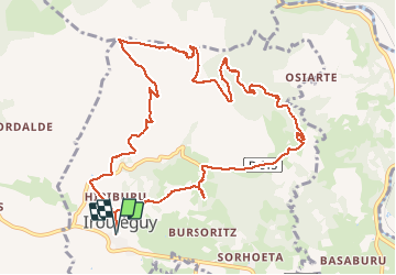
Randonnée Marche de 13,2 km à découvrir à Nouvelle-Aquitaine, Pyrénées-Atlantiques, Irouléguy. Cette randonnée est proposée par pacha56.
Description
Belle balade, avec vue sur les Pyrénées enneigées et retour en passant par les dolmens d' Arrodondo et Artxvita
Localisation
Pays :
France
Région :
Nouvelle-Aquitaine
Département/Province :
Pyrénées-Atlantiques
Commune :
Irouléguy
Localité :
Unknown
Départ:(Dec)
Départ:(UTM)
638158 ; 4782024 (30T) N.
Commentaires
Randonnées à proximité
![Randonnée Marche Ispoure - arradoy G4Fait - Photo](https://media.geolcdn.com/t/375/260/b1d4f481-6895-478c-81f3-6ef884c4075d.jpg&format=jpg&maxdim=2)
![Marche Marche](https://static1.geolcdn.com/sitytour/trail-icons/101.png)
arradoy G4Fait
Marche
Très facile
Ispoure,
Nouvelle-Aquitaine,
Pyrénées-Atlantiques,
France
![](/images/other/stat-length.png)
6 km | 9,7 km-effort
4h 14min
![](https://static1.geolcdn.com/siteimages/upload/files/16400158638029165_repeat_loop_refresh_sync_direction_icon.png)
Oui
![Randonnée Marche Ispoure - Arradoy - Photo](https://media.geolcdn.com/t/375/260/ext.jpg?maxdim=2&url=https%3A%2F%2Fstatic1.geolcdn.com%2Fsiteimages%2Fupload%2Ffiles%2F1553511878bg_sport_marche.png)
![Marche Marche](https://static1.geolcdn.com/sitytour/trail-icons/101.png)
Arradoy
Marche
Facile
(2)
Ispoure,
Nouvelle-Aquitaine,
Pyrénées-Atlantiques,
France
![](/images/other/stat-length.png)
6 km | 9,6 km-effort
2h 2min
![](https://static1.geolcdn.com/siteimages/upload/files/16400158638029165_repeat_loop_refresh_sync_direction_icon.png)
Oui
![Randonnée Marche Saint-Étienne-de-Baïgorry - iparla - Photo](https://media.geolcdn.com/t/375/260/ext.jpg?maxdim=2&url=https%3A%2F%2Fstatic1.geolcdn.com%2Fsiteimages%2Fupload%2Ffiles%2F1553511878bg_sport_marche.png)
![Marche Marche](https://static1.geolcdn.com/sitytour/trail-icons/101.png)
iparla
Marche
Très facile
(1)
Saint-Étienne-de-Baïgorry,
Nouvelle-Aquitaine,
Pyrénées-Atlantiques,
France
![](/images/other/stat-length.png)
13,5 km | 25 km-effort
4h 45min
![](https://static1.geolcdn.com/siteimages/upload/files/16400158638029165_repeat_loop_refresh_sync_direction_icon.png)
Oui
![Randonnée Marche Ispoure - Arradoy - Photo](https://media.geolcdn.com/t/375/260/dad09f6b-17f2-454c-80e0-b56c173ff2a7.jpg&format=jpg&maxdim=2)
![Marche Marche](https://static1.geolcdn.com/sitytour/trail-icons/101.png)
Arradoy
Marche
Facile
Ispoure,
Nouvelle-Aquitaine,
Pyrénées-Atlantiques,
France
![](/images/other/stat-length.png)
6,1 km | 9,7 km-effort
1h 35min
![](https://static1.geolcdn.com/siteimages/upload/files/16400158638029165_repeat_loop_refresh_sync_direction_icon.png)
Oui
![Randonnée Marche Saint-Jean-Pied-de-Port - Saint-Jean-Pied-de-Port Gr 65 - Photo](https://media.geolcdn.com/t/375/260/be1151ba-0eae-47f2-a1b3-ca8e7b17585f.jpg&format=jpg&maxdim=2)
![Marche Marche](https://static1.geolcdn.com/sitytour/trail-icons/101.png)
Saint-Jean-Pied-de-Port Gr 65
Marche
Facile
Saint-Jean-Pied-de-Port,
Nouvelle-Aquitaine,
Pyrénées-Atlantiques,
France
![](/images/other/stat-length.png)
4,5 km | 5,8 km-effort
1h 12min
![](https://static1.geolcdn.com/siteimages/upload/files/16400158638029165_repeat_loop_refresh_sync_direction_icon.png)
Oui
![Randonnée Marche Saint-Jean-Pied-de-Port - Saint-Jean-Pied-de-Port, la citadelle - Photo](https://media.geolcdn.com/t/375/260/713cbf20-81b6-4133-bdc9-cae24b6f18c3.jpg&format=jpg&maxdim=2)
![Marche Marche](https://static1.geolcdn.com/sitytour/trail-icons/101.png)
Saint-Jean-Pied-de-Port, la citadelle
Marche
Moyen
Saint-Jean-Pied-de-Port,
Nouvelle-Aquitaine,
Pyrénées-Atlantiques,
France
![](/images/other/stat-length.png)
7,5 km | 9,6 km-effort
2h 58min
![](https://static1.geolcdn.com/siteimages/upload/files/16400158638029165_repeat_loop_refresh_sync_direction_icon.png)
Oui
![Randonnée Marche Saint-Étienne-de-Baïgorry - GR 10 5ème étape : St Étienne de Baïgorry - St Jean Pied De Port - Photo](https://media.geolcdn.com/t/375/260/f423bfc4-7ba2-4899-9de2-d0d00676b5d2.jpg&format=jpg&maxdim=2)
![Marche Marche](https://static1.geolcdn.com/sitytour/trail-icons/101.png)
GR 10 5ème étape : St Étienne de Baïgorry - St Jean Pied De Port
Marche
Moyen
Saint-Étienne-de-Baïgorry,
Nouvelle-Aquitaine,
Pyrénées-Atlantiques,
France
![](/images/other/stat-length.png)
22 km | 36 km-effort
4h 31min
![](https://static1.geolcdn.com/siteimages/upload/files/16400158638029165_repeat_loop_refresh_sync_direction_icon.png)
Non
![Randonnée Marche Saint-Étienne-de-Baïgorry - Chapelle ailandoi depuis st Etienne Baïgorry - Photo](https://media.geolcdn.com/t/375/260/bb12cce8-d7ba-4ea6-9157-caee9a53015d.jpg&format=jpg&maxdim=2)
![Marche Marche](https://static1.geolcdn.com/sitytour/trail-icons/101.png)
Chapelle ailandoi depuis st Etienne Baïgorry
Marche
(2)
Saint-Étienne-de-Baïgorry,
Nouvelle-Aquitaine,
Pyrénées-Atlantiques,
France
![](/images/other/stat-length.png)
13,2 km | 24 km-effort
3h 53min
![](https://static1.geolcdn.com/siteimages/upload/files/16400158638029165_repeat_loop_refresh_sync_direction_icon.png)
Oui
![Randonnée Marche Saint-Étienne-de-Baïgorry - Boucle oylarandoy - Photo](https://media.geolcdn.com/t/375/260/1ab54b66-7f67-4257-86b8-a3289cdc40c1.jpg&format=jpg&maxdim=2)
![Marche Marche](https://static1.geolcdn.com/sitytour/trail-icons/101.png)
Boucle oylarandoy
Marche
Moyen
Saint-Étienne-de-Baïgorry,
Nouvelle-Aquitaine,
Pyrénées-Atlantiques,
France
![](/images/other/stat-length.png)
14,3 km | 25 km-effort
4h 55min
![](https://static1.geolcdn.com/siteimages/upload/files/16400158638029165_repeat_loop_refresh_sync_direction_icon.png)
Oui