![](/images/other/stat-length.png)
![Randonnée V.T.T. Vaux-le-Pénil - Vaux le P Chateletautre - Photo](https://media.geolcdn.com/t/1900/400/ext.pjpeg?maxdim=2&url=https%3A%2F%2Fstatic1.geolcdn.com%2Fsiteimages%2Fupload%2Ffiles%2F1524743154velo.jpg)
Vaux le P Chateletautre
Emile52
Utilisateur
![Longueur](/images/other/stat-length.png)
Longueur
10,7 km
![Altitude max](https://static1.geolcdn.com/siteimages/upload/files/1508320355ic_sort_altitude_max_24dp.png)
Altitude max
105 m
![Dénivelé positif](https://static1.geolcdn.com/siteimages/upload/files/1508320355ic_sort_den_pos_24dp.png)
Dénivelé positif
92 m
![Km-Effort](/images/other/stat-length.png)
Km-Effort
11,9 km
![Altitude min](https://static1.geolcdn.com/siteimages/upload/files/1508320355ic_sort_altitude_min_24dp.png)
Altitude min
68 m
![Dénivelé négatif](https://static1.geolcdn.com/siteimages/upload/files/1508320355ic_sort_den_neg_24dp.png)
Dénivelé négatif
75 m
![Boucle](https://static1.geolcdn.com/siteimages/upload/files/16400158638029165_repeat_loop_refresh_sync_direction_icon.png)
Boucle
Non
Date de création :
2020-05-14 09:32:14.04
Dernière modification :
2021-08-22 15:45:13.634
![V.T.T.](https://static1.geolcdn.com/sitytour/trail-icons/202.png)
52m
Difficulté : Facile
![Scannez ce code QR pour ouvrir la randonnée dans l'application SityTrail](https://capi.geolives.com/qq0zvz2zws4bq2lad0pu/sitytour/trails/2716485/qr.png?size=200)
Application GPS de randonnée GRATUITE
À propos
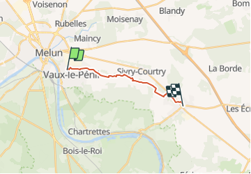
Randonnée V.T.T. de 10,7 km à découvrir à Île-de-France, Seine-et-Marne, Vaux-le-Pénil. Cette randonnée est proposée par Emile52.
Description
Chemin de Vaux le pénil à Le Chatelet évitant par le nord la partie défoncée par l'exploitation de la carrière du tertre de Berceau.
Localisation
Pays :
France
Région :
Île-de-France
Département/Province :
Seine-et-Marne
Commune :
Vaux-le-Pénil
Localité :
Unknown
Départ:(Dec)
Départ:(UTM)
476300 ; 5375094 (31U) N.
Commentaires
Randonnées à proximité
![Randonnée V.T.T. Melun - melun-bas.samois - Photo](https://media.geolcdn.com/t/375/260/ext.jpg?maxdim=2&url=https%3A%2F%2Fservices.sitytrail.com%2FGeolivesWS%2FDownloadMedia.ashx%3FTrailID%3D201635%26Media%3D20130630104925.jpeg)
![V.T.T. V.T.T.](https://static1.geolcdn.com/sitytour/trail-icons/202.png)
melun-bas.samois
V.T.T.
Moyen
(1)
Melun,
Île-de-France,
Seine-et-Marne,
France
![](/images/other/stat-length.png)
38 km | 43 km-effort
2h 45min
![](https://static1.geolcdn.com/siteimages/upload/files/16400158638029165_repeat_loop_refresh_sync_direction_icon.png)
Oui
![Randonnée Marche Melun - Le tour du Grand Paris via le gr1 : Etape 13 Melun Barbizon - Photo](https://media.geolcdn.com/t/375/260/43fa91c6-5130-4300-b61c-33f1d532d9df.jpg&format=jpg&maxdim=2)
![Marche Marche](https://static1.geolcdn.com/sitytour/trail-icons/101.png)
Le tour du Grand Paris via le gr1 : Etape 13 Melun Barbizon
Marche
Facile
Melun,
Île-de-France,
Seine-et-Marne,
France
![](/images/other/stat-length.png)
27 km | 33 km-effort
5h 55min
![](https://static1.geolcdn.com/siteimages/upload/files/16400158638029165_repeat_loop_refresh_sync_direction_icon.png)
Non
![Randonnée Marche Vert-Saint-Denis - 20220330 - Forêt de Bréviande 15km - Photo](https://media.geolcdn.com/t/375/260/ext.jpg?maxdim=2&url=https%3A%2F%2Fstatic1.geolcdn.com%2Fsiteimages%2Fupload%2Ffiles%2F1553511878bg_sport_marche.png)
![Marche Marche](https://static1.geolcdn.com/sitytour/trail-icons/101.png)
20220330 - Forêt de Bréviande 15km
Marche
Difficile
(1)
Vert-Saint-Denis,
Île-de-France,
Seine-et-Marne,
France
![](/images/other/stat-length.png)
14,6 km | 16,3 km-effort
3h 42min
![](https://static1.geolcdn.com/siteimages/upload/files/16400158638029165_repeat_loop_refresh_sync_direction_icon.png)
Oui
![Randonnée A pied Maincy - L 40 Sur les pas de Paul Cézanne à Maincy - Photo](https://media.geolcdn.com/t/375/260/ext.jpg?maxdim=2&url=https%3A%2F%2Fstatic1.geolcdn.com%2Fsiteimages%2Fupload%2Ffiles%2F1545311037marcheuse_200dpi.jpg)
![A pied A pied](https://static1.geolcdn.com/sitytour/trail-icons/100.png)
L 40 Sur les pas de Paul Cézanne à Maincy
A pied
Très facile
(3)
Maincy,
Île-de-France,
Seine-et-Marne,
France
![](/images/other/stat-length.png)
6 km | 7,2 km-effort
1h 38min
![](https://static1.geolcdn.com/siteimages/upload/files/16400158638029165_repeat_loop_refresh_sync_direction_icon.png)
Oui
![Randonnée Marche Chartrettes - Boucle 20 km autour de Chartrettes - Photo](https://media.geolcdn.com/t/375/260/b04db295-04e4-48e9-8daa-b62583fbe9b3.jpg&format=jpg&maxdim=2)
![Marche Marche](https://static1.geolcdn.com/sitytour/trail-icons/101.png)
Boucle 20 km autour de Chartrettes
Marche
Très facile
Chartrettes,
Île-de-France,
Seine-et-Marne,
France
![](/images/other/stat-length.png)
19,9 km | 23 km-effort
4h 32min
![](https://static1.geolcdn.com/siteimages/upload/files/16400158638029165_repeat_loop_refresh_sync_direction_icon.png)
Oui
![Randonnée Marche Maincy - vaux le pénil - blandy les tours - Photo](https://media.geolcdn.com/t/375/260/5344f78f-37de-4136-b4f8-4ce06f4e96e0.jpg&format=jpg&maxdim=2)
![Marche Marche](https://static1.geolcdn.com/sitytour/trail-icons/101.png)
vaux le pénil - blandy les tours
Marche
Très facile
Maincy,
Île-de-France,
Seine-et-Marne,
France
![](/images/other/stat-length.png)
21 km | 24 km-effort
5h 44min
![](https://static1.geolcdn.com/siteimages/upload/files/16400158638029165_repeat_loop_refresh_sync_direction_icon.png)
Oui
![Randonnée Marche Melun - Melun -- charrettes - Photo](https://media.geolcdn.com/t/375/260/ext.jpg?maxdim=2&url=https%3A%2F%2Fservices.sitytrail.com%2FGeolivesWS%2FDownloadMedia.ashx%3FTrailID%3D201785%26Media%3D20130630163457.jpg)
![Marche Marche](https://static1.geolcdn.com/sitytour/trail-icons/101.png)
Melun -- charrettes
Marche
Très facile
Melun,
Île-de-France,
Seine-et-Marne,
France
![](/images/other/stat-length.png)
14,7 km | 16,5 km-effort
3h 48min
![](https://static1.geolcdn.com/siteimages/upload/files/16400158638029165_repeat_loop_refresh_sync_direction_icon.png)
Non
![Randonnée Marche La Rochette - de Bois le Roy à Melun - Photo](https://media.geolcdn.com/t/375/260/ext.jpg?maxdim=2&url=https%3A%2F%2Fservices.sitytrail.com%2FGeolivesWS%2FDownloadMedia.ashx%3FTrailID%3D191678%26Media%3D20130512194836.jpg)
![Marche Marche](https://static1.geolcdn.com/sitytour/trail-icons/101.png)
de Bois le Roy à Melun
Marche
Très facile
La Rochette,
Île-de-France,
Seine-et-Marne,
France
![](/images/other/stat-length.png)
15,7 km | 17,5 km-effort
4h 20min
![](https://static1.geolcdn.com/siteimages/upload/files/16400158638029165_repeat_loop_refresh_sync_direction_icon.png)
Non
![Randonnée Marche Le Mée-sur-Seine - Melun 01 - Photo](https://media.geolcdn.com/t/375/260/ext.jpg?maxdim=2&url=https%3A%2F%2Fservices.sitytrail.com%2FGeolivesWS%2FDownloadMedia.ashx%3FTrailID%3D183579%26Media%3D20130407182853.jpg)
![Marche Marche](https://static1.geolcdn.com/sitytour/trail-icons/101.png)
Melun 01
Marche
Très facile
Le Mée-sur-Seine,
Île-de-France,
Seine-et-Marne,
France
![](/images/other/stat-length.png)
8 km | 9,1 km-effort
4h 26min
![](https://static1.geolcdn.com/siteimages/upload/files/16400158638029165_repeat_loop_refresh_sync_direction_icon.png)
Non