![](/images/other/stat-length.png)
![Randonnée Marche Vif - Circuit entre Vif et les sources de l'Echaillon par la cabane d'Uriol avec retour par Champrond - Photo](https://media.geolcdn.com/t/1900/400/064ad078-4d4b-4439-8dbb-d18d7e525498.jpg&format=pjpeg&maxdim=2)
Circuit entre Vif et les sources de l'Echaillon par la cabane d'Uriol avec retour par Champrond
Emelle
Utilisateur
![Longueur](/images/other/stat-length.png)
![Altitude max](https://static1.geolcdn.com/siteimages/upload/files/1508320355ic_sort_altitude_max_24dp.png)
![Dénivelé positif](https://static1.geolcdn.com/siteimages/upload/files/1508320355ic_sort_den_pos_24dp.png)
![Km-Effort](/images/other/stat-length.png)
![Altitude min](https://static1.geolcdn.com/siteimages/upload/files/1508320355ic_sort_altitude_min_24dp.png)
![Dénivelé négatif](https://static1.geolcdn.com/siteimages/upload/files/1508320355ic_sort_den_neg_24dp.png)
![Boucle](https://static1.geolcdn.com/siteimages/upload/files/16400158638029165_repeat_loop_refresh_sync_direction_icon.png)
![Marche](https://static1.geolcdn.com/sitytour/trail-icons/101.png)
6h03
Difficulté : Moyen
![Scannez ce code QR pour ouvrir la randonnée dans l'application SityTrail](https://capi.geolives.com/qq0zvz2zws4bq2lad0pu/sitytour/trails/2716213/qr.png?size=200)
Application GPS de randonnée GRATUITE
À propos
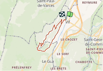
Randonnée Marche de 12,5 km à découvrir à Auvergne-Rhône-Alpes, Isère, Vif. Cette randonnée est proposée par Emelle.
Description
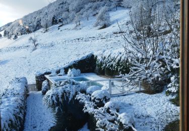
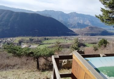
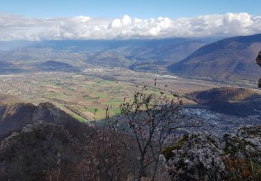
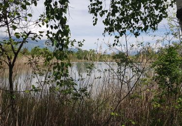
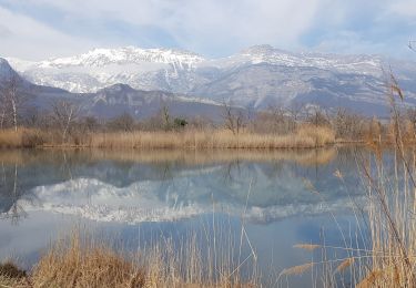
Très beau circuit sans difficulté par une belle journée printanière avec de beaux points de vue sur les massifs environnants.
Découverte d'un petit diverticule hors sentier balisé qui arrive un peu avant la cabane d'Uriol.
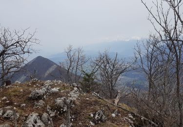
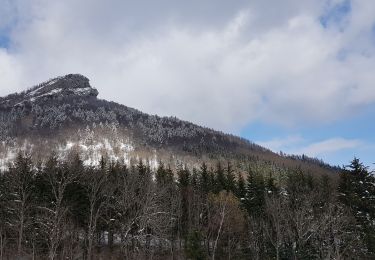
Pique-nique au soleil sous l'arête sud qui mène au sommet du Pieu.
Retour par Champrond par un sentier non balisé mais bien sur la carte.
Les 2 derniers dos d'âne à la fin peuvent impressionner mais finalement se passent sans difficultés.
Localisation
Commentaires
Randonnées à proximité
![Randonnée Marche Claix - Le balcon du pic Saint Michel Par la grotte des pouliches - Photo](https://media.geolcdn.com/t/375/260/26eba98c-7ea6-42d6-9ec9-9d07c3062889.jpg&format=jpg&maxdim=2)
![Marche Marche](https://static1.geolcdn.com/sitytour/trail-icons/101.png)
Marche
![](/images/other/stat-length.png)
![](https://static1.geolcdn.com/siteimages/upload/files/16400158638029165_repeat_loop_refresh_sync_direction_icon.png)
![Randonnée Marche Varces-Allières-et-Risset - Les Etangs de Reymure réaménagés en 2023. - Photo](https://media.geolcdn.com/t/375/260/a9036917-cc32-4324-8d0a-4d872f501612.jpg&format=jpg&maxdim=2)
![Marche Marche](https://static1.geolcdn.com/sitytour/trail-icons/101.png)
Marche
![](/images/other/stat-length.png)
![](https://static1.geolcdn.com/siteimages/upload/files/16400158638029165_repeat_loop_refresh_sync_direction_icon.png)
![Randonnée Marche Vif - la ferme oriol en circuit - Photo](https://media.geolcdn.com/t/375/260/40456475-f1df-45a6-819a-93e9ddb16412.jpg&format=jpg&maxdim=2)
![Marche Marche](https://static1.geolcdn.com/sitytour/trail-icons/101.png)
Marche
![](/images/other/stat-length.png)
![](https://static1.geolcdn.com/siteimages/upload/files/16400158638029165_repeat_loop_refresh_sync_direction_icon.png)
![Randonnée Marche Saint-Georges-de-Commiers - Boucle autour de Saint Georges de Commiers - Photo](https://media.geolcdn.com/t/375/260/0bfddc52-e2d2-4332-a925-7e71f6c56a54.jpg&format=jpg&maxdim=2)
![Marche Marche](https://static1.geolcdn.com/sitytour/trail-icons/101.png)
Marche
![](/images/other/stat-length.png)
![](https://static1.geolcdn.com/siteimages/upload/files/16400158638029165_repeat_loop_refresh_sync_direction_icon.png)
![Randonnée Marche Le Gua - Un tour de L'Eperrimont par le sommet ! - Photo](https://media.geolcdn.com/t/375/260/86c123e6-6997-4f93-970a-703604abf85f.jpg&format=jpg&maxdim=2)
![Marche Marche](https://static1.geolcdn.com/sitytour/trail-icons/101.png)
Marche
![](/images/other/stat-length.png)
![](https://static1.geolcdn.com/siteimages/upload/files/16400158638029165_repeat_loop_refresh_sync_direction_icon.png)
![Randonnée Marche Le Gua - Le Pieu depuis Les Petits Amieux - Photo](https://media.geolcdn.com/t/375/260/bc0f1a32-2a26-4597-a0e3-8997a2b8a6b8.jpg&format=jpg&maxdim=2)
![Marche Marche](https://static1.geolcdn.com/sitytour/trail-icons/101.png)
Marche
![](/images/other/stat-length.png)
![](https://static1.geolcdn.com/siteimages/upload/files/16400158638029165_repeat_loop_refresh_sync_direction_icon.png)
![Randonnée Marche nordique Vif - Les Etangs de la Plaine de Reymure - Photo](https://media.geolcdn.com/t/375/260/1d6be850-f5d4-4e8e-a42b-a881c0492ad2.jpg&format=jpg&maxdim=2)
![Marche nordique Marche nordique](https://static1.geolcdn.com/sitytour/trail-icons/102.png)
Marche nordique
![](/images/other/stat-length.png)
![](https://static1.geolcdn.com/siteimages/upload/files/16400158638029165_repeat_loop_refresh_sync_direction_icon.png)
![Randonnée Marche nordique Varces-Allières-et-Risset - De la plaine de Reymure au canal de Malissolles - Photo](https://media.geolcdn.com/t/375/260/3d91b17d-7f71-4e45-96ae-37747dd4929a.jpg&format=jpg&maxdim=2)
![Marche nordique Marche nordique](https://static1.geolcdn.com/sitytour/trail-icons/102.png)
Marche nordique
![](/images/other/stat-length.png)
![](https://static1.geolcdn.com/siteimages/upload/files/16400158638029165_repeat_loop_refresh_sync_direction_icon.png)
![Randonnée Marche Le Gua - L'Eperrimont ou l'Indien en mode hivernal - Photo](https://media.geolcdn.com/t/375/260/14d17471-c49b-4ce8-9fe1-a90ccbaf7a8b.jpg&format=jpg&maxdim=2)
![Marche Marche](https://static1.geolcdn.com/sitytour/trail-icons/101.png)
Marche
![](/images/other/stat-length.png)
![](https://static1.geolcdn.com/siteimages/upload/files/16400158638029165_repeat_loop_refresh_sync_direction_icon.png)