![](/images/other/stat-length.png)
![Randonnée Marche Cancale - Cancale - Pointe du Grouin - Photo](https://media.geolcdn.com/t/1900/400/cdfca10d-fb48-45f4-8bf8-c284ecabd948.jpg&format=pjpeg&maxdim=2)
Cancale - Pointe du Grouin
meunier.ph.
Utilisateur
![Longueur](/images/other/stat-length.png)
Longueur
14,7 km
![Altitude max](https://static1.geolcdn.com/siteimages/upload/files/1508320355ic_sort_altitude_max_24dp.png)
Altitude max
51 m
![Dénivelé positif](https://static1.geolcdn.com/siteimages/upload/files/1508320355ic_sort_den_pos_24dp.png)
Dénivelé positif
228 m
![Km-Effort](/images/other/stat-length.png)
Km-Effort
17,7 km
![Altitude min](https://static1.geolcdn.com/siteimages/upload/files/1508320355ic_sort_altitude_min_24dp.png)
Altitude min
3 m
![Dénivelé négatif](https://static1.geolcdn.com/siteimages/upload/files/1508320355ic_sort_den_neg_24dp.png)
Dénivelé négatif
227 m
![Boucle](https://static1.geolcdn.com/siteimages/upload/files/16400158638029165_repeat_loop_refresh_sync_direction_icon.png)
Boucle
Oui
Date de création :
2021-03-19 09:36:49.784
Dernière modification :
2021-03-19 16:49:05.909
![Marche](https://static1.geolcdn.com/sitytour/trail-icons/101.png)
3h30
Difficulté : Facile
![Scannez ce code QR pour ouvrir la randonnée dans l'application SityTrail](https://capi.geolives.com/qq0zvz2zws4bq2lad0pu/sitytour/trails/2713065/qr.png?size=200)
Application GPS de randonnée GRATUITE
À propos
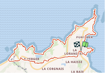
Randonnée Marche de 14,7 km à découvrir à Bretagne, Ille-et-Vilaine, Cancale. Cette randonnée est proposée par meunier.ph..
Description
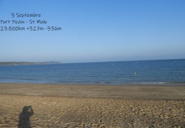
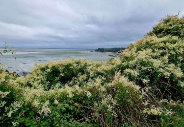
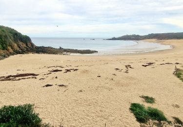
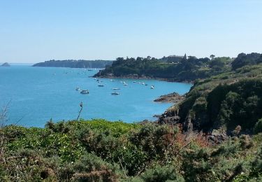
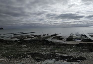
Boucle depuis le Port Picain. Sentier côtier par la pointe du Grouin jusqu'à l'île Du Guesclin puis retour par l'intérieure des terres.
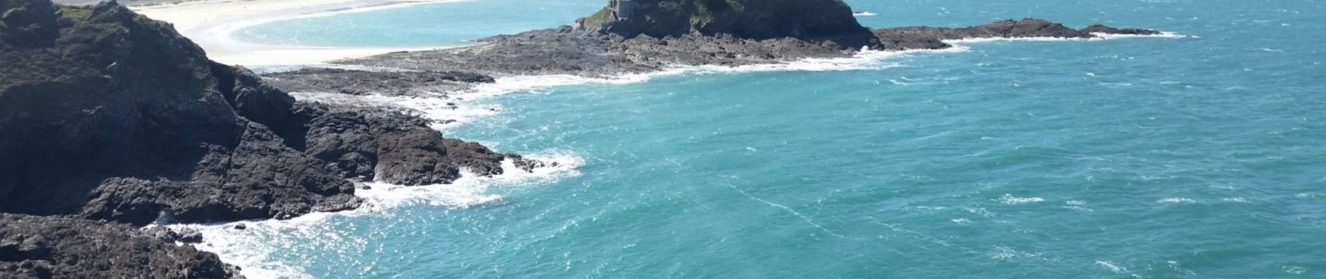
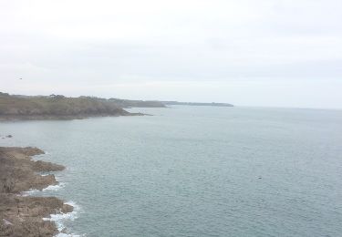
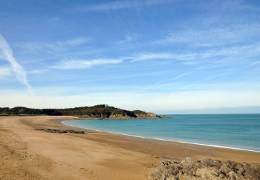
Jolie côte découpée avec de belles plages et criques.
Localisation
Pays :
France
Région :
Bretagne
Département/Province :
Ille-et-Vilaine
Commune :
Cancale
Localité :
Unknown
Départ:(Dec)
Départ:(UTM)
584448 ; 5394329 (30U) N.
Commentaires
Randonnées à proximité
![Randonnée Marche Cancale - cancale-pointe du grouin - Photo](https://media.geolcdn.com/t/375/260/ext.jpg?maxdim=2&url=https%3A%2F%2Fservices.sitytrail.com%2FGeolivesWS%2FDownloadMedia.ashx%3FTrailID%3D562635%26Media%3D20160502130406.jpg)
![Marche Marche](https://static1.geolcdn.com/sitytour/trail-icons/101.png)
cancale-pointe du grouin
Marche
Facile
(1)
Cancale,
Bretagne,
Ille-et-Vilaine,
France
![](/images/other/stat-length.png)
7,4 km | 9,1 km-effort
2h 12min
![](https://static1.geolcdn.com/siteimages/upload/files/16400158638029165_repeat_loop_refresh_sync_direction_icon.png)
Oui
![Randonnée Marche Cancale - Balade vers la Pointe du Grouin - Cancale - Photo](https://media.geolcdn.com/t/375/260/ext.jpg?maxdim=2&url=https%3A%2F%2Fservices.sitytrail.com%2FGeolivesWS%2FDownloadMedia.ashx%3FTrailID%3D317635%26Media%3D16903_4.jpg)
![Marche Marche](https://static1.geolcdn.com/sitytour/trail-icons/101.png)
Balade vers la Pointe du Grouin - Cancale
Marche
Moyen
(4)
Cancale,
Bretagne,
Ille-et-Vilaine,
France
![](/images/other/stat-length.png)
13,2 km | 15,9 km-effort
3h 30min
![](https://static1.geolcdn.com/siteimages/upload/files/16400158638029165_repeat_loop_refresh_sync_direction_icon.png)
Oui
![Marche Marche](https://static1.geolcdn.com/sitytour/trail-icons/101.png)
N°4 GR34 Port Picain -- Saint Malo
Marche
Très difficile
Cancale,
Bretagne,
Ille-et-Vilaine,
France
![](/images/other/stat-length.png)
24 km | 28 km-effort
6h 24min
![](https://static1.geolcdn.com/siteimages/upload/files/16400158638029165_repeat_loop_refresh_sync_direction_icon.png)
Non
![Randonnée A pied Cancale - Balade rapide à Cancale (hors groupe) - Photo](https://media.geolcdn.com/t/375/260/8cca7f8b-f64f-48e7-9459-b60c481745c3.jpg&format=jpg&maxdim=2)
![A pied A pied](https://static1.geolcdn.com/sitytour/trail-icons/100.png)
Balade rapide à Cancale (hors groupe)
A pied
Facile
Cancale,
Bretagne,
Ille-et-Vilaine,
France
![](/images/other/stat-length.png)
6 km | 7,9 km-effort
1h 47min
![](https://static1.geolcdn.com/siteimages/upload/files/16400158638029165_repeat_loop_refresh_sync_direction_icon.png)
Oui
![Randonnée Marche Cancale - Boucle Anse du Guesclin - Photo](https://media.geolcdn.com/t/375/260/1d52cbbc-9ca2-4f7c-8936-3e1e451657b1.jpg&format=jpg&maxdim=2)
![Marche Marche](https://static1.geolcdn.com/sitytour/trail-icons/101.png)
Boucle Anse du Guesclin
Marche
Facile
Cancale,
Bretagne,
Ille-et-Vilaine,
France
![](/images/other/stat-length.png)
6,1 km | 7,2 km-effort
2h 0min
![](https://static1.geolcdn.com/siteimages/upload/files/16400158638029165_repeat_loop_refresh_sync_direction_icon.png)
Oui
![Randonnée Marche Cancale - Cancale - Port Mer - boucle 6 pointes - 15.3km 240m 5h00 - 2017 06 19 - Photo](https://media.geolcdn.com/t/375/260/a3e4f02b-7f79-4247-9c5f-7345570d1680.jpg&format=jpg&maxdim=2)
![Marche Marche](https://static1.geolcdn.com/sitytour/trail-icons/101.png)
Cancale - Port Mer - boucle 6 pointes - 15.3km 240m 5h00 - 2017 06 19
Marche
Facile
Cancale,
Bretagne,
Ille-et-Vilaine,
France
![](/images/other/stat-length.png)
15,3 km | 18,5 km-effort
5h 0min
![](https://static1.geolcdn.com/siteimages/upload/files/16400158638029165_repeat_loop_refresh_sync_direction_icon.png)
Oui
![Randonnée Marche nordique Cancale - TOUR DE BZH ETAPE 1 J N°2 - Photo](https://media.geolcdn.com/t/375/260/ext.jpg?maxdim=2&url=https%3A%2F%2Fstatic1.geolcdn.com%2Fsiteimages%2Fupload%2Ffiles%2F1545311037marcheuse_200dpi.jpg)
![Marche nordique Marche nordique](https://static1.geolcdn.com/sitytour/trail-icons/102.png)
TOUR DE BZH ETAPE 1 J N°2
Marche nordique
Très facile
(1)
Cancale,
Bretagne,
Ille-et-Vilaine,
France
![](/images/other/stat-length.png)
15,8 km | 18,7 km-effort
3h 19min
![](https://static1.geolcdn.com/siteimages/upload/files/16400158638029165_repeat_loop_refresh_sync_direction_icon.png)
Non
![Randonnée Autre activité Cancale - Draft _ Pointe du Grouin court - Photo](https://media.geolcdn.com/t/375/260/ext.jpg?maxdim=2&url=https%3A%2F%2Fstatic1.geolcdn.com%2Fsiteimages%2Fupload%2Ffiles%2F1545311037marcheuse_200dpi.jpg)
![Autre activité Autre activité](https://static1.geolcdn.com/sitytour/trail-icons/900.png)
Draft _ Pointe du Grouin court
Autre activité
Très facile
(1)
Cancale,
Bretagne,
Ille-et-Vilaine,
France
![](/images/other/stat-length.png)
9 km | 11,1 km-effort
2h 0min
![](https://static1.geolcdn.com/siteimages/upload/files/16400158638029165_repeat_loop_refresh_sync_direction_icon.png)
Oui
![Randonnée Marche Cancale - 2024-03-19 boucle Cancale - Photo](https://media.geolcdn.com/t/375/260/67015cb6-a876-416e-8bce-1c916afa0c03.jpg&format=jpg&maxdim=2)
![Marche Marche](https://static1.geolcdn.com/sitytour/trail-icons/101.png)
2024-03-19 boucle Cancale
Marche
Moyen
Cancale,
Bretagne,
Ille-et-Vilaine,
France
![](/images/other/stat-length.png)
9,7 km | 12 km-effort
2h 25min
![](https://static1.geolcdn.com/siteimages/upload/files/16400158638029165_repeat_loop_refresh_sync_direction_icon.png)
Oui