![](/images/other/stat-length.png)
![Randonnée A pied Charleroi - Ravel - Hallage - Terrils - Photo](https://media.geolcdn.com/t/1900/400/ed7a79f4-ebef-4632-bf70-46dcd4aa35bf.jpg&format=pjpeg&maxdim=2)
Ravel - Hallage - Terrils
jenneval
Utilisateur
![Longueur](/images/other/stat-length.png)
Longueur
12,6 km
![Altitude max](https://static1.geolcdn.com/siteimages/upload/files/1508320355ic_sort_altitude_max_24dp.png)
Altitude max
165 m
![Dénivelé positif](https://static1.geolcdn.com/siteimages/upload/files/1508320355ic_sort_den_pos_24dp.png)
Dénivelé positif
174 m
![Km-Effort](/images/other/stat-length.png)
Km-Effort
14,9 km
![Altitude min](https://static1.geolcdn.com/siteimages/upload/files/1508320355ic_sort_altitude_min_24dp.png)
Altitude min
96 m
![Dénivelé négatif](https://static1.geolcdn.com/siteimages/upload/files/1508320355ic_sort_den_neg_24dp.png)
Dénivelé négatif
173 m
![Boucle](https://static1.geolcdn.com/siteimages/upload/files/16400158638029165_repeat_loop_refresh_sync_direction_icon.png)
Boucle
Oui
Date de création :
2021-03-13 09:40:30.391
Dernière modification :
2021-03-13 09:46:27.017
![A pied](https://static1.geolcdn.com/sitytour/trail-icons/100.png)
3h23
Difficulté : Facile
![Scannez ce code QR pour ouvrir la randonnée dans l'application SityTrail](https://capi.geolives.com/qq0zvz2zws4bq2lad0pu/sitytour/trails/2705354/qr.png?size=200)
Application GPS de randonnée GRATUITE
À propos
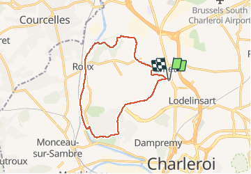
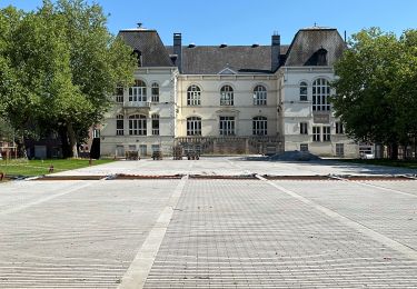
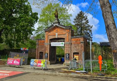
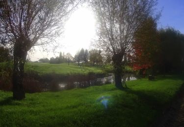
Randonnée A pied de 12,6 km à découvrir à Wallonie, Hainaut, Charleroi. Cette randonnée est proposée par jenneval.
Description
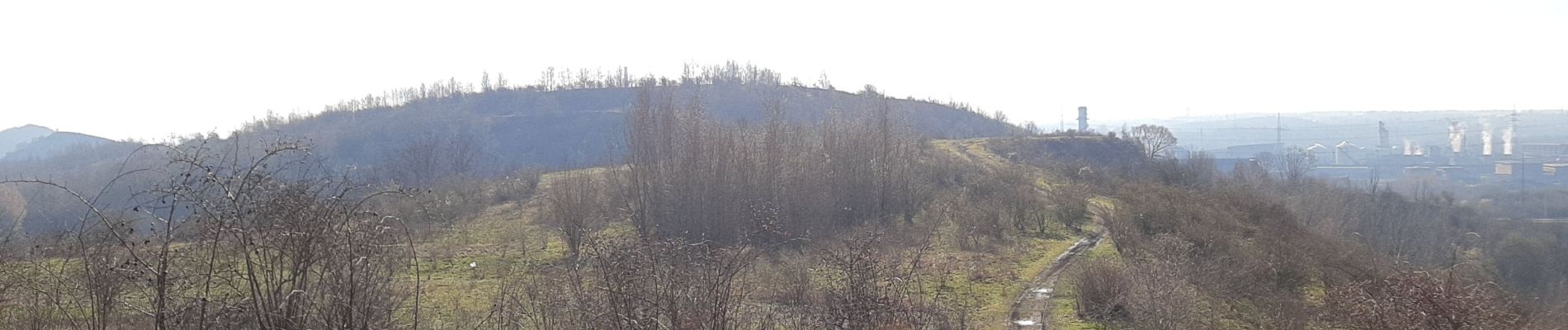
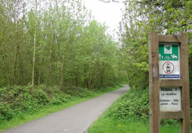
Une belle descente de Jumet vers Roux et son canal. Découverte du terril d'Heigne et Baillemont St Charles.
Pour plus de découverte allez voir mes autres randonnées.
Localisation
Pays :
Belgique
Région :
Wallonie
Département/Province :
Hainaut
Commune :
Charleroi
Localité :
Jumet
Départ:(Dec)
Départ:(UTM)
602088 ; 5588351 (31U) N.
Commentaires
Randonnées à proximité
![Randonnée Marche Charleroi - Balade de Marchienne-au-Pont à Charleroi - Photo](https://media.geolcdn.com/t/375/260/ext.jpg?maxdim=2&url=https%3A%2F%2Fservices.sitytrail.com%2FGeolivesWS%2FDownloadMedia.ashx%3FTrailID%3D949334%26Media%3D4dded785-5147-47ae-8985-edbbb0a17b68.jpg)
![Marche Marche](https://static1.geolcdn.com/sitytour/trail-icons/101.png)
Balade de Marchienne-au-Pont à Charleroi
Marche
Moyen
(3)
Charleroi,
Wallonie,
Hainaut,
Belgique
![](/images/other/stat-length.png)
12,8 km | 15,8 km-effort
3h 23min
![](https://static1.geolcdn.com/siteimages/upload/files/16400158638029165_repeat_loop_refresh_sync_direction_icon.png)
Oui
![Randonnée Marche Charleroi - La Promenade du Bois de Heigne - Photo](https://media.geolcdn.com/t/375/260/ext.jpg?maxdim=2&url=https%3A%2F%2Fservices.sitytrail.com%2FGeolivesWS%2FDownloadMedia.ashx%3FTrailID%3D419300%26Media%3Db1ae43a6-9bf7-4bbd-ae97-fe657cf31244.JPG)
![Marche Marche](https://static1.geolcdn.com/sitytour/trail-icons/101.png)
La Promenade du Bois de Heigne
Marche
Très facile
(4)
Charleroi,
Wallonie,
Hainaut,
Belgique
![](/images/other/stat-length.png)
6,8 km | 8,5 km-effort
1h 52min
![](https://static1.geolcdn.com/siteimages/upload/files/16400158638029165_repeat_loop_refresh_sync_direction_icon.png)
Oui
![Randonnée Marche Charleroi - Balade à Monceau-sur-Sambre - Photo](https://media.geolcdn.com/t/375/260/ext.jpg?maxdim=2&url=https%3A%2F%2Fservices.sitytrail.com%2FGeolivesWS%2FDownloadMedia.ashx%3FTrailID%3D333133%26Media%3D8178f634-f079-4d05-944b-2b2fb0f50083.JPG)
![Marche Marche](https://static1.geolcdn.com/sitytour/trail-icons/101.png)
Balade à Monceau-sur-Sambre
Marche
Très facile
(4)
Charleroi,
Wallonie,
Hainaut,
Belgique
![](/images/other/stat-length.png)
8,9 km | 10,7 km-effort
2h 21min
![](https://static1.geolcdn.com/siteimages/upload/files/16400158638029165_repeat_loop_refresh_sync_direction_icon.png)
Oui
![Randonnée Marche Charleroi - Terrils 1. dép rue chemin de fer,39.Marchienne - Photo](https://media.geolcdn.com/t/375/260/99108394-b48a-4f18-91eb-bf5bf6747a6b.jpg&format=jpg&maxdim=2)
![Marche Marche](https://static1.geolcdn.com/sitytour/trail-icons/101.png)
Terrils 1. dép rue chemin de fer,39.Marchienne
Marche
Difficile
(1)
Charleroi,
Wallonie,
Hainaut,
Belgique
![](/images/other/stat-length.png)
5,1 km | 6,4 km-effort
1h 43min
![](https://static1.geolcdn.com/siteimages/upload/files/16400158638029165_repeat_loop_refresh_sync_direction_icon.png)
Oui
![Randonnée Marche Charleroi - Balade sur le terril de l'Epine à Montignies-sur-Sambre - Photo](https://media.geolcdn.com/t/375/260/ext.jpg?maxdim=2&url=https%3A%2F%2Fstatic1.geolcdn.com%2Fsiteimages%2Fupload%2Ffiles%2F1553511878bg_sport_marche.png)
![Marche Marche](https://static1.geolcdn.com/sitytour/trail-icons/101.png)
Balade sur le terril de l'Epine à Montignies-sur-Sambre
Marche
Facile
(1)
Charleroi,
Wallonie,
Hainaut,
Belgique
![](/images/other/stat-length.png)
3,3 km | 4,3 km-effort
1h 0min
![](https://static1.geolcdn.com/siteimages/upload/files/16400158638029165_repeat_loop_refresh_sync_direction_icon.png)
Oui
![Randonnée Marche Charleroi - Promenade dans le Parc du Château de Monceau-sur-Sambre - Photo](https://media.geolcdn.com/t/375/260/ext.jpg?maxdim=2&url=https%3A%2F%2Fstatic1.geolcdn.com%2Fsiteimages%2Fupload%2Ffiles%2F1553511878bg_sport_marche.png)
![Marche Marche](https://static1.geolcdn.com/sitytour/trail-icons/101.png)
Promenade dans le Parc du Château de Monceau-sur-Sambre
Marche
Très facile
(2)
Charleroi,
Wallonie,
Hainaut,
Belgique
![](/images/other/stat-length.png)
4,3 km | 5,2 km-effort
1h 20min
![](https://static1.geolcdn.com/siteimages/upload/files/16400158638029165_repeat_loop_refresh_sync_direction_icon.png)
Oui
![Randonnée Marche Charleroi - Gr1666 1ere Roux -Montignie sur Sambre 26 km - Photo](https://media.geolcdn.com/t/375/260/c89e2fd3-064d-4b99-bfa7-7777a926978d.jpg&format=jpg&maxdim=2)
![Marche Marche](https://static1.geolcdn.com/sitytour/trail-icons/101.png)
Gr1666 1ere Roux -Montignie sur Sambre 26 km
Marche
Moyen
Charleroi,
Wallonie,
Hainaut,
Belgique
![](/images/other/stat-length.png)
25 km | 29 km-effort
7h 9min
![](https://static1.geolcdn.com/siteimages/upload/files/16400158638029165_repeat_loop_refresh_sync_direction_icon.png)
Non
![Randonnée Marche Châtelet - Marche Adeps à Soleilmont - Photo](https://media.geolcdn.com/t/375/260/9e6b3bd3-f2ef-4166-9fa1-430f6d99717e.jpeg&format=jpg&maxdim=2)
![Marche Marche](https://static1.geolcdn.com/sitytour/trail-icons/101.png)
Marche Adeps à Soleilmont
Marche
Moyen
Châtelet,
Wallonie,
Hainaut,
Belgique
![](/images/other/stat-length.png)
9,9 km | 11,8 km-effort
2h 41min
![](https://static1.geolcdn.com/siteimages/upload/files/16400158638029165_repeat_loop_refresh_sync_direction_icon.png)
Oui
![V.T.T. V.T.T.](https://static1.geolcdn.com/sitytour/trail-icons/202.png)
la sortie VTT des Gais lurons sur Ransart
V.T.T.
Très difficile
Charleroi,
Wallonie,
Hainaut,
Belgique
![](/images/other/stat-length.png)
54 km | 60 km-effort
4h 8min
![](https://static1.geolcdn.com/siteimages/upload/files/16400158638029165_repeat_loop_refresh_sync_direction_icon.png)
Oui