![](/images/other/stat-length.png)
![Randonnée Autre activité Walschbronn - Ecureuils 26 avril 2014 - Photo](https://media.geolcdn.com/t/1900/400/ext.pjpeg?maxdim=2&url=https%3A%2F%2Fstatic1.geolcdn.com%2Fsiteimages%2Fupload%2Ffiles%2F1545311037marcheuse_200dpi.jpg)
Ecureuils 26 avril 2014
lucienp
Utilisateur
![Longueur](/images/other/stat-length.png)
Longueur
14,4 km
![Altitude max](https://static1.geolcdn.com/siteimages/upload/files/1508320355ic_sort_altitude_max_24dp.png)
Altitude max
301 m
![Dénivelé positif](https://static1.geolcdn.com/siteimages/upload/files/1508320355ic_sort_den_pos_24dp.png)
Dénivelé positif
208 m
![Km-Effort](/images/other/stat-length.png)
Km-Effort
17,2 km
![Altitude min](https://static1.geolcdn.com/siteimages/upload/files/1508320355ic_sort_altitude_min_24dp.png)
Altitude min
250 m
![Dénivelé négatif](https://static1.geolcdn.com/siteimages/upload/files/1508320355ic_sort_den_neg_24dp.png)
Dénivelé négatif
209 m
![Boucle](https://static1.geolcdn.com/siteimages/upload/files/16400158638029165_repeat_loop_refresh_sync_direction_icon.png)
Boucle
Oui
Date de création :
2014-12-10 00:00:00.0
Dernière modification :
2014-12-10 00:00:00.0
![Autre activité](https://static1.geolcdn.com/sitytour/trail-icons/900.png)
2h00
Difficulté : Facile
![Scannez ce code QR pour ouvrir la randonnée dans l'application SityTrail](https://capi.geolives.com/qq0zvz2zws4bq2lad0pu/sitytour/trails/270390/qr.png?size=200)
Application GPS de randonnée GRATUITE
À propos
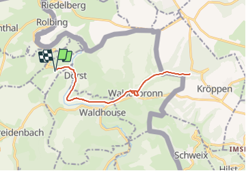
Randonnée Autre activité de 14,4 km à découvrir à Grand Est, Moselle, Walschbronn. Cette randonnée est proposée par lucienp.
Description
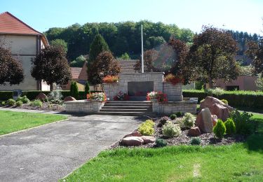
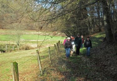
Sortie du 26 avril 2014, groupe Ecureuils de l'école cyclo de Bitche.
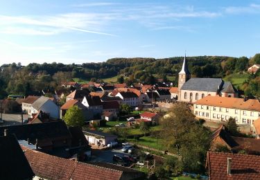
Visite de l'ancien château de Walschbronn et chasse au oeufs à Hexenfelsen
Localisation
Pays :
France
Région :
Grand Est
Département/Province :
Moselle
Commune :
Walschbronn
Localité :
Unknown
Départ:(Dec)
Départ:(UTM)
386421 ; 5445997 (32U) N.
Commentaires
Randonnées à proximité
![Randonnée A pied Walschbronn - Anneau bleu - Photo](https://media.geolcdn.com/t/375/260/70df8705-fd05-4999-bdfc-2508ac6b9e15.jpeg&format=jpg&maxdim=2)
![A pied A pied](https://static1.geolcdn.com/sitytour/trail-icons/100.png)
![Randonnée A pied Schweix - Anneau rouge - Photo](https://media.geolcdn.com/t/375/260/5ef45392-b749-445c-a602-485042878f58.jpeg&format=jpg&maxdim=2)
![A pied A pied](https://static1.geolcdn.com/sitytour/trail-icons/100.png)
Anneau rouge
A pied
Facile
Schweix,
Rhénanie-Palatinat,
Südwestpfalz,
Allemagne
![](/images/other/stat-length.png)
11,6 km | 14,3 km-effort
3h 15min
![](https://static1.geolcdn.com/siteimages/upload/files/16400158638029165_repeat_loop_refresh_sync_direction_icon.png)
Oui
![Randonnée Marche Liederschiedt - Le Sentier des Roches à Liederschiedt - Photo](https://media.geolcdn.com/t/375/260/af420eb2-af54-4d1d-a556-ec096faf6265.jpg&format=jpg&maxdim=2)
![Marche Marche](https://static1.geolcdn.com/sitytour/trail-icons/101.png)
Le Sentier des Roches à Liederschiedt
Marche
Moyen
Liederschiedt,
Grand Est,
Moselle,
France
![](/images/other/stat-length.png)
6,1 km | 8,6 km-effort
1h 57min
![](https://static1.geolcdn.com/siteimages/upload/files/16400158638029165_repeat_loop_refresh_sync_direction_icon.png)
Oui
![Randonnée Marche Bousseviller - De Bousseviller à Eberbach - Photo](https://media.geolcdn.com/t/375/260/ext.jpg?maxdim=2&url=https%3A%2F%2Fservices.sitytrail.com%2FGeolivesWS%2FDownloadMedia.ashx%3FTrailID%3D317560%26Media%3D16816_6.jpg)
![Marche Marche](https://static1.geolcdn.com/sitytour/trail-icons/101.png)
De Bousseviller à Eberbach
Marche
Moyen
Bousseviller,
Grand Est,
Moselle,
France
![](/images/other/stat-length.png)
13,1 km | 17,7 km-effort
3h 19min
![](https://static1.geolcdn.com/siteimages/upload/files/16400158638029165_repeat_loop_refresh_sync_direction_icon.png)
Oui
![Randonnée Marche Waldhouse - sentier d'excellence transfrontalier - Photo](https://media.geolcdn.com/t/375/260/ext.jpg?maxdim=2&url=https%3A%2F%2Fstatic1.geolcdn.com%2Fsiteimages%2Fupload%2Ffiles%2F1553511878bg_sport_marche.png)
![Marche Marche](https://static1.geolcdn.com/sitytour/trail-icons/101.png)
sentier d'excellence transfrontalier
Marche
Moyen
Waldhouse,
Grand Est,
Moselle,
France
![](/images/other/stat-length.png)
11,9 km | 15 km-effort
2h 10min
![](https://static1.geolcdn.com/siteimages/upload/files/16400158638029165_repeat_loop_refresh_sync_direction_icon.png)
Non
![Randonnée Marche Schweix - liederscbied - Photo](https://media.geolcdn.com/t/375/260/ext.jpg?maxdim=2&url=https%3A%2F%2Fstatic1.geolcdn.com%2Fsiteimages%2Fupload%2Ffiles%2F1553511878bg_sport_marche.png)
![Marche Marche](https://static1.geolcdn.com/sitytour/trail-icons/101.png)
liederscbied
Marche
Moyen
Schweix,
Rhénanie-Palatinat,
Südwestpfalz,
Allemagne
![](/images/other/stat-length.png)
9 km | 11,5 km-effort
2h 45min
![](https://static1.geolcdn.com/siteimages/upload/files/16400158638029165_repeat_loop_refresh_sync_direction_icon.png)
Oui
![Randonnée Vélo Walschbronn - parcours didier route aprem - Photo](https://media.geolcdn.com/t/375/260/ext.jpg?maxdim=2&url=https%3A%2F%2Fstatic1.geolcdn.com%2Fsiteimages%2Fupload%2Ffiles%2F1524743154velo.jpg)
![Vélo Vélo](https://static1.geolcdn.com/sitytour/trail-icons/200.png)
parcours didier route aprem
Vélo
Très facile
Walschbronn,
Grand Est,
Moselle,
France
![](/images/other/stat-length.png)
33 km | 40 km-effort
2h 17min
![](https://static1.geolcdn.com/siteimages/upload/files/16400158638029165_repeat_loop_refresh_sync_direction_icon.png)
Oui
![Randonnée V.T.T. Walschbronn - Matin grands 09.06.2018 - Photo](https://media.geolcdn.com/t/375/260/ext.jpg?maxdim=2&url=https%3A%2F%2Fstatic1.geolcdn.com%2Fsiteimages%2Fupload%2Ffiles%2F1524743154velo.jpg)
![V.T.T. V.T.T.](https://static1.geolcdn.com/sitytour/trail-icons/202.png)
Matin grands 09.06.2018
V.T.T.
Très facile
Walschbronn,
Grand Est,
Moselle,
France
![](/images/other/stat-length.png)
13,7 km | 17,9 km-effort
1h 12min
![](https://static1.geolcdn.com/siteimages/upload/files/16400158638029165_repeat_loop_refresh_sync_direction_icon.png)
Oui
![Randonnée V.T.T. Walschbronn - matin petits 09.06.2018 - Photo](https://media.geolcdn.com/t/375/260/ext.jpg?maxdim=2&url=https%3A%2F%2Fstatic1.geolcdn.com%2Fsiteimages%2Fupload%2Ffiles%2F1524743154velo.jpg)
![V.T.T. V.T.T.](https://static1.geolcdn.com/sitytour/trail-icons/202.png)
matin petits 09.06.2018
V.T.T.
Très facile
Walschbronn,
Grand Est,
Moselle,
France
![](/images/other/stat-length.png)
5,9 km | 7,2 km-effort
34min
![](https://static1.geolcdn.com/siteimages/upload/files/16400158638029165_repeat_loop_refresh_sync_direction_icon.png)
Oui