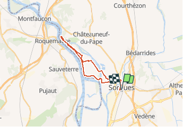
![](/images/other/stat-length.png)
![Randonnée Vélo Sorgues - ile de l'oiselet - Photo](https://media.geolcdn.com/t/1900/400/ext.pjpeg?maxdim=2&url=https%3A%2F%2Fstatic1.geolcdn.com%2Fsiteimages%2Fupload%2Ffiles%2F1524743154velo.jpg)
ile de l'oiselet
FLORENSAC
Utilisateur
![Longueur](/images/other/stat-length.png)
![Altitude max](https://static1.geolcdn.com/siteimages/upload/files/1508320355ic_sort_altitude_max_24dp.png)
![Dénivelé positif](https://static1.geolcdn.com/siteimages/upload/files/1508320355ic_sort_den_pos_24dp.png)
![Km-Effort](/images/other/stat-length.png)
![Altitude min](https://static1.geolcdn.com/siteimages/upload/files/1508320355ic_sort_altitude_min_24dp.png)
![Dénivelé négatif](https://static1.geolcdn.com/siteimages/upload/files/1508320355ic_sort_den_neg_24dp.png)
![Boucle](https://static1.geolcdn.com/siteimages/upload/files/16400158638029165_repeat_loop_refresh_sync_direction_icon.png)
![Vélo](https://static1.geolcdn.com/sitytour/trail-icons/200.png)
--
Difficulté : Très facile
![Scannez ce code QR pour ouvrir la randonnée dans l'application SityTrail](https://capi.geolives.com/qq0zvz2zws4bq2lad0pu/sitytour/trails/2700666/qr.png?size=200)
Application GPS de randonnée GRATUITE
À propos
Randonnée Vélo de 23 km à découvrir à Provence-Alpes-Côte d'Azur, Vaucluse, Sorgues. Cette randonnée est proposée par FLORENSAC.
Description
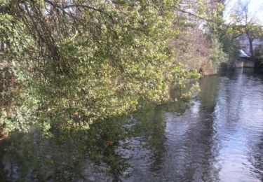
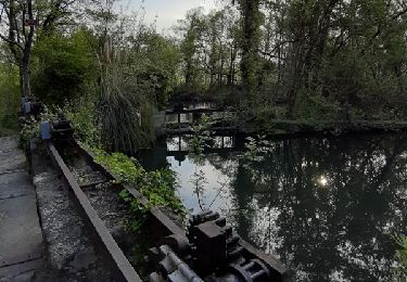
joli parcours sur l ile de l'Oiselet
pas de difficultés particulières, nous avons longé le bras du Rhône
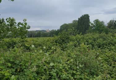
en bordure de champs cultivés , il doit y faire chaud l'été
penser à prendre à boire
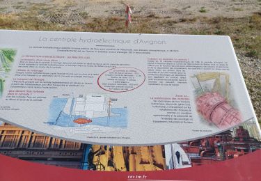
nous sommes allés jusqu'au chateau de l HERS, nous voulions faire une boucle , mais après le chateau de l Hers il a fallut faire demi tour
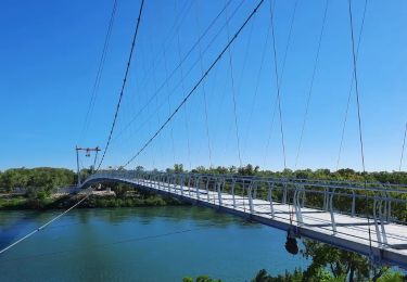
On ne pouvait pas passer avec les vélos , mais a pied oui
(note pour les randonneurs)
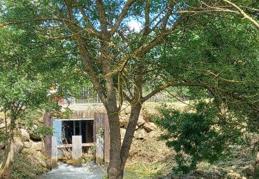
une jolie piste en cours de travaux
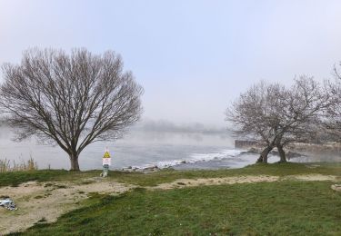
on aperçoit l'ancien pont des armeniers (interdit )
c 'est sympa a faire avec les enfants (pas beaucoup de monde de ce côté
(mais un peu monotone )
Localisation
Commentaires
Randonnées à proximité
![Randonnée Vélo Châteauneuf-du-Pape - Circuit Vélo - Le Vignoble de Châteauneuf du Pape - Photo](https://media.geolcdn.com/t/375/260/ext.jpg?maxdim=2&url=https%3A%2F%2Fservices.sitytrail.com%2FGeolivesWS%2FDownloadMedia.ashx%3FTrailID%3D111828%26Media%3D8517_2.jpg)
![Vélo Vélo](https://static1.geolcdn.com/sitytour/trail-icons/200.png)
Vélo
![](/images/other/stat-length.png)
![](https://static1.geolcdn.com/siteimages/upload/files/16400158638029165_repeat_loop_refresh_sync_direction_icon.png)
![Randonnée Marche Sorgues - La Montagnette Sorgues - Photo](https://media.geolcdn.com/t/375/260/ext.jpg?maxdim=2&url=https%3A%2F%2Fstatic1.geolcdn.com%2Fsiteimages%2Fupload%2Ffiles%2F1553511878bg_sport_marche.png)
![Marche Marche](https://static1.geolcdn.com/sitytour/trail-icons/101.png)
Marche
![](/images/other/stat-length.png)
![](https://static1.geolcdn.com/siteimages/upload/files/16400158638029165_repeat_loop_refresh_sync_direction_icon.png)
![Randonnée Marche Entraigues-sur-la-Sorgue - Balade à Entraigues sur la sorgue - Photo](https://media.geolcdn.com/t/375/260/ext.jpg?maxdim=2&url=https%3A%2F%2Fstatic1.geolcdn.com%2Fsiteimages%2Fupload%2Ffiles%2F1553511878bg_sport_marche.png)
![Marche Marche](https://static1.geolcdn.com/sitytour/trail-icons/101.png)
Marche
![](/images/other/stat-length.png)
![](https://static1.geolcdn.com/siteimages/upload/files/16400158638029165_repeat_loop_refresh_sync_direction_icon.png)
![Randonnée Course à pied Le Pontet - Le Pontet - Photo](https://media.geolcdn.com/t/375/260/12075d35-a7fc-4605-a13a-ec9078e8b636.jpg&format=jpg&maxdim=2)
![Course à pied Course à pied](https://static1.geolcdn.com/sitytour/trail-icons/103.png)
Course à pied
![](/images/other/stat-length.png)
![](https://static1.geolcdn.com/siteimages/upload/files/16400158638029165_repeat_loop_refresh_sync_direction_icon.png)
![Randonnée Marche Sorgues - L'oiselet tour de l'Hers par Via Rhona - Photo](https://media.geolcdn.com/t/375/260/ae795404-8df2-41e3-b94b-8aa983ef9544.jpg&format=jpg&maxdim=2)
![Marche Marche](https://static1.geolcdn.com/sitytour/trail-icons/101.png)
Marche
![](/images/other/stat-length.png)
![](https://static1.geolcdn.com/siteimages/upload/files/16400158638029165_repeat_loop_refresh_sync_direction_icon.png)
![Randonnée Marche Entraigues-sur-la-Sorgue - BALLADE AUTOUR D ENTRAIGUES SUR LA SORGUE , ECLUSES ET CASCADE - Photo](https://media.geolcdn.com/t/375/260/ee798285-fef1-41c7-b8ad-acf2df985316.jpg&format=jpg&maxdim=2)
![Marche Marche](https://static1.geolcdn.com/sitytour/trail-icons/101.png)
Marche
![](/images/other/stat-length.png)
![](https://static1.geolcdn.com/siteimages/upload/files/16400158638029165_repeat_loop_refresh_sync_direction_icon.png)
![Randonnée Marche Sorgues - PF-Sorgues - L'Ile de l'Oiselet - Passerelle himalayenne - XA - Photo](https://media.geolcdn.com/t/375/260/4f2a5ca5-0160-4735-ace4-9024c1196832.jpeg&format=jpg&maxdim=2)
![Marche Marche](https://static1.geolcdn.com/sitytour/trail-icons/101.png)
Marche
![](/images/other/stat-length.png)
![](https://static1.geolcdn.com/siteimages/upload/files/16400158638029165_repeat_loop_refresh_sync_direction_icon.png)
![Randonnée Marche Sauveterre - 2024-05-04 l'Oiselet - Photo](https://media.geolcdn.com/t/375/260/abfbac12-21a5-4fcb-99be-7af0fd741d69.jpg&format=jpg&maxdim=2)
![Marche Marche](https://static1.geolcdn.com/sitytour/trail-icons/101.png)
Marche
![](/images/other/stat-length.png)
![](https://static1.geolcdn.com/siteimages/upload/files/16400158638029165_repeat_loop_refresh_sync_direction_icon.png)
![Randonnée Marche Villeneuve-lès-Avignon - Villeneuve : Barrages et Iles - Photo](https://media.geolcdn.com/t/375/260/ca360c37-c773-4d85-895f-72b8b686fa79.jpg&format=jpg&maxdim=2)
![Marche Marche](https://static1.geolcdn.com/sitytour/trail-icons/101.png)
Marche
![](/images/other/stat-length.png)
![](https://static1.geolcdn.com/siteimages/upload/files/16400158638029165_repeat_loop_refresh_sync_direction_icon.png)