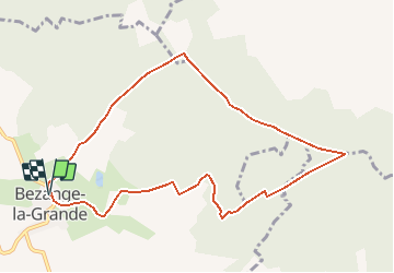
![](/images/other/stat-length.png)
![Randonnée Marche nordique Bezange-la-Grande - Bezange-la-Grande 9 170m +151m - Photo](https://media.geolcdn.com/t/1900/400/ext.pjpeg?maxdim=2&url=https%3A%2F%2Fstatic1.geolcdn.com%2Fsiteimages%2Fupload%2Ffiles%2F1545311037marcheuse_200dpi.jpg)
Bezange-la-Grande 9 170m +151m
DanielROLLET
Utilisateur
![Longueur](/images/other/stat-length.png)
Longueur
9,2 km
![Altitude max](https://static1.geolcdn.com/siteimages/upload/files/1508320355ic_sort_altitude_max_24dp.png)
Altitude max
322 m
![Dénivelé positif](https://static1.geolcdn.com/siteimages/upload/files/1508320355ic_sort_den_pos_24dp.png)
Dénivelé positif
151 m
![Km-Effort](/images/other/stat-length.png)
Km-Effort
11,2 km
![Altitude min](https://static1.geolcdn.com/siteimages/upload/files/1508320355ic_sort_altitude_min_24dp.png)
Altitude min
208 m
![Dénivelé négatif](https://static1.geolcdn.com/siteimages/upload/files/1508320355ic_sort_den_neg_24dp.png)
Dénivelé négatif
151 m
![Boucle](https://static1.geolcdn.com/siteimages/upload/files/16400158638029165_repeat_loop_refresh_sync_direction_icon.png)
Boucle
Oui
Date de création :
2021-03-08 08:30:59.183
Dernière modification :
2021-03-08 20:35:56.928
![Marche nordique](https://static1.geolcdn.com/sitytour/trail-icons/102.png)
2h00
Difficulté : Facile
![Scannez ce code QR pour ouvrir la randonnée dans l'application SityTrail](https://capi.geolives.com/qq0zvz2zws4bq2lad0pu/sitytour/trails/2700157/qr.png?size=200)
Application GPS de randonnée GRATUITE
À propos
Randonnée Marche nordique de 9,2 km à découvrir à Grand Est, Meurthe-et-Moselle, Bezange-la-Grande. Cette randonnée est proposée par DanielROLLET.
Description
2021 03 08 Marche nordique jonquilles - 14 personnes
Beau temps mais brise d'est
9h35 à 11h35
Nombreux arrêts
Localisation
Pays :
France
Région :
Grand Est
Département/Province :
Meurthe-et-Moselle
Commune :
Bezange-la-Grande
Localité :
Unknown
Départ:(Dec)
Départ:(UTM)
314365 ; 5402561 (32U) N.
Commentaires
Randonnées à proximité
![Randonnée Marche Hoéville - Bezange la grande - Photo](https://media.geolcdn.com/t/375/260/ext.jpg?maxdim=2&url=https%3A%2F%2Fmedia.geolcdn.com%2Ff%2F9b5cd856-989e-4277-b7db-cbc4b835c071.jpg)
![Marche Marche](https://static1.geolcdn.com/sitytour/trail-icons/101.png)
Bezange la grande
Marche
Moyen
Hoéville,
Grand Est,
Meurthe-et-Moselle,
France
![](/images/other/stat-length.png)
8,9 km | 11,2 km-effort
3h 1min
![](https://static1.geolcdn.com/siteimages/upload/files/16400158638029165_repeat_loop_refresh_sync_direction_icon.png)
Oui
![Randonnée Marche Vic-sur-Seille - Bezange la Grande - Photo](https://media.geolcdn.com/t/375/260/ext.jpg?maxdim=2&url=https%3A%2F%2Fmedia.geolcdn.com%2Ff%2F91dd1147-ecd0-4744-ad7a-8b13d84bd1ae.jpg)
![Marche Marche](https://static1.geolcdn.com/sitytour/trail-icons/101.png)
Bezange la Grande
Marche
Facile
Vic-sur-Seille,
Grand Est,
Moselle,
France
![](/images/other/stat-length.png)
11 km | 13,4 km-effort
2h 10min
![](https://static1.geolcdn.com/siteimages/upload/files/16400158638029165_repeat_loop_refresh_sync_direction_icon.png)
Oui
![Randonnée Marche Vic-sur-Seille - vic moyenvic par stade - Photo](https://media.geolcdn.com/t/375/260/ext.jpg?maxdim=2&url=https%3A%2F%2Fstatic1.geolcdn.com%2Fsiteimages%2Fupload%2Ffiles%2F1553511878bg_sport_marche.png)
![Marche Marche](https://static1.geolcdn.com/sitytour/trail-icons/101.png)
vic moyenvic par stade
Marche
Facile
Vic-sur-Seille,
Grand Est,
Moselle,
France
![](/images/other/stat-length.png)
4,2 km | 4,8 km-effort
54min
![](https://static1.geolcdn.com/siteimages/upload/files/16400158638029165_repeat_loop_refresh_sync_direction_icon.png)
Non
![Randonnée Marche nordique Hoéville - Hoeville 9 110m +161m - Photo](https://media.geolcdn.com/t/375/260/ext.jpg?maxdim=2&url=https%3A%2F%2Fstatic1.geolcdn.com%2Fsiteimages%2Fupload%2Ffiles%2F1545311037marcheuse_200dpi.jpg)
![Marche nordique Marche nordique](https://static1.geolcdn.com/sitytour/trail-icons/102.png)
Hoeville 9 110m +161m
Marche nordique
Facile
Hoéville,
Grand Est,
Meurthe-et-Moselle,
France
![](/images/other/stat-length.png)
9,1 km | 11,3 km-effort
2h 15min
![](https://static1.geolcdn.com/siteimages/upload/files/16400158638029165_repeat_loop_refresh_sync_direction_icon.png)
Oui
![Randonnée Marche Vic-sur-Seille - Vic sur Seille - Photo](https://media.geolcdn.com/t/375/260/ext.jpg?maxdim=2&url=https%3A%2F%2Fstatic1.geolcdn.com%2Fsiteimages%2Fupload%2Ffiles%2F1553511878bg_sport_marche.png)
![Marche Marche](https://static1.geolcdn.com/sitytour/trail-icons/101.png)
Vic sur Seille
Marche
Difficile
Vic-sur-Seille,
Grand Est,
Moselle,
France
![](/images/other/stat-length.png)
14,9 km | 18,3 km-effort
3h 0min
![](https://static1.geolcdn.com/siteimages/upload/files/16400158638029165_repeat_loop_refresh_sync_direction_icon.png)
Oui
![Randonnée Marche Sornéville - Sornéville_10km - Photo](https://media.geolcdn.com/t/375/260/ext.jpg?maxdim=2&url=https%3A%2F%2Fstatic1.geolcdn.com%2Fsiteimages%2Fupload%2Ffiles%2F1553511878bg_sport_marche.png)
![Marche Marche](https://static1.geolcdn.com/sitytour/trail-icons/101.png)
Sornéville_10km
Marche
Moyen
Sornéville,
Grand Est,
Meurthe-et-Moselle,
France
![](/images/other/stat-length.png)
9,7 km | 11,5 km-effort
2h 37min
![](https://static1.geolcdn.com/siteimages/upload/files/16400158638029165_repeat_loop_refresh_sync_direction_icon.png)
Oui
![Randonnée Marche Vic-sur-Seille - vic foyer - Photo](https://media.geolcdn.com/t/375/260/ext.jpg?maxdim=2&url=https%3A%2F%2Fstatic1.geolcdn.com%2Fsiteimages%2Fupload%2Ffiles%2F1553511878bg_sport_marche.png)
![Marche Marche](https://static1.geolcdn.com/sitytour/trail-icons/101.png)
vic foyer
Marche
Difficile
Vic-sur-Seille,
Grand Est,
Moselle,
France
![](/images/other/stat-length.png)
12,9 km | 16,4 km-effort
2h 52min
![](https://static1.geolcdn.com/siteimages/upload/files/16400158638029165_repeat_loop_refresh_sync_direction_icon.png)
Oui
![Randonnée Marche nordique Hoéville - Hoëville 10 360m +177m - Photo](https://media.geolcdn.com/t/375/260/ext.jpg?maxdim=2&url=https%3A%2F%2Fstatic1.geolcdn.com%2Fsiteimages%2Fupload%2Ffiles%2F1545311037marcheuse_200dpi.jpg)
![Marche nordique Marche nordique](https://static1.geolcdn.com/sitytour/trail-icons/102.png)
Hoëville 10 360m +177m
Marche nordique
Facile
Hoéville,
Grand Est,
Meurthe-et-Moselle,
France
![](/images/other/stat-length.png)
10,4 km | 12,7 km-effort
2h 25min
![](https://static1.geolcdn.com/siteimages/upload/files/16400158638029165_repeat_loop_refresh_sync_direction_icon.png)
Oui
![Randonnée Marche Hoéville - Hoeville_Roche des fées_16km - Photo](https://media.geolcdn.com/t/375/260/ext.jpg?maxdim=2&url=https%3A%2F%2Fstatic1.geolcdn.com%2Fsiteimages%2Fupload%2Ffiles%2F1553511878bg_sport_marche.png)
![Marche Marche](https://static1.geolcdn.com/sitytour/trail-icons/101.png)
Hoeville_Roche des fées_16km
Marche
Très difficile
Hoéville,
Grand Est,
Meurthe-et-Moselle,
France
![](/images/other/stat-length.png)
16,1 km | 20 km-effort
4h 20min
![](https://static1.geolcdn.com/siteimages/upload/files/16400158638029165_repeat_loop_refresh_sync_direction_icon.png)
Oui