![](/images/other/stat-length.png)
![Randonnée Marche Souraïde - Mont EREBI 583m. - Photo](https://media.geolcdn.com/t/1900/400/ext.pjpeg?maxdim=2&url=https%3A%2F%2Fstatic1.geolcdn.com%2Fsiteimages%2Fupload%2Ffiles%2F1553511878bg_sport_marche.png)
Mont EREBI 583m.
DECHAMPD
Utilisateur
![Longueur](/images/other/stat-length.png)
Longueur
13,5 km
![Altitude max](https://static1.geolcdn.com/siteimages/upload/files/1508320355ic_sort_altitude_max_24dp.png)
Altitude max
553 m
![Dénivelé positif](https://static1.geolcdn.com/siteimages/upload/files/1508320355ic_sort_den_pos_24dp.png)
Dénivelé positif
621 m
![Km-Effort](/images/other/stat-length.png)
Km-Effort
22 km
![Altitude min](https://static1.geolcdn.com/siteimages/upload/files/1508320355ic_sort_altitude_min_24dp.png)
Altitude min
192 m
![Dénivelé négatif](https://static1.geolcdn.com/siteimages/upload/files/1508320355ic_sort_den_neg_24dp.png)
Dénivelé négatif
622 m
![Boucle](https://static1.geolcdn.com/siteimages/upload/files/16400158638029165_repeat_loop_refresh_sync_direction_icon.png)
Boucle
Oui
Date de création :
2019-01-14 17:35:51.497
Dernière modification :
2019-01-14 17:35:51.573
![Marche](https://static1.geolcdn.com/sitytour/trail-icons/101.png)
5h40
Difficulté : Moyen
![Scannez ce code QR pour ouvrir la randonnée dans l'application SityTrail](https://capi.geolives.com/qq0zvz2zws4bq2lad0pu/sitytour/trails/269932/qr.png?size=200)
Application GPS de randonnée GRATUITE
À propos
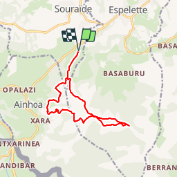
Randonnée Marche de 13,5 km à découvrir à Nouvelle-Aquitaine, Pyrénées-Atlantiques, Souraïde. Cette randonnée est proposée par DECHAMPD.
Description
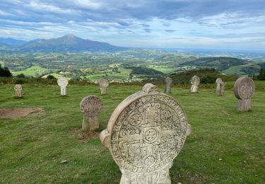
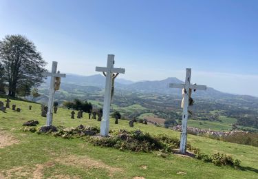
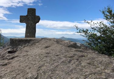
depuis le col dePINADIETA, Mendiondoa, la chapelle d'Arantze et le calvaire, le col des trois croix, le refuge Gainekoborda avec contour de l'Atzulegi, la face nord de l'Erebi par le GR10.
Points d'intérêt
Localisation
Pays :
France
Région :
Nouvelle-Aquitaine
Département/Province :
Pyrénées-Atlantiques
Commune :
Souraïde
Localité :
Unknown
Départ:(Dec)
Départ:(UTM)
623854 ; 4798177 (30T) N.
Commentaires
Randonnées à proximité
![Randonnée Marche Espelette - Erreka mondarain col des veaux - Photo](https://media.geolcdn.com/t/375/260/3df7f8f7-bc92-4579-aed0-3a855d972fe6.jpg&format=jpg&maxdim=2)
![Marche Marche](https://static1.geolcdn.com/sitytour/trail-icons/101.png)
Erreka mondarain col des veaux
Marche
Difficile
(1)
Espelette,
Nouvelle-Aquitaine,
Pyrénées-Atlantiques,
France
![](/images/other/stat-length.png)
18,3 km | 29 km-effort
6h 34min
![](https://static1.geolcdn.com/siteimages/upload/files/16400158638029165_repeat_loop_refresh_sync_direction_icon.png)
Oui
![Randonnée Course à pied Ainhoa - Ainhoa - L'Erebi - Photo](https://media.geolcdn.com/t/375/260/ext.jpg?maxdim=2&url=https%3A%2F%2Fservices.sitytrail.com%2FGeolivesWS%2FDownloadMedia.ashx%3FTrailID%3D105338%26Media%3D9037_5.jpg)
![Course à pied Course à pied](https://static1.geolcdn.com/sitytour/trail-icons/103.png)
Ainhoa - L'Erebi
Course à pied
Difficile
(1)
Ainhoa,
Nouvelle-Aquitaine,
Pyrénées-Atlantiques,
France
![](/images/other/stat-length.png)
9,3 km | 15,9 km-effort
1h 0min
![](https://static1.geolcdn.com/siteimages/upload/files/16400158638029165_repeat_loop_refresh_sync_direction_icon.png)
Oui
![Randonnée Marche Espelette - De la Nive à la Nivelle - Circuit des familles - Espelette - Photo](https://media.geolcdn.com/t/375/260/ext.jpg?maxdim=2&url=https%3A%2F%2Fservices.sitytrail.com%2FGeolivesWS%2FDownloadMedia.ashx%3FTrailID%3D111304%26Media%3D6953_1.jpg)
![Marche Marche](https://static1.geolcdn.com/sitytour/trail-icons/101.png)
De la Nive à la Nivelle - Circuit des familles - Espelette
Marche
Facile
(1)
Espelette,
Nouvelle-Aquitaine,
Pyrénées-Atlantiques,
France
![](/images/other/stat-length.png)
7,1 km | 9,2 km-effort
1h 30min
![](https://static1.geolcdn.com/siteimages/upload/files/16400158638029165_repeat_loop_refresh_sync_direction_icon.png)
Oui
![Randonnée Marche Espelette - ESPELETTE Le circuit des familles](https://media.geolcdn.com/t/375/260/9437414c-8a31-4a8c-95c7-86058d157002.jpg&format=jpg&maxdim=2)
![Marche Marche](https://static1.geolcdn.com/sitytour/trail-icons/101.png)
ESPELETTE Le circuit des familles "3850002"
Marche
Moyen
Espelette,
Nouvelle-Aquitaine,
Pyrénées-Atlantiques,
France
![](/images/other/stat-length.png)
7,5 km | 9,6 km-effort
1h 55min
![](https://static1.geolcdn.com/siteimages/upload/files/16400158638029165_repeat_loop_refresh_sync_direction_icon.png)
Oui
![Randonnée Marche Ainhoa - Ainhoa - Photo](https://media.geolcdn.com/t/375/260/ee1c7e91-f4e0-4f59-b063-549c67ea084e.jpg&format=jpg&maxdim=2)
![Marche Marche](https://static1.geolcdn.com/sitytour/trail-icons/101.png)
Ainhoa
Marche
Facile
Ainhoa,
Nouvelle-Aquitaine,
Pyrénées-Atlantiques,
France
![](/images/other/stat-length.png)
14,6 km | 23 km-effort
3h 48min
![](https://static1.geolcdn.com/siteimages/upload/files/16400158638029165_repeat_loop_refresh_sync_direction_icon.png)
Oui
![Randonnée Marche Ainhoa - AINHOA veille 2 la chapelle de l'aubepine](https://media.geolcdn.com/t/375/260/ea905ad0-c1b4-41cf-8e66-78fc467c8da8.jpg&format=jpg&maxdim=2)
![Marche Marche](https://static1.geolcdn.com/sitytour/trail-icons/101.png)
AINHOA veille 2 la chapelle de l'aubepine "4035277"
Marche
Difficile
Ainhoa,
Nouvelle-Aquitaine,
Pyrénées-Atlantiques,
France
![](/images/other/stat-length.png)
8,7 km | 14,4 km-effort
3h 16min
![](https://static1.geolcdn.com/siteimages/upload/files/16400158638029165_repeat_loop_refresh_sync_direction_icon.png)
Oui
![Randonnée Marche Ainhoa - Dantcheria gorospil col des croix erre il - Photo](https://media.geolcdn.com/t/375/260/5dc57095-42d8-40d9-8d91-50ef1ee955dd.jpg&format=jpg&maxdim=2)
![Marche Marche](https://static1.geolcdn.com/sitytour/trail-icons/101.png)
Dantcheria gorospil col des croix erre il
Marche
Moyen
Ainhoa,
Nouvelle-Aquitaine,
Pyrénées-Atlantiques,
France
![](/images/other/stat-length.png)
17,1 km | 28 km-effort
5h 25min
![](https://static1.geolcdn.com/siteimages/upload/files/16400158638029165_repeat_loop_refresh_sync_direction_icon.png)
Oui
![Randonnée Marche Espelette - Etxegaria col des veaux col des 3 croix - Photo](https://media.geolcdn.com/t/375/260/21062a3d-425b-4498-813b-33082b96e714.jpg&format=jpg&maxdim=2)
![Marche Marche](https://static1.geolcdn.com/sitytour/trail-icons/101.png)
Etxegaria col des veaux col des 3 croix
Marche
Moyen
Espelette,
Nouvelle-Aquitaine,
Pyrénées-Atlantiques,
France
![](/images/other/stat-length.png)
17,6 km | 27 km-effort
5h 17min
![](https://static1.geolcdn.com/siteimages/upload/files/16400158638029165_repeat_loop_refresh_sync_direction_icon.png)
Oui
![Randonnée Marche Espelette - 20210518 Pres d’Espelette - Photo](https://media.geolcdn.com/t/375/260/37a15aaf-024e-43cd-923a-b0411b970c4f.jpg&format=jpg&maxdim=2)
![Marche Marche](https://static1.geolcdn.com/sitytour/trail-icons/101.png)
20210518 Pres d’Espelette
Marche
Facile
Espelette,
Nouvelle-Aquitaine,
Pyrénées-Atlantiques,
France
![](/images/other/stat-length.png)
11,4 km | 18,6 km-effort
3h 34min
![](https://static1.geolcdn.com/siteimages/upload/files/16400158638029165_repeat_loop_refresh_sync_direction_icon.png)
Oui