![](/images/other/stat-length.png)
![Randonnée Marche Aywaille - Ernonheid _ GR _ IDEE RANDO 216 _ La vallée du Pouhon - Photo](https://media.geolcdn.com/t/1900/400/94875655-0710-4642-a7be-37511454b570.jpg&format=pjpeg&maxdim=2)
Ernonheid _ GR _ IDEE RANDO 216 _ La vallée du Pouhon
jeangulu
Utilisateur
![Longueur](/images/other/stat-length.png)
Longueur
21 km
![Altitude max](https://static1.geolcdn.com/siteimages/upload/files/1508320355ic_sort_altitude_max_24dp.png)
Altitude max
414 m
![Dénivelé positif](https://static1.geolcdn.com/siteimages/upload/files/1508320355ic_sort_den_pos_24dp.png)
Dénivelé positif
520 m
![Km-Effort](/images/other/stat-length.png)
Km-Effort
28 km
![Altitude min](https://static1.geolcdn.com/siteimages/upload/files/1508320355ic_sort_altitude_min_24dp.png)
Altitude min
236 m
![Dénivelé négatif](https://static1.geolcdn.com/siteimages/upload/files/1508320355ic_sort_den_neg_24dp.png)
Dénivelé négatif
519 m
![Boucle](https://static1.geolcdn.com/siteimages/upload/files/16400158638029165_repeat_loop_refresh_sync_direction_icon.png)
Boucle
Oui
Date de création :
2021-03-07 10:16:37.903
Dernière modification :
2021-03-08 08:37:55.635
![Marche](https://static1.geolcdn.com/sitytour/trail-icons/101.png)
5h47
Difficulté : Moyen
![Scannez ce code QR pour ouvrir la randonnée dans l'application SityTrail](https://capi.geolives.com/qq0zvz2zws4bq2lad0pu/sitytour/trails/2699049/qr.png?size=200)
Application GPS de randonnée GRATUITE
À propos
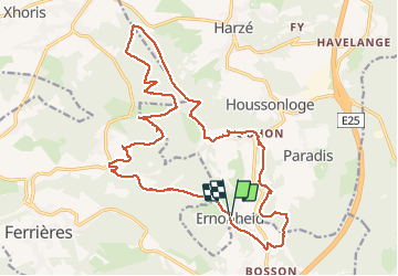
Randonnée Marche de 21 km à découvrir à Wallonie, Liège, Aywaille. Cette randonnée est proposée par jeangulu.
Description
Départ : Parking à côté de la salle 《 Al Vile Sicole 》
Au Cœur du Condroz Liégeois
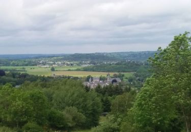
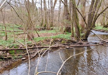
Très belle randonnée forestière le beau temps était présent super le parcours
Localisation
Pays :
Belgique
Région :
Wallonie
Département/Province :
Liège
Commune :
Aywaille
Localité :
Ernonheid
Départ:(Dec)
Départ:(UTM)
689483 ; 5586892 (31U) N.
Commentaires
Randonnées à proximité
![Randonnée Marche Stoumont - Lorcé, Natura 2000 - Des sites qui valent le détour, Lg13 - Photo](https://media.geolcdn.com/t/375/260/ext.jpg?maxdim=2&url=https%3A%2F%2Fservices.sitytrail.com%2FGeolivesWS%2FDownloadMedia.ashx%3FTrailID%3D182859%26Media%3D43b80b1e-327b-4d3e-accc-f8b9c8a445c2.JPG)
![Marche Marche](https://static1.geolcdn.com/sitytour/trail-icons/101.png)
Lorcé, Natura 2000 - Des sites qui valent le détour, Lg13
Marche
Facile
(7)
Stoumont,
Wallonie,
Liège,
Belgique
![](/images/other/stat-length.png)
6,1 km | 8,9 km-effort
1h 57min
![](https://static1.geolcdn.com/siteimages/upload/files/16400158638029165_repeat_loop_refresh_sync_direction_icon.png)
Oui
![Randonnée Marche Ferrières - Rouge-Minière. Natura 2000, des sites qui valent le détour ! Lg 3 - Photo](https://media.geolcdn.com/t/375/260/ext.jpg?maxdim=2&url=https%3A%2F%2Fservices.sitytrail.com%2FGeolivesWS%2FDownloadMedia.ashx%3FTrailID%3D142641%26Media%3Dc08233b4-27a6-486a-be6b-e1cb0ee623d1.JPG)
![Marche Marche](https://static1.geolcdn.com/sitytour/trail-icons/101.png)
Rouge-Minière. Natura 2000, des sites qui valent le détour ! Lg 3
Marche
Facile
(17)
Ferrières,
Wallonie,
Liège,
Belgique
![](/images/other/stat-length.png)
6,8 km | 8,9 km-effort
Inconnu
![](https://static1.geolcdn.com/siteimages/upload/files/16400158638029165_repeat_loop_refresh_sync_direction_icon.png)
Oui
![Randonnée Marche Stoumont - RB-Lg-14_Chevron_via-racc - Photo](https://media.geolcdn.com/t/375/260/ext.jpg?maxdim=2&url=https%3A%2F%2Fservices.sitytrail.com%2FGeolivesWS%2FDownloadMedia.ashx%3FTrailID%3D179572%26Media%3Ddd649bf1-a115-4c1e-9e23-c1a80ab51103.jpg)
![Marche Marche](https://static1.geolcdn.com/sitytour/trail-icons/101.png)
RB-Lg-14_Chevron_via-racc
Marche
Très difficile
(5)
Stoumont,
Wallonie,
Liège,
Belgique
![](/images/other/stat-length.png)
17 km | 24 km-effort
5h 28min
![](https://static1.geolcdn.com/siteimages/upload/files/16400158638029165_repeat_loop_refresh_sync_direction_icon.png)
Oui
![Randonnée Marche Aywaille - RB-Lg-15_Harzé - Photo](https://media.geolcdn.com/t/375/260/ext.jpg?maxdim=2&url=https%3A%2F%2Fservices.sitytrail.com%2FGeolivesWS%2FDownloadMedia.ashx%3FTrailID%3D179573%26Media%3D790acd11-a9eb-4644-bdd3-c1540608bba1.jpg)
![Marche Marche](https://static1.geolcdn.com/sitytour/trail-icons/101.png)
RB-Lg-15_Harzé
Marche
Difficile
(7)
Aywaille,
Wallonie,
Liège,
Belgique
![](/images/other/stat-length.png)
22 km | 30 km-effort
6h 10min
![](https://static1.geolcdn.com/siteimages/upload/files/16400158638029165_repeat_loop_refresh_sync_direction_icon.png)
Oui
![Randonnée Marche Stoumont - lorcé . suf la lienne . Chevron . lorcé - Photo](https://media.geolcdn.com/t/375/260/9599f201-d2ad-4521-ad0a-b4661e5a5ff4.jpg&format=jpg&maxdim=2)
![Marche Marche](https://static1.geolcdn.com/sitytour/trail-icons/101.png)
lorcé . suf la lienne . Chevron . lorcé
Marche
Très facile
(1)
Stoumont,
Wallonie,
Liège,
Belgique
![](/images/other/stat-length.png)
15,9 km | 22 km-effort
5h 41min
![](https://static1.geolcdn.com/siteimages/upload/files/16400158638029165_repeat_loop_refresh_sync_direction_icon.png)
Oui
![Randonnée Marche Aywaille - houssonloge . bois du pouhon . trou de bosson . paradis . houssonloge - Photo](https://media.geolcdn.com/t/375/260/8bc033a3-d4f5-4c9f-9bb4-a2d3fb614b59.jpg&format=jpg&maxdim=2)
![Marche Marche](https://static1.geolcdn.com/sitytour/trail-icons/101.png)
houssonloge . bois du pouhon . trou de bosson . paradis . houssonloge
Marche
Très facile
(4)
Aywaille,
Wallonie,
Liège,
Belgique
![](/images/other/stat-length.png)
9,1 km | 12,4 km-effort
2h 49min
![](https://static1.geolcdn.com/siteimages/upload/files/16400158638029165_repeat_loop_refresh_sync_direction_icon.png)
Oui
![Randonnée Marche Stoumont - RB-Lg-14_Chevron - Photo](https://media.geolcdn.com/t/375/260/ext.jpg?maxdim=2&url=https%3A%2F%2Fservices.sitytrail.com%2FGeolivesWS%2FDownloadMedia.ashx%3FTrailID%3D179572%26Media%3Ddd649bf1-a115-4c1e-9e23-c1a80ab51103.jpg)
![Marche Marche](https://static1.geolcdn.com/sitytour/trail-icons/101.png)
RB-Lg-14_Chevron
Marche
Très difficile
(4)
Stoumont,
Wallonie,
Liège,
Belgique
![](/images/other/stat-length.png)
22 km | 30 km-effort
6h 53min
![](https://static1.geolcdn.com/siteimages/upload/files/16400158638029165_repeat_loop_refresh_sync_direction_icon.png)
Oui
![Randonnée Marche Ferrières - Marche ADEPS BURNONTIGE (Ferrieres) 10/04/33 - Photo](https://media.geolcdn.com/t/375/260/6e9d890b-6b68-45d8-aaec-5de6224210eb.jpg&format=jpg&maxdim=2)
![Marche Marche](https://static1.geolcdn.com/sitytour/trail-icons/101.png)
Marche ADEPS BURNONTIGE (Ferrieres) 10/04/33
Marche
Moyen
(1)
Ferrières,
Wallonie,
Liège,
Belgique
![](/images/other/stat-length.png)
15,4 km | 20 km-effort
3h 2min
![](https://static1.geolcdn.com/siteimages/upload/files/16400158638029165_repeat_loop_refresh_sync_direction_icon.png)
Oui
![Randonnée Marche Stoumont - 10km sous la pluie autour de Lorcé - Photo](https://media.geolcdn.com/t/375/260/cbc0016a-dfca-4c73-9974-c42c5bf54007.jpg&format=jpg&maxdim=2)
![Marche Marche](https://static1.geolcdn.com/sitytour/trail-icons/101.png)
10km sous la pluie autour de Lorcé
Marche
Facile
(1)
Stoumont,
Wallonie,
Liège,
Belgique
![](/images/other/stat-length.png)
10,6 km | 14,1 km-effort
2h 47min
![](https://static1.geolcdn.com/siteimages/upload/files/16400158638029165_repeat_loop_refresh_sync_direction_icon.png)
Oui