![](/images/other/stat-length.png)
![Randonnée Raquettes à neige Valdeblore - Col du Barn - Photo](https://media.geolcdn.com/t/1900/400/a75f9aa7-28b8-49bf-a40b-41f56396a29c.jpg&format=pjpeg&maxdim=2)
Col du Barn
aris
Utilisateur
![Longueur](/images/other/stat-length.png)
![Altitude max](https://static1.geolcdn.com/siteimages/upload/files/1508320355ic_sort_altitude_max_24dp.png)
![Dénivelé positif](https://static1.geolcdn.com/siteimages/upload/files/1508320355ic_sort_den_pos_24dp.png)
![Km-Effort](/images/other/stat-length.png)
![Altitude min](https://static1.geolcdn.com/siteimages/upload/files/1508320355ic_sort_altitude_min_24dp.png)
![Dénivelé négatif](https://static1.geolcdn.com/siteimages/upload/files/1508320355ic_sort_den_neg_24dp.png)
![Boucle](https://static1.geolcdn.com/siteimages/upload/files/16400158638029165_repeat_loop_refresh_sync_direction_icon.png)
![Raquettes à neige](https://static1.geolcdn.com/sitytour/trail-icons/504.png)
7h49
Difficulté : Moyen
![Scannez ce code QR pour ouvrir la randonnée dans l'application SityTrail](https://capi.geolives.com/qq0zvz2zws4bq2lad0pu/sitytour/trails/2695902/qr.png?size=200)
Application GPS de randonnée GRATUITE
À propos
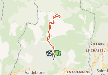
Randonnée Raquettes à neige de 11,9 km à découvrir à Provence-Alpes-Côte d'Azur, Alpes-Maritimes, Valdeblore. Cette randonnée est proposée par aris.
Description
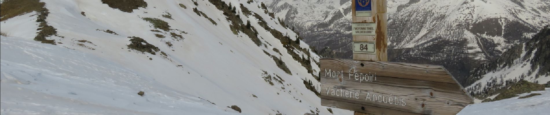
Laissé la voiture aux premières plaques de neige sur la route des Millefonts. Montée à pied jusqu'au col de Veillos, puis crampons pour la suite.
Montée en raquette possible, mais éviter la portion finale en dévert au dessus du lac Gros (prendre à gauche du lac par mon itinéraire de descente ; nombreuses traces de raquettes).
Localisation
Commentaires
Randonnées à proximité
![Randonnée Marche Valdeblore - pepoiri - Photo](https://media.geolcdn.com/t/375/260/8ca18259-e53b-4625-8dc3-3afb9e53eb6b.jpg&format=jpg&maxdim=2)
![Marche Marche](https://static1.geolcdn.com/sitytour/trail-icons/101.png)
Marche
![](/images/other/stat-length.png)
![](https://static1.geolcdn.com/siteimages/upload/files/16400158638029165_repeat_loop_refresh_sync_direction_icon.png)
![Randonnée Marche Venanson - La Malouna - Photo](https://media.geolcdn.com/t/375/260/ext.jpg?maxdim=2&url=https%3A%2F%2Fservices.sitytrail.com%2FGeolivesWS%2FDownloadMedia.ashx%3FTrailID%3D405887%26Media%3Dfix__20150409152656.jpg)
![Marche Marche](https://static1.geolcdn.com/sitytour/trail-icons/101.png)
Marche
![](/images/other/stat-length.png)
![](https://static1.geolcdn.com/siteimages/upload/files/16400158638029165_repeat_loop_refresh_sync_direction_icon.png)
![Randonnée A pied Valdeblore - Le Caïre Gros - Photo](https://media.geolcdn.com/t/375/260/3c6df4dd-1089-48da-8830-4c0973863251.jpeg&format=jpg&maxdim=2)
![A pied A pied](https://static1.geolcdn.com/sitytour/trail-icons/100.png)
A pied
![](/images/other/stat-length.png)
![](https://static1.geolcdn.com/siteimages/upload/files/16400158638029165_repeat_loop_refresh_sync_direction_icon.png)
![Randonnée A pied Venanson - Circuit du Conquet - Photo](https://media.geolcdn.com/t/375/260/e58595d6-e9ca-4e12-a313-f11c5e4c7d45.jpeg&format=jpg&maxdim=2)
![A pied A pied](https://static1.geolcdn.com/sitytour/trail-icons/100.png)
A pied
![](/images/other/stat-length.png)
![](https://static1.geolcdn.com/siteimages/upload/files/16400158638029165_repeat_loop_refresh_sync_direction_icon.png)
![Randonnée Marche Valdeblore - Les Lacs des Millefonts (Variante) - Photo](https://media.geolcdn.com/t/375/260/9ec3a33c-746a-4f95-a3bf-1bc95c27318a.jpg&format=jpg&maxdim=2)
![Marche Marche](https://static1.geolcdn.com/sitytour/trail-icons/101.png)
Marche
![](/images/other/stat-length.png)
![](https://static1.geolcdn.com/siteimages/upload/files/16400158638029165_repeat_loop_refresh_sync_direction_icon.png)
![Randonnée Ski de randonnée Valdeblore - Pèpoiri et Petoumier - Photo](https://media.geolcdn.com/t/375/260/b5f7f954-f6d6-45d0-b44a-3f93e1cb0060.jpg&format=jpg&maxdim=2)
![Ski de randonnée Ski de randonnée](https://static1.geolcdn.com/sitytour/trail-icons/503.png)
Ski de randonnée
![](/images/other/stat-length.png)
![](https://static1.geolcdn.com/siteimages/upload/files/16400158638029165_repeat_loop_refresh_sync_direction_icon.png)
![Randonnée Ski de randonnée Valdeblore - Mont Giraud - Photo](https://media.geolcdn.com/t/375/260/d60de159-00c0-455c-8a64-fbf85ef6a7de.jpg&format=jpg&maxdim=2)
![Ski de randonnée Ski de randonnée](https://static1.geolcdn.com/sitytour/trail-icons/503.png)
Ski de randonnée
![](/images/other/stat-length.png)
![](https://static1.geolcdn.com/siteimages/upload/files/16400158638029165_repeat_loop_refresh_sync_direction_icon.png)
![Randonnée Ski de randonnée Valdeblore - Mont Petoumier. Mont Pépoiri - Photo](https://media.geolcdn.com/t/375/260/ea867d2d-df72-4518-a830-624c286291ff.jpg&format=jpg&maxdim=2)
![Ski de randonnée Ski de randonnée](https://static1.geolcdn.com/sitytour/trail-icons/503.png)
Ski de randonnée
![](/images/other/stat-length.png)
![](https://static1.geolcdn.com/siteimages/upload/files/16400158638029165_repeat_loop_refresh_sync_direction_icon.png)
![Randonnée Marche Valdeblore - Lacs des Millefonts - Photo](https://media.geolcdn.com/t/375/260/4d35e3ed-d6f9-44a4-867a-ef4c4b385713.jpg&format=jpg&maxdim=2)
![Marche Marche](https://static1.geolcdn.com/sitytour/trail-icons/101.png)
Marche
![](/images/other/stat-length.png)
![](https://static1.geolcdn.com/siteimages/upload/files/16400158638029165_repeat_loop_refresh_sync_direction_icon.png)