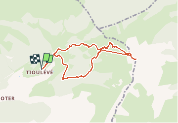
![](/images/other/stat-length.png)
![Randonnée Ski de randonnée Montsapey - Mont Bellacha - Photo](https://media.geolcdn.com/t/1900/400/33136092-656b-499f-b457-d355b1b50b3b.jpg&format=pjpeg&maxdim=2)
Mont Bellacha
nadd73
Utilisateur GUIDE
![Longueur](/images/other/stat-length.png)
![Altitude max](https://static1.geolcdn.com/siteimages/upload/files/1508320355ic_sort_altitude_max_24dp.png)
![Dénivelé positif](https://static1.geolcdn.com/siteimages/upload/files/1508320355ic_sort_den_pos_24dp.png)
![Km-Effort](/images/other/stat-length.png)
![Altitude min](https://static1.geolcdn.com/siteimages/upload/files/1508320355ic_sort_altitude_min_24dp.png)
![Dénivelé négatif](https://static1.geolcdn.com/siteimages/upload/files/1508320355ic_sort_den_neg_24dp.png)
![Boucle](https://static1.geolcdn.com/siteimages/upload/files/16400158638029165_repeat_loop_refresh_sync_direction_icon.png)
![Ski de randonnée](https://static1.geolcdn.com/sitytour/trail-icons/503.png)
4h35
Difficulté : Difficile
![Scannez ce code QR pour ouvrir la randonnée dans l'application SityTrail](https://capi.geolives.com/qq0zvz2zws4bq2lad0pu/sitytour/trails/2692703/qr.png?size=200)
Application GPS de randonnée GRATUITE
À propos
Randonnée Ski de randonnée de 8,9 km à découvrir à Auvergne-Rhône-Alpes, Savoie, Montsapey. Cette randonnée est proposée par nadd73.
Description
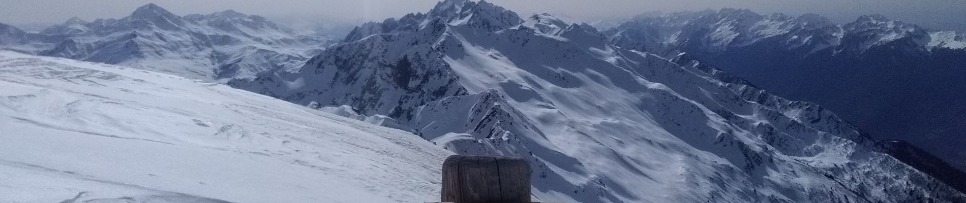
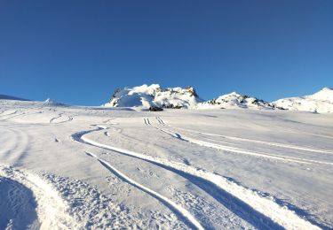
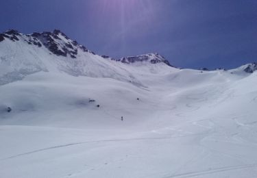
De leuilever, à la montée j'ai pris le chemin d'été de la grande combe. Énormément de coulées à traverser et neige encore dure (9h30).
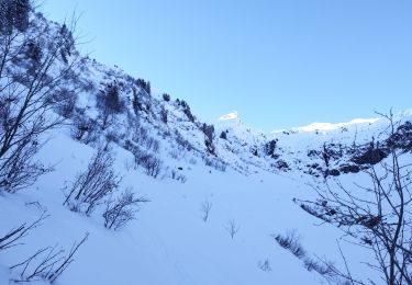
A la grande combe une énorme avalanche qui descend jusqu'en bas.
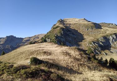
Pas d'avalanche dans la pente de Bellacha 😊.
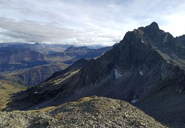
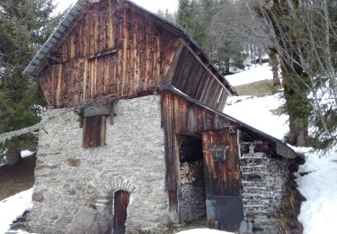
La descente j'ai tiré rive droite pour arriver au dessus du chalet des rouelles.
Localisation
Commentaires
Randonnées à proximité
![Randonnée Marche La Léchère - pte de Glais rouge, des Arangles et Roche brisée - Photo](https://media.geolcdn.com/t/375/260/1baaaa90-37a8-4237-b92e-53be672474e7.jpg&format=jpg&maxdim=2)
![Marche Marche](https://static1.geolcdn.com/sitytour/trail-icons/101.png)
Marche
![](/images/other/stat-length.png)
![](https://static1.geolcdn.com/siteimages/upload/files/16400158638029165_repeat_loop_refresh_sync_direction_icon.png)
![Randonnée Marche Montsapey - Lac Clartan et plus - Photo](https://media.geolcdn.com/t/375/260/a3945484-2742-42e9-b6c0-fb5c4b25df2b.jpg&format=jpg&maxdim=2)
![Marche Marche](https://static1.geolcdn.com/sitytour/trail-icons/101.png)
Marche
![](/images/other/stat-length.png)
![](https://static1.geolcdn.com/siteimages/upload/files/16400158638029165_repeat_loop_refresh_sync_direction_icon.png)
![Randonnée Ski de randonnée La Léchère - tricotage vers Les Teurs. - Photo](https://media.geolcdn.com/t/375/260/00642df7-11bb-44cc-a75b-471b0d819f21.jpg&format=jpg&maxdim=2)
![Ski de randonnée Ski de randonnée](https://static1.geolcdn.com/sitytour/trail-icons/503.png)
Ski de randonnée
![](/images/other/stat-length.png)
![](https://static1.geolcdn.com/siteimages/upload/files/16400158638029165_repeat_loop_refresh_sync_direction_icon.png)
![Randonnée Ski de randonnée La Léchère - Les marmottes noires - Photo](https://media.geolcdn.com/t/375/260/b231a722-c719-4ca9-8520-60ac6ec172da.jpg&format=jpg&maxdim=2)
![Ski de randonnée Ski de randonnée](https://static1.geolcdn.com/sitytour/trail-icons/503.png)
Ski de randonnée
![](/images/other/stat-length.png)
![](https://static1.geolcdn.com/siteimages/upload/files/16400158638029165_repeat_loop_refresh_sync_direction_icon.png)
![Randonnée Marche La Léchère - les marmottes noires et Bellacha - Photo](https://media.geolcdn.com/t/375/260/2e4efe3f-cf03-4e44-8f86-163d48b8b315.jpg&format=jpg&maxdim=2)
![Marche Marche](https://static1.geolcdn.com/sitytour/trail-icons/101.png)
Marche
![](/images/other/stat-length.png)
![](https://static1.geolcdn.com/siteimages/upload/files/16400158638029165_repeat_loop_refresh_sync_direction_icon.png)
![Randonnée Marche La Léchère - lac de Clartan et grande muraille - Photo](https://media.geolcdn.com/t/375/260/4b4bb2ac-ceed-47da-944d-e4142550d609.jpg&format=jpg&maxdim=2)
![Marche Marche](https://static1.geolcdn.com/sitytour/trail-icons/101.png)
Marche
![](/images/other/stat-length.png)
![](https://static1.geolcdn.com/siteimages/upload/files/16400158638029165_repeat_loop_refresh_sync_direction_icon.png)
![Randonnée Ski de randonnée Montsapey - Combe bronsin collu au Nord 2400 - Photo](https://media.geolcdn.com/t/375/260/075f145a-4ea4-41d5-a1b1-7236cce549f1.jpg&format=jpg&maxdim=2)
![Ski de randonnée Ski de randonnée](https://static1.geolcdn.com/sitytour/trail-icons/503.png)
Ski de randonnée
![](/images/other/stat-length.png)
![](https://static1.geolcdn.com/siteimages/upload/files/16400158638029165_repeat_loop_refresh_sync_direction_icon.png)
![Randonnée Ski de randonnée Montsapey - Char de la Turche petit Arc - Photo](https://media.geolcdn.com/t/375/260/c78c2927-8463-4c7f-83f8-ddb38dc03f48.jpg&format=jpg&maxdim=2)
![Ski de randonnée Ski de randonnée](https://static1.geolcdn.com/sitytour/trail-icons/503.png)
Ski de randonnée
![](/images/other/stat-length.png)
![](https://static1.geolcdn.com/siteimages/upload/files/16400158638029165_repeat_loop_refresh_sync_direction_icon.png)
![Randonnée Ski de randonnée Montsapey - pas de Freydon - Photo](https://media.geolcdn.com/t/375/260/878ecc25-aa9c-40b4-b58b-a735c66cffef.jpg&format=jpg&maxdim=2)
![Ski de randonnée Ski de randonnée](https://static1.geolcdn.com/sitytour/trail-icons/503.png)
Ski de randonnée
![](/images/other/stat-length.png)
![](https://static1.geolcdn.com/siteimages/upload/files/16400158638029165_repeat_loop_refresh_sync_direction_icon.png)