![](/images/other/stat-length.png)
![Randonnée Marche Ovillers-la-Boisselle - La Boissellerie - Photo](https://media.geolcdn.com/t/1900/400/9d3a626c-3914-4a11-9643-13abb3fa822f.jpg&format=pjpeg&maxdim=2)
La Boissellerie
jpblimond
Utilisateur
![Longueur](/images/other/stat-length.png)
Longueur
18,4 km
![Altitude max](https://static1.geolcdn.com/siteimages/upload/files/1508320355ic_sort_altitude_max_24dp.png)
Altitude max
130 m
![Dénivelé positif](https://static1.geolcdn.com/siteimages/upload/files/1508320355ic_sort_den_pos_24dp.png)
Dénivelé positif
232 m
![Km-Effort](/images/other/stat-length.png)
Km-Effort
21 km
![Altitude min](https://static1.geolcdn.com/siteimages/upload/files/1508320355ic_sort_altitude_min_24dp.png)
Altitude min
57 m
![Dénivelé négatif](https://static1.geolcdn.com/siteimages/upload/files/1508320355ic_sort_den_neg_24dp.png)
Dénivelé négatif
230 m
![Boucle](https://static1.geolcdn.com/siteimages/upload/files/16400158638029165_repeat_loop_refresh_sync_direction_icon.png)
Boucle
Oui
Date de création :
2021-02-28 11:48:16.0
Dernière modification :
2021-03-06 14:15:25.772
![Marche](https://static1.geolcdn.com/sitytour/trail-icons/101.png)
4h22
Difficulté : Moyen
![Scannez ce code QR pour ouvrir la randonnée dans l'application SityTrail](https://capi.geolives.com/qq0zvz2zws4bq2lad0pu/sitytour/trails/2689507/qr.png?size=200)
Application GPS de randonnée GRATUITE
À propos
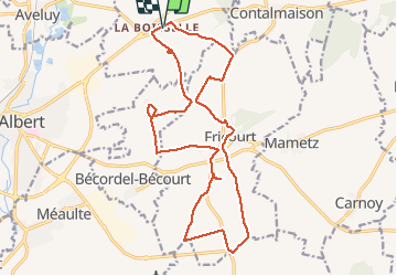
Randonnée Marche de 18,4 km à découvrir à Hauts-de-France, Somme, Ovillers-la-Boisselle. Cette randonnée est proposée par jpblimond.
Description
Attention !
Après Fricourt sur le retour
Le chemin n'existe plus après le bois de Bécordel.
Passage à travers champs pour rejoindre la D147.
Localisation
Pays :
France
Région :
Hauts-de-France
Département/Province :
Somme
Commune :
Ovillers-la-Boisselle
Localité :
Unknown
Départ:(Dec)
Départ:(UTM)
478174 ; 5540970 (31U) N.
Commentaires
Randonnées à proximité
![Randonnée Marche Thiepval - Autour du mémorial de Thiepval - Photo](https://media.geolcdn.com/t/375/260/ext.jpg?maxdim=2&url=https%3A%2F%2Fservices.sitytrail.com%2FGeolivesWS%2FDownloadMedia.ashx%3FTrailID%3D108848%26Media%3D2392_2.jpg)
![Marche Marche](https://static1.geolcdn.com/sitytour/trail-icons/101.png)
Autour du mémorial de Thiepval
Marche
Difficile
(1)
Thiepval,
Hauts-de-France,
Somme,
France
![](/images/other/stat-length.png)
14,1 km | 16,9 km-effort
4h 30min
![](https://static1.geolcdn.com/siteimages/upload/files/16400158638029165_repeat_loop_refresh_sync_direction_icon.png)
Oui
![Randonnée Marche Bazentin - jean Baptiste et le Dragon rouge - Photo](https://media.geolcdn.com/t/375/260/2af02069-3071-4cb3-90d8-dff60db081d6.jpg&format=jpg&maxdim=2)
![Marche Marche](https://static1.geolcdn.com/sitytour/trail-icons/101.png)
jean Baptiste et le Dragon rouge
Marche
Facile
Bazentin,
Hauts-de-France,
Somme,
France
![](/images/other/stat-length.png)
13 km | 15,6 km-effort
2h 9min
![](https://static1.geolcdn.com/siteimages/upload/files/16400158638029165_repeat_loop_refresh_sync_direction_icon.png)
Oui
![Randonnée Marche Thiepval - thiepval - Photo](https://media.geolcdn.com/t/375/260/ext.jpg?maxdim=2&url=https%3A%2F%2Fstatic1.geolcdn.com%2Fsiteimages%2Fupload%2Ffiles%2F1553511878bg_sport_marche.png)
![Marche Marche](https://static1.geolcdn.com/sitytour/trail-icons/101.png)
thiepval
Marche
Difficile
(1)
Thiepval,
Hauts-de-France,
Somme,
France
![](/images/other/stat-length.png)
14,5 km | 17,3 km-effort
2h 7min
![](https://static1.geolcdn.com/siteimages/upload/files/16400158638029165_repeat_loop_refresh_sync_direction_icon.png)
Oui
![Randonnée Vélo Albert - Le Souvenir - Albert à Miraumont - Photo](https://media.geolcdn.com/t/375/260/ext.jpg?maxdim=2&url=https%3A%2F%2Fservices.sitytrail.com%2FGeolivesWS%2FDownloadMedia.ashx%3FTrailID%3D109974%26Media%3D5055_1.jpg)
![Vélo Vélo](https://static1.geolcdn.com/sitytour/trail-icons/200.png)
Le Souvenir - Albert à Miraumont
Vélo
Difficile
Albert,
Hauts-de-France,
Somme,
France
![](/images/other/stat-length.png)
50 km | 57 km-effort
3h 0min
![](https://static1.geolcdn.com/siteimages/upload/files/16400158638029165_repeat_loop_refresh_sync_direction_icon.png)
Oui
![Randonnée Marche Martinpuich - Le sentier de l'Abbaye d'Eaucourt - Photo](https://media.geolcdn.com/t/375/260/ext.jpg?maxdim=2&url=https%3A%2F%2Fservices.sitytrail.com%2FGeolivesWS%2FDownloadMedia.ashx%3FTrailID%3D109746%26Media%3D4572_2.jpg)
![Marche Marche](https://static1.geolcdn.com/sitytour/trail-icons/101.png)
Le sentier de l'Abbaye d'Eaucourt
Marche
Difficile
Martinpuich,
Hauts-de-France,
Pas-de-Calais,
France
![](/images/other/stat-length.png)
16,2 km | 18,2 km-effort
4h 15min
![](https://static1.geolcdn.com/siteimages/upload/files/16400158638029165_repeat_loop_refresh_sync_direction_icon.png)
Oui
![Randonnée Marche Thiepval - Autour du mémorial de Thiepval (variante courte) - Photo](https://media.geolcdn.com/t/375/260/ext.jpg?maxdim=2&url=https%3A%2F%2Fservices.sitytrail.com%2FGeolivesWS%2FDownloadMedia.ashx%3FTrailID%3D108874%26Media%3D2418_1.jpg)
![Marche Marche](https://static1.geolcdn.com/sitytour/trail-icons/101.png)
Autour du mémorial de Thiepval (variante courte)
Marche
Moyen
Thiepval,
Hauts-de-France,
Somme,
France
![](/images/other/stat-length.png)
7,6 km | 9,2 km-effort
2h 30min
![](https://static1.geolcdn.com/siteimages/upload/files/16400158638029165_repeat_loop_refresh_sync_direction_icon.png)
Oui
![Randonnée A pied Thiepval - thiepval 14 KM - Photo](https://media.geolcdn.com/t/375/260/ext.jpg?maxdim=2&url=https%3A%2F%2Fstatic1.geolcdn.com%2Fsiteimages%2Fupload%2Ffiles%2F1545311037marcheuse_200dpi.jpg)
![A pied A pied](https://static1.geolcdn.com/sitytour/trail-icons/100.png)
thiepval 14 KM
A pied
Facile
Thiepval,
Hauts-de-France,
Somme,
France
![](/images/other/stat-length.png)
13,8 km | 16,6 km-effort
3h 46min
![](https://static1.geolcdn.com/siteimages/upload/files/16400158638029165_repeat_loop_refresh_sync_direction_icon.png)
Oui
![Randonnée V.T.C. Albert - Albert Péronne - Photo](https://media.geolcdn.com/t/375/260/ext.jpg?maxdim=2&url=https%3A%2F%2Fstatic1.geolcdn.com%2Fsiteimages%2Fupload%2Ffiles%2F1524743154velo.jpg)
![V.T.C. V.T.C.](https://static1.geolcdn.com/sitytour/trail-icons/203.png)
Albert Péronne
V.T.C.
Très facile
Albert,
Hauts-de-France,
Somme,
France
![](/images/other/stat-length.png)
39 km | 45 km-effort
3h 1min
![](https://static1.geolcdn.com/siteimages/upload/files/16400158638029165_repeat_loop_refresh_sync_direction_icon.png)
Non
![Randonnée V.T.C. Albert - Boucle d Albert - Photo](https://media.geolcdn.com/t/375/260/ext.jpg?maxdim=2&url=https%3A%2F%2Fstatic1.geolcdn.com%2Fsiteimages%2Fupload%2Ffiles%2F1524743154velo.jpg)
![V.T.C. V.T.C.](https://static1.geolcdn.com/sitytour/trail-icons/203.png)
Boucle d Albert
V.T.C.
Très facile
Albert,
Hauts-de-France,
Somme,
France
![](/images/other/stat-length.png)
33 km | 38 km-effort
2h 38min
![](https://static1.geolcdn.com/siteimages/upload/files/16400158638029165_repeat_loop_refresh_sync_direction_icon.png)
Oui