![](/images/other/stat-length.png)
![Randonnée Marche Cassis - Calanques de CASSIS port miou en vau port pin la cacau - Photo](https://media.geolcdn.com/t/1900/400/80522ba5-0e98-45ef-818c-b49e36a4602e.jpg&format=pjpeg&maxdim=2)
Calanques de CASSIS port miou en vau port pin la cacau
TOULAUDIN
Utilisateur
![Longueur](/images/other/stat-length.png)
![Altitude max](https://static1.geolcdn.com/siteimages/upload/files/1508320355ic_sort_altitude_max_24dp.png)
![Dénivelé positif](https://static1.geolcdn.com/siteimages/upload/files/1508320355ic_sort_den_pos_24dp.png)
![Km-Effort](/images/other/stat-length.png)
![Altitude min](https://static1.geolcdn.com/siteimages/upload/files/1508320355ic_sort_altitude_min_24dp.png)
![Dénivelé négatif](https://static1.geolcdn.com/siteimages/upload/files/1508320355ic_sort_den_neg_24dp.png)
![Boucle](https://static1.geolcdn.com/siteimages/upload/files/16400158638029165_repeat_loop_refresh_sync_direction_icon.png)
![Marche](https://static1.geolcdn.com/sitytour/trail-icons/101.png)
5h58
Difficulté : Moyen
![Scannez ce code QR pour ouvrir la randonnée dans l'application SityTrail](https://capi.geolives.com/qq0zvz2zws4bq2lad0pu/sitytour/trails/2688562/qr.png?size=200)
Application GPS de randonnée GRATUITE
À propos
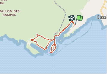
Randonnée Marche de 8,8 km à découvrir à Provence-Alpes-Côte d'Azur, Bouches-du-Rhône, Cassis. Cette randonnée est proposée par TOULAUDIN.
Description
sentier pas difficile mais être vigilant car roche calcaire parfois glissante
on à renoncé à le descente dans la calanque d'en vau par prudence
mais c'est possible il faut juste faire très attention.la pointe de la Cacau vaut
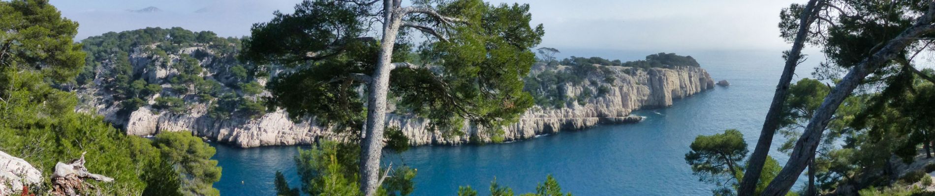
le détour très belle vue sur port miou et les falaises soubeyranes
à noter difficulté de trouver un stationnement à Cassis pas trop loin du départ nous avons stationné av notre dame 1€/H
Localisation
Commentaires
Randonnées à proximité
![Randonnée Vélo de route Cassis - Marseille Cassis Route - Photo](https://media.geolcdn.com/t/375/260/3a21b855-f65e-4548-9ca8-5f083c8a8d79.jpg&format=jpg&maxdim=2)
![Vélo de route Vélo de route](https://static1.geolcdn.com/sitytour/trail-icons/201.png)
Vélo de route
![](/images/other/stat-length.png)
![](https://static1.geolcdn.com/siteimages/upload/files/16400158638029165_repeat_loop_refresh_sync_direction_icon.png)
![Marche Marche](https://static1.geolcdn.com/sitytour/trail-icons/101.png)
Marche
![](/images/other/stat-length.png)
![](https://static1.geolcdn.com/siteimages/upload/files/16400158638029165_repeat_loop_refresh_sync_direction_icon.png)
![Randonnée Marche Cassis - Les 3 Calanques coté Est - Port Miou - En Vau - Port Pin (2eme version) - Photo](https://media.geolcdn.com/t/375/260/6c8be29c-e655-4254-9b79-f66629a31e7b.jpg&format=jpg&maxdim=2)
![Marche Marche](https://static1.geolcdn.com/sitytour/trail-icons/101.png)
Marche
![](/images/other/stat-length.png)
![](https://static1.geolcdn.com/siteimages/upload/files/16400158638029165_repeat_loop_refresh_sync_direction_icon.png)
![Randonnée Marche Cassis - Cassis - La couronne de Charlemagne - Cap canaille - Photo](https://media.geolcdn.com/t/375/260/3dbefdc1-c4a5-41cb-82fb-882826196b25.jpg&format=jpg&maxdim=2)
![Marche Marche](https://static1.geolcdn.com/sitytour/trail-icons/101.png)
Marche
![](/images/other/stat-length.png)
![](https://static1.geolcdn.com/siteimages/upload/files/16400158638029165_repeat_loop_refresh_sync_direction_icon.png)
![Randonnée Marche Cassis - les calanques de Cassis - Photo](https://media.geolcdn.com/t/375/260/ext.jpg?maxdim=2&url=https%3A%2F%2Fservices.sitytrail.com%2FGeolivesWS%2FDownloadMedia.ashx%3FTrailID%3D572132%26Media%3Dfix__20160520153044.jpg)
![Marche Marche](https://static1.geolcdn.com/sitytour/trail-icons/101.png)
Marche
![](/images/other/stat-length.png)
![](https://static1.geolcdn.com/siteimages/upload/files/16400158638029165_repeat_loop_refresh_sync_direction_icon.png)
![Randonnée Marche Cassis - Traversée des Calanques 1/2 - Photo](https://media.geolcdn.com/t/375/260/ext.jpg?maxdim=2&url=https%3A%2F%2Fstatic1.geolcdn.com%2Fsiteimages%2Fupload%2Ffiles%2F1553511878bg_sport_marche.png)
![Marche Marche](https://static1.geolcdn.com/sitytour/trail-icons/101.png)
Marche
![](/images/other/stat-length.png)
![](https://static1.geolcdn.com/siteimages/upload/files/16400158638029165_repeat_loop_refresh_sync_direction_icon.png)
![Randonnée Marche Marseille - Calanques - Aiguille Eissadon - Col Devenson - En vau - Col l'Oule - Photo](https://media.geolcdn.com/t/375/260/ext.jpg?maxdim=2&url=https%3A%2F%2Fstatic1.geolcdn.com%2Fsiteimages%2Fupload%2Ffiles%2F1553511878bg_sport_marche.png)
![Marche Marche](https://static1.geolcdn.com/sitytour/trail-icons/101.png)
Marche
![](/images/other/stat-length.png)
![](https://static1.geolcdn.com/siteimages/upload/files/16400158638029165_repeat_loop_refresh_sync_direction_icon.png)
![Randonnée Marche Cassis - La Pointe Sud d'en Vau, depuis Cassis - Photo](https://media.geolcdn.com/t/375/260/ext.jpg?maxdim=2&url=https%3A%2F%2Fservices.sitytrail.com%2FGeolivesWS%2FDownloadMedia.ashx%3FTrailID%3D191386%26Media%3D14955_1.jpg)
![Marche Marche](https://static1.geolcdn.com/sitytour/trail-icons/101.png)
Marche
![](/images/other/stat-length.png)
![](https://static1.geolcdn.com/siteimages/upload/files/16400158638029165_repeat_loop_refresh_sync_direction_icon.png)
![Randonnée Marche Cassis - Rando Cassis - Mont Gibaou - Photo](https://media.geolcdn.com/t/375/260/ext.jpg?maxdim=2&url=https%3A%2F%2Fservices.sitytrail.com%2FGeolivesWS%2FDownloadMedia.ashx%3FTrailID%3D103791%26Media%3D6561_1.jpg)
![Marche Marche](https://static1.geolcdn.com/sitytour/trail-icons/101.png)
Marche
![](/images/other/stat-length.png)
![](https://static1.geolcdn.com/siteimages/upload/files/16400158638029165_repeat_loop_refresh_sync_direction_icon.png)