![](/images/other/stat-length.png)
![Randonnée V.T.C. Bagnoles-de-l'Orne-Normandie - bagnoles de l'ore - Photo](https://media.geolcdn.com/t/1900/400/4eea9336-edc2-458e-9d5f-3a5eced18dc8.jpg&format=pjpeg&maxdim=2)
bagnoles de l'ore
valetg
Utilisateur
![Longueur](/images/other/stat-length.png)
Longueur
18,6 km
![Altitude max](https://static1.geolcdn.com/siteimages/upload/files/1508320355ic_sort_altitude_max_24dp.png)
Altitude max
225 m
![Dénivelé positif](https://static1.geolcdn.com/siteimages/upload/files/1508320355ic_sort_den_pos_24dp.png)
Dénivelé positif
214 m
![Km-Effort](/images/other/stat-length.png)
Km-Effort
22 km
![Altitude min](https://static1.geolcdn.com/siteimages/upload/files/1508320355ic_sort_altitude_min_24dp.png)
Altitude min
147 m
![Dénivelé négatif](https://static1.geolcdn.com/siteimages/upload/files/1508320355ic_sort_den_neg_24dp.png)
Dénivelé négatif
218 m
![Boucle](https://static1.geolcdn.com/siteimages/upload/files/16400158638029165_repeat_loop_refresh_sync_direction_icon.png)
Boucle
Oui
Date de création :
2021-02-24 11:20:23.624
Dernière modification :
2021-02-24 13:41:32.095
![V.T.C.](https://static1.geolcdn.com/sitytour/trail-icons/203.png)
1h41
Difficulté : Facile
![Scannez ce code QR pour ouvrir la randonnée dans l'application SityTrail](https://capi.geolives.com/qq0zvz2zws4bq2lad0pu/sitytour/trails/2683314/qr.png?size=200)
Application GPS de randonnée GRATUITE
À propos
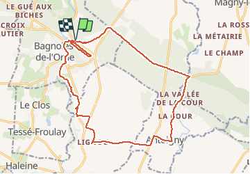
Randonnée V.T.C. de 18,6 km à découvrir à Normandie, Orne, Bagnoles-de-l'Orne-Normandie. Cette randonnée est proposée par valetg.
Description
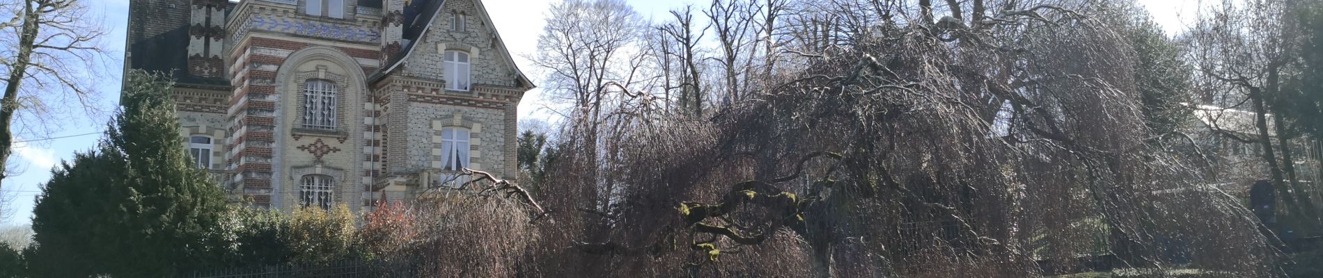
un tour dans la forêt, puis la campagne pour finir au cœur de la ville thermale de bagnoles de l'Orne et ses maisons somptueuses. une curiosité
Localisation
Pays :
France
Région :
Normandie
Département/Province :
Orne
Commune :
Bagnoles-de-l'Orne-Normandie
Localité :
Bagnoles-de-l'Orne
Départ:(Dec)
Départ:(UTM)
690940 ; 5381478 (30U) N.
Commentaires
Randonnées à proximité
![Randonnée A pied Rives-d'Andaine - Sentier des Templiers - Photo](https://media.geolcdn.com/t/375/260/7f8f2913-590f-4c31-b4e9-64954dd46906.jpeg&format=jpg&maxdim=2)
![A pied A pied](https://static1.geolcdn.com/sitytour/trail-icons/100.png)
Sentier des Templiers
A pied
Facile
Rives-d'Andaine,
Normandie,
Orne,
France
![](/images/other/stat-length.png)
4,9 km | 6,2 km-effort
1h 23min
![](https://static1.geolcdn.com/siteimages/upload/files/16400158638029165_repeat_loop_refresh_sync_direction_icon.png)
Non
![Randonnée Marche Bagnoles-de-l'Orne-Normandie - Saint Ortaire - Photo](https://media.geolcdn.com/t/375/260/ext.jpg?maxdim=2&url=https%3A%2F%2Fstatic1.geolcdn.com%2Fsiteimages%2Fupload%2Ffiles%2F1553511878bg_sport_marche.png)
![Marche Marche](https://static1.geolcdn.com/sitytour/trail-icons/101.png)
Saint Ortaire
Marche
Difficile
(1)
Bagnoles-de-l'Orne-Normandie,
Normandie,
Orne,
France
![](/images/other/stat-length.png)
5,5 km | 6,9 km-effort
1h 39min
![](https://static1.geolcdn.com/siteimages/upload/files/16400158638029165_repeat_loop_refresh_sync_direction_icon.png)
Oui
![Randonnée Marche Bagnoles-de-l'Orne-Normandie - Forêt d'Andaine - Photo](https://media.geolcdn.com/t/375/260/4445009f-5e34-4cf0-9270-1184d385e215.jpg&format=jpg&maxdim=2)
![Marche Marche](https://static1.geolcdn.com/sitytour/trail-icons/101.png)
Forêt d'Andaine
Marche
Facile
Bagnoles-de-l'Orne-Normandie,
Normandie,
Orne,
France
![](/images/other/stat-length.png)
3,6 km | 4,2 km-effort
2h 0min
![](https://static1.geolcdn.com/siteimages/upload/files/16400158638029165_repeat_loop_refresh_sync_direction_icon.png)
Non
![Randonnée A pied Bagnoles-de-l'Orne-Normandie - Les Arbres remarquables de Bagnoles-de-l'Orne - Photo](https://media.geolcdn.com/t/375/260/3f5af4f6-b5c2-468d-a381-1ea1dcd7f8d4.jpeg&format=jpg&maxdim=2)
![A pied A pied](https://static1.geolcdn.com/sitytour/trail-icons/100.png)
Les Arbres remarquables de Bagnoles-de-l'Orne
A pied
Facile
Bagnoles-de-l'Orne-Normandie,
Normandie,
Orne,
France
![](/images/other/stat-length.png)
7,7 km | 9 km-effort
2h 2min
![](https://static1.geolcdn.com/siteimages/upload/files/16400158638029165_repeat_loop_refresh_sync_direction_icon.png)
Oui
![Randonnée A pied Bagnoles-de-l'Orne-Normandie - Bagnoles-de-l'Orne - Photo](https://media.geolcdn.com/t/375/260/352c0479-80dd-4a7d-ade5-52d7e1895bb3.jpeg&format=jpg&maxdim=2)
![A pied A pied](https://static1.geolcdn.com/sitytour/trail-icons/100.png)
Bagnoles-de-l'Orne
A pied
Facile
Bagnoles-de-l'Orne-Normandie,
Normandie,
Orne,
France
![](/images/other/stat-length.png)
8,2 km | 9,7 km-effort
2h 11min
![](https://static1.geolcdn.com/siteimages/upload/files/16400158638029165_repeat_loop_refresh_sync_direction_icon.png)
Non
![Randonnée A pied La Ferté-Macé - Circuit des Bornes Cavalières - Photo](https://media.geolcdn.com/t/375/260/ae4572a0-be41-42e4-9cb7-abcf5f5905ac.jpeg&format=jpg&maxdim=2)
![A pied A pied](https://static1.geolcdn.com/sitytour/trail-icons/100.png)
Circuit des Bornes Cavalières
A pied
Facile
La Ferté-Macé,
Normandie,
Orne,
France
![](/images/other/stat-length.png)
8 km | 9,5 km-effort
2h 10min
![](https://static1.geolcdn.com/siteimages/upload/files/16400158638029165_repeat_loop_refresh_sync_direction_icon.png)
Non
![Randonnée Marche Magny-le-Désert - Andaines - Villiers - Photo](https://media.geolcdn.com/t/375/260/ext.jpg?maxdim=2&url=https%3A%2F%2Fstatic1.geolcdn.com%2Fsiteimages%2Fupload%2Ffiles%2F1553511878bg_sport_marche.png)
![Marche Marche](https://static1.geolcdn.com/sitytour/trail-icons/101.png)
Andaines - Villiers
Marche
Moyen
(1)
Magny-le-Désert,
Normandie,
Orne,
France
![](/images/other/stat-length.png)
10,6 km | 13,6 km-effort
2h 36min
![](https://static1.geolcdn.com/siteimages/upload/files/16400158638029165_repeat_loop_refresh_sync_direction_icon.png)
Oui
![Randonnée Marche Bagnoles-de-l'Orne-Normandie - Bagnoles de l' orne - Photo](https://media.geolcdn.com/t/375/260/fa0660f3-37d7-48ea-8a93-ad724fc5fdf8.jpg&format=jpg&maxdim=2)
![Marche Marche](https://static1.geolcdn.com/sitytour/trail-icons/101.png)
Bagnoles de l' orne
Marche
Très facile
Bagnoles-de-l'Orne-Normandie,
Normandie,
Orne,
France
![](/images/other/stat-length.png)
4,8 km | 6,1 km-effort
1h 49min
![](https://static1.geolcdn.com/siteimages/upload/files/16400158638029165_repeat_loop_refresh_sync_direction_icon.png)
Oui
![Randonnée Marche Bagnoles-de-l'Orne-Normandie - bagnole de l orne - Photo](https://media.geolcdn.com/t/375/260/43a8163c-0967-482d-b4a8-4e78d64fb14a.jpg&format=jpg&maxdim=2)
![Marche Marche](https://static1.geolcdn.com/sitytour/trail-icons/101.png)
bagnole de l orne
Marche
Moyen
Bagnoles-de-l'Orne-Normandie,
Normandie,
Orne,
France
![](/images/other/stat-length.png)
8,2 km | 10 km-effort
4h 5min
![](https://static1.geolcdn.com/siteimages/upload/files/16400158638029165_repeat_loop_refresh_sync_direction_icon.png)
Oui