![](/images/other/stat-length.png)
![Randonnée Marche Saint-Raphaël - Belle Barbe - Photo](https://media.geolcdn.com/t/1900/400/ext.pjpeg?maxdim=2&url=https%3A%2F%2Fstatic1.geolcdn.com%2Fsiteimages%2Fupload%2Ffiles%2F1553511878bg_sport_marche.png)
Belle Barbe
jlrayon
Utilisateur
![Longueur](/images/other/stat-length.png)
Longueur
14,6 km
![Altitude max](https://static1.geolcdn.com/siteimages/upload/files/1508320355ic_sort_altitude_max_24dp.png)
Altitude max
219 m
![Dénivelé positif](https://static1.geolcdn.com/siteimages/upload/files/1508320355ic_sort_den_pos_24dp.png)
Dénivelé positif
367 m
![Km-Effort](/images/other/stat-length.png)
Km-Effort
19,5 km
![Altitude min](https://static1.geolcdn.com/siteimages/upload/files/1508320355ic_sort_altitude_min_24dp.png)
Altitude min
25 m
![Dénivelé négatif](https://static1.geolcdn.com/siteimages/upload/files/1508320355ic_sort_den_neg_24dp.png)
Dénivelé négatif
368 m
![Boucle](https://static1.geolcdn.com/siteimages/upload/files/16400158638029165_repeat_loop_refresh_sync_direction_icon.png)
Boucle
Oui
Date de création :
2014-12-10 00:00:00.0
Dernière modification :
2014-12-10 00:00:00.0
![Marche](https://static1.geolcdn.com/sitytour/trail-icons/101.png)
4h55
Difficulté : Moyen
![Scannez ce code QR pour ouvrir la randonnée dans l'application SityTrail](https://capi.geolives.com/qq0zvz2zws4bq2lad0pu/sitytour/trails/268132/qr.png?size=200)
Application GPS de randonnée GRATUITE
À propos
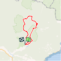
Randonnée Marche de 14,6 km à découvrir à Provence-Alpes-Côte d'Azur, Var, Saint-Raphaël. Cette randonnée est proposée par jlrayon.
Description
Dans l’Estérel du col de Belle Barbe au ravin de Mal Infernet en passant par le col Aubert, le col du Baladou, le col du Perthus, la baisse de la Petite Vache, la baisse de la Grosse Vache, le ravin du Mal Infernet et retour à Belle Barbe.
Localisation
Pays :
France
Région :
Provence-Alpes-Côte d'Azur
Département/Province :
Var
Commune :
Saint-Raphaël
Localité :
Unknown
Départ:(Dec)
Départ:(UTM)
327569 ; 4813709 (32T) N.
Commentaires
Randonnées à proximité
![Randonnée Marche Saint-Raphaël - Sommet du Bonnet de Capelan - Photo](https://media.geolcdn.com/t/375/260/05863c9a-49da-4f41-9bfb-5d37c8a1781d.jpg&format=jpg&maxdim=2)
![Marche Marche](https://static1.geolcdn.com/sitytour/trail-icons/101.png)
Sommet du Bonnet de Capelan
Marche
Très difficile
(1)
Saint-Raphaël,
Provence-Alpes-Côte d'Azur,
Var,
France
![](/images/other/stat-length.png)
17,7 km | 25 km-effort
4h 40min
![](https://static1.geolcdn.com/siteimages/upload/files/16400158638029165_repeat_loop_refresh_sync_direction_icon.png)
Oui
![Randonnée Marche Saint-Raphaël - Massif d'ésterel-grande boucle pic cap roux - Photo](https://media.geolcdn.com/t/375/260/75f5531d-898d-4f51-8086-6652c6aad722.jpg&format=jpg&maxdim=2)
![Marche Marche](https://static1.geolcdn.com/sitytour/trail-icons/101.png)
Massif d'ésterel-grande boucle pic cap roux
Marche
Moyen
(2)
Saint-Raphaël,
Provence-Alpes-Côte d'Azur,
Var,
France
![](/images/other/stat-length.png)
10,4 km | 17,5 km-effort
2h 58min
![](https://static1.geolcdn.com/siteimages/upload/files/16400158638029165_repeat_loop_refresh_sync_direction_icon.png)
Oui
![Randonnée Marche Saint-Raphaël - Les lacs par les rochers du Caneiret - Photo](https://media.geolcdn.com/t/375/260/cddead80-47f3-4091-93b3-1398b473dc08.jpg&format=jpg&maxdim=2)
![Marche Marche](https://static1.geolcdn.com/sitytour/trail-icons/101.png)
Les lacs par les rochers du Caneiret
Marche
Moyen
(1)
Saint-Raphaël,
Provence-Alpes-Côte d'Azur,
Var,
France
![](/images/other/stat-length.png)
20 km | 29 km-effort
5h 7min
![](https://static1.geolcdn.com/siteimages/upload/files/16400158638029165_repeat_loop_refresh_sync_direction_icon.png)
Oui
![Randonnée Marche Saint-Raphaël - le Dramont - Photo](https://media.geolcdn.com/t/375/260/83d1f287-d047-452c-844a-302c6891c476.jpg&format=jpg&maxdim=2)
![Marche Marche](https://static1.geolcdn.com/sitytour/trail-icons/101.png)
le Dramont
Marche
Moyen
(2)
Saint-Raphaël,
Provence-Alpes-Côte d'Azur,
Var,
France
![](/images/other/stat-length.png)
5,7 km | 8,3 km-effort
2h 32min
![](https://static1.geolcdn.com/siteimages/upload/files/16400158638029165_repeat_loop_refresh_sync_direction_icon.png)
Oui
![Randonnée Marche Saint-Raphaël - Le tour du Pic du Cap Roux - St Raphaël (Agay) - Photo](https://media.geolcdn.com/t/375/260/ext.jpg?maxdim=2&url=https%3A%2F%2Fservices.sitytrail.com%2FGeolivesWS%2FDownloadMedia.ashx%3FTrailID%3D317929%26Media%3D17353_6.jpg)
![Marche Marche](https://static1.geolcdn.com/sitytour/trail-icons/101.png)
Le tour du Pic du Cap Roux - St Raphaël (Agay)
Marche
Moyen
(2)
Saint-Raphaël,
Provence-Alpes-Côte d'Azur,
Var,
France
![](/images/other/stat-length.png)
7,2 km | 12,8 km-effort
2h 0min
![](https://static1.geolcdn.com/siteimages/upload/files/16400158638029165_repeat_loop_refresh_sync_direction_icon.png)
Oui
![Randonnée Marche Saint-Raphaël - Pic du Cap Roux - Photo](https://media.geolcdn.com/t/375/260/ext.jpg?maxdim=2&url=https%3A%2F%2Fservices.sitytrail.com%2FGeolivesWS%2FDownloadMedia.ashx%3FTrailID%3D230669%26Media%3Dfix__20131103111411.jpg)
![Marche Marche](https://static1.geolcdn.com/sitytour/trail-icons/101.png)
Pic du Cap Roux
Marche
Très facile
(4)
Saint-Raphaël,
Provence-Alpes-Côte d'Azur,
Var,
France
![](/images/other/stat-length.png)
4,1 km | 7,8 km-effort
1h 17min
![](https://static1.geolcdn.com/siteimages/upload/files/16400158638029165_repeat_loop_refresh_sync_direction_icon.png)
Oui
![Randonnée Marche Saint-Raphaël - Théoule ND - Aiguille - Photo](https://media.geolcdn.com/t/375/260/ext.jpg?maxdim=2&url=https%3A%2F%2Fstatic1.geolcdn.com%2Fsiteimages%2Fupload%2Ffiles%2F1553511878bg_sport_marche.png)
![Marche Marche](https://static1.geolcdn.com/sitytour/trail-icons/101.png)
Théoule ND - Aiguille
Marche
Très difficile
(1)
Saint-Raphaël,
Provence-Alpes-Côte d'Azur,
Var,
France
![](/images/other/stat-length.png)
18,1 km | 29 km-effort
6h 40min
![](https://static1.geolcdn.com/siteimages/upload/files/16400158638029165_repeat_loop_refresh_sync_direction_icon.png)
Oui
![Randonnée Marche Saint-Raphaël - Agay - Sainte-Barbe - Étang des Nénuphares - Photo](https://media.geolcdn.com/t/375/260/dfb7073a-02d4-4811-84ba-99dc2878a0d2.jpg&format=jpg&maxdim=2)
![Marche Marche](https://static1.geolcdn.com/sitytour/trail-icons/101.png)
Agay - Sainte-Barbe - Étang des Nénuphares
Marche
Facile
(2)
Saint-Raphaël,
Provence-Alpes-Côte d'Azur,
Var,
France
![](/images/other/stat-length.png)
5 km | 6,2 km-effort
2h 8min
![](https://static1.geolcdn.com/siteimages/upload/files/16400158638029165_repeat_loop_refresh_sync_direction_icon.png)
Oui
![Randonnée Marche Saint-Raphaël - Tour du Pic de l'Ours - Le Trayas - Photo](https://media.geolcdn.com/t/375/260/ext.jpg?maxdim=2&url=https%3A%2F%2Fservices.sitytrail.com%2FGeolivesWS%2FDownloadMedia.ashx%3FTrailID%3D191486%26Media%3D15078_2.jpg)
![Marche Marche](https://static1.geolcdn.com/sitytour/trail-icons/101.png)
Tour du Pic de l'Ours - Le Trayas
Marche
Moyen
(1)
Saint-Raphaël,
Provence-Alpes-Côte d'Azur,
Var,
France
![](/images/other/stat-length.png)
9,5 km | 16 km-effort
3h 0min
![](https://static1.geolcdn.com/siteimages/upload/files/16400158638029165_repeat_loop_refresh_sync_direction_icon.png)
Oui