![](/images/other/stat-length.png)
![Randonnée Marche Paris - Paris sur Seine - Photo](https://media.geolcdn.com/t/1900/400/f838627b-a430-4093-958b-89492877952c.jpg&format=pjpeg&maxdim=2)
Paris sur Seine
c.chehere
Utilisateur
![Longueur](/images/other/stat-length.png)
Longueur
16,2 km
![Altitude max](https://static1.geolcdn.com/siteimages/upload/files/1508320355ic_sort_altitude_max_24dp.png)
Altitude max
85 m
![Dénivelé positif](https://static1.geolcdn.com/siteimages/upload/files/1508320355ic_sort_den_pos_24dp.png)
Dénivelé positif
268 m
![Km-Effort](/images/other/stat-length.png)
Km-Effort
19,7 km
![Altitude min](https://static1.geolcdn.com/siteimages/upload/files/1508320355ic_sort_altitude_min_24dp.png)
Altitude min
20 m
![Dénivelé négatif](https://static1.geolcdn.com/siteimages/upload/files/1508320355ic_sort_den_neg_24dp.png)
Dénivelé négatif
268 m
![Boucle](https://static1.geolcdn.com/siteimages/upload/files/16400158638029165_repeat_loop_refresh_sync_direction_icon.png)
Boucle
Non
Date de création :
2021-02-22 07:26:09.65
Dernière modification :
2021-02-22 13:58:32.585
![Marche](https://static1.geolcdn.com/sitytour/trail-icons/101.png)
4h47
Difficulté : Facile
![Scannez ce code QR pour ouvrir la randonnée dans l'application SityTrail](https://capi.geolives.com/qq0zvz2zws4bq2lad0pu/sitytour/trails/2680740/qr.png?size=200)
Application GPS de randonnée GRATUITE
À propos
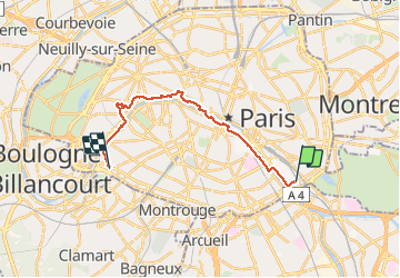
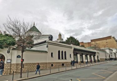
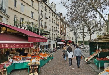
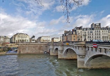
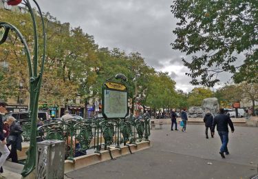
Randonnée Marche de 16,2 km à découvrir à Île-de-France, Paris, Paris. Cette randonnée est proposée par c.chehere.
Description
Balade urbaine en suivant la Seine. Depuis la station "baron Leroy" du T3a jusqu'à la place Balard. Possibilité de reprendre le T3a.
Itinéraire balisé GR 2 & 22.
Localisation
Pays :
France
Région :
Île-de-France
Département/Province :
Paris
Commune :
Paris
Localité :
Paris 12e Arrondissement
Départ:(Dec)
Départ:(UTM)
455485 ; 5408775 (31U) N.
Commentaires
Randonnées à proximité
![Randonnée Marche Paris - Balade Paris Mars - Street art 13 ème / Tours Novel / Mouffetard---> Montorgueil - Photo](https://media.geolcdn.com/t/375/260/f8997d8c-ff6a-4865-a3fa-0c8ffc9300f3.jpg&format=jpg&maxdim=2)
![Marche Marche](https://static1.geolcdn.com/sitytour/trail-icons/101.png)
Balade Paris Mars - Street art 13 ème / Tours Novel / Mouffetard---> Montorgueil
Marche
Très facile
(1)
Paris,
Île-de-France,
Paris,
France
![](/images/other/stat-length.png)
18,4 km | 22 km-effort
6h 21min
![](https://static1.geolcdn.com/siteimages/upload/files/16400158638029165_repeat_loop_refresh_sync_direction_icon.png)
Non
![Randonnée Marche Paris - Balade parisienne le 28 février - Photo](https://media.geolcdn.com/t/375/260/68aea2de-42ab-49c3-94e6-4fbf1fbdd020.jpg&format=jpg&maxdim=2)
![Marche Marche](https://static1.geolcdn.com/sitytour/trail-icons/101.png)
Balade parisienne le 28 février
Marche
Très facile
(1)
Paris,
Île-de-France,
Paris,
France
![](/images/other/stat-length.png)
23 km | 27 km-effort
5h 39min
![](https://static1.geolcdn.com/siteimages/upload/files/16400158638029165_repeat_loop_refresh_sync_direction_icon.png)
Non
![Randonnée Marche Paris - PAH-02 - Photo](https://media.geolcdn.com/t/375/260/ee3b1f27-bb87-433f-86a1-54f44c35876e.jpg&format=jpg&maxdim=2)
![Marche Marche](https://static1.geolcdn.com/sitytour/trail-icons/101.png)
![Randonnée Marche Paris - DP75-16 De Chevaleret à Tolbiac - Photo](https://media.geolcdn.com/t/375/260/8a47c3b6-24b3-49fa-a2b6-5293a39f948c.jpg&format=jpg&maxdim=2)
![Marche Marche](https://static1.geolcdn.com/sitytour/trail-icons/101.png)
DP75-16 De Chevaleret à Tolbiac
Marche
Facile
(1)
Paris,
Île-de-France,
Paris,
France
![](/images/other/stat-length.png)
4,3 km | 5,1 km-effort
1h 8min
![](https://static1.geolcdn.com/siteimages/upload/files/16400158638029165_repeat_loop_refresh_sync_direction_icon.png)
Non
![Randonnée Marche Paris - DP75-15 Du square Saint-Médard à Chevaleret - Photo](https://media.geolcdn.com/t/375/260/78e272bf-5c47-4ff2-b6dd-62e8326c2885.jpg&format=jpg&maxdim=2)
![Marche Marche](https://static1.geolcdn.com/sitytour/trail-icons/101.png)
DP75-15 Du square Saint-Médard à Chevaleret
Marche
Facile
(1)
Paris,
Île-de-France,
Paris,
France
![](/images/other/stat-length.png)
3,3 km | 4 km-effort
54min
![](https://static1.geolcdn.com/siteimages/upload/files/16400158638029165_repeat_loop_refresh_sync_direction_icon.png)
Non
![Randonnée Marche Paris - DP75-14 De Sèvres-Babylone au square Saint-Médard - Photo](https://media.geolcdn.com/t/375/260/a199d31d-b175-4057-acc7-f0c89d3fc917.jpg&format=jpg&maxdim=2)
![Marche Marche](https://static1.geolcdn.com/sitytour/trail-icons/101.png)
DP75-14 De Sèvres-Babylone au square Saint-Médard
Marche
Facile
(1)
Paris,
Île-de-France,
Paris,
France
![](/images/other/stat-length.png)
5 km | 5,8 km-effort
1h 18min
![](https://static1.geolcdn.com/siteimages/upload/files/16400158638029165_repeat_loop_refresh_sync_direction_icon.png)
Non
![Randonnée Marche Paris - DP75-09 De l'Hôtel de Ville à Invalides - Photo](https://media.geolcdn.com/t/375/260/865635ba-b03a-40ab-adac-58ed4742b4c6.jpg&format=jpg&maxdim=2)
![Marche Marche](https://static1.geolcdn.com/sitytour/trail-icons/101.png)
DP75-09 De l'Hôtel de Ville à Invalides
Marche
Facile
(1)
Paris,
Île-de-France,
Paris,
France
![](/images/other/stat-length.png)
4,4 km | 5,3 km-effort
1h 12min
![](https://static1.geolcdn.com/siteimages/upload/files/16400158638029165_repeat_loop_refresh_sync_direction_icon.png)
Non
![Randonnée Marche Paris - DP75-07 De Maraîchers au carrefour Daumesnil - Hecto-Malot - Photo](https://media.geolcdn.com/t/375/260/f01e2afd-b4ca-46d4-a57e-1d08cf143cbf.jpg&format=jpg&maxdim=2)
![Marche Marche](https://static1.geolcdn.com/sitytour/trail-icons/101.png)
DP75-07 De Maraîchers au carrefour Daumesnil - Hecto-Malot
Marche
Facile
(1)
Paris,
Île-de-France,
Paris,
France
![](/images/other/stat-length.png)
4,8 km | 5,4 km-effort
1h 13min
![](https://static1.geolcdn.com/siteimages/upload/files/16400158638029165_repeat_loop_refresh_sync_direction_icon.png)
Non
![Randonnée Marche Paris - DP75-05 De Goncourt à Porte de Bagnolet - Photo](https://media.geolcdn.com/t/375/260/552f8292-8390-4b20-8ba7-076e18f66d66.jpg&format=jpg&maxdim=2)
![Marche Marche](https://static1.geolcdn.com/sitytour/trail-icons/101.png)
DP75-05 De Goncourt à Porte de Bagnolet
Marche
Facile
(1)
Paris,
Île-de-France,
Paris,
France
![](/images/other/stat-length.png)
4,2 km | 5 km-effort
1h 8min
![](https://static1.geolcdn.com/siteimages/upload/files/16400158638029165_repeat_loop_refresh_sync_direction_icon.png)
Non