Randonnée Marche Verviers - fays - Photo
 simoan
simoan

Utilisateur

© OpenStreetMap contributors
Longueur
Longueur
13,7 km
Altitude max
Altitude max
354 m
Dénivelé positif
Dénivelé positif
195 m
Km-Effort
Km-Effort  
16,3 km
Altitude min
Altitude min
235 m
Dénivelé négatif
Dénivelé négatif
195 m
Boucle
Boucle
Oui
Date de création :
2021-02-19 11:12:29.595
Dernière modification :
2021-02-19 11:12:55.646

(0 Avis)

Marche
Marche
3h42
Difficulté : Difficile

Scannez ce code QR pour ouvrir la randonnée dans l'application SityTrail

Application GPS de randonnée GRATUITE

Logo SityTrail SityTrail

IGN / Instituts géographiques

Télécharger SityTrail sur l'App Store Télécharger SityTrail sur Google Play

Logo SityTrail SityTrail World

Le monde est à vous

Télécharger SityTrail sur l'App Store Télécharger SityTrail sur Google Play Télécharger SityTrail sur Huawei AppGallery

À propos

Randonnée Marche de 13,7 km à découvrir à Wallonie, Liège, Verviers. Cette randonnée est proposée par simoan.

Profil altimétrique

Localisation

Pays :
Belgique
Région :
Wallonie
Département/Province :
Liège
Commune :
Verviers
Localité :
Heusy
Départ:(UTM)
704427 ; 5607229 (31U) N.

Randonnées à proximité

Randonnée Marche Limbourg - RB-Lg-28_Limbourg - Photo
Marche
PRO

Marche

(5)
Limbourg, Wallonie, Liège, Belgique
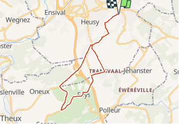
19,9 km | 26 km-effort
5h 49min
Oui
Randonnée Marche Verviers - Grand vivier - Cossart - Photo
Marche
simoan

Marche

Facile
(5)
Verviers, Wallonie, Liège, Belgique
4,7 km | 6,4 km-effort
1h 26min
Oui
Randonnée Marche Theux - 20220901 - Jehanster 5.3 Km - Photo
Marche
GUIDE
pierreh01

Marche

Moyen
(1)
Theux, Wallonie, Liège, Belgique
5,3 km | 6,8 km-effort
1h 32min
Oui
Randonnée Marche Limbourg - RL-GG-11_Dolhain-Gileppe_Pepinster - Photo
Marche
PRO

Marche

Très difficile
(2)
Limbourg, Wallonie, Liège, Belgique
20 km | 26 km-effort
5h 33min
Non
Randonnée Marche Limbourg - 20200606 - Hèvremont 8 Km - Photo
Marche
GUIDE
pierreh01

Marche

Difficile
(1)
Limbourg, Wallonie, Liège, Belgique
7,9 km | 10,7 km-effort
1h 34min
Oui
Randonnée A pied Theux - Chemin des Sources - Initiation à la randonnée dans la région de Polleur - Photo
A pied
PRO

A pied

Facile
(1)
Theux, Wallonie, Liège, Belgique
7,5 km | 9,9 km-effort
2h 14min
Oui
Randonnée Marche Verviers - Stembert . les Roudoudous . Stembert - Photo
Marche
GUIDE
stef789

Marche

Facile
(2)
Verviers, Wallonie, Liège, Belgique
10,5 km | 13,5 km-effort
2h 48min
Oui
Randonnée Marche Theux - jehanster . croix du petit Jean . vervifontaine . foyr . surister . jehanster  - Photo
Marche
GUIDE
stef789

Marche

Facile
(2)
Theux, Wallonie, Liège, Belgique
9,9 km | 11,9 km-effort
2h 31min
Oui
Randonnée Marche Theux - Chemin des Sources |étape n°7 JEHANSTER  – THEUX - Photo
Marche
PRO

Marche

Très difficile
(2)
Theux, Wallonie, Liège, Belgique
15,2 km | 19,2 km-effort
4h 21min
Non


Fermer
Mes abonnements