![](/images/other/stat-length.png)
![Randonnée Marche Péruwelz - 10 km Roucourt - Photo](https://media.geolcdn.com/t/1900/400/ext.pjpeg?maxdim=2&url=https%3A%2F%2Fstatic1.geolcdn.com%2Fsiteimages%2Fupload%2Ffiles%2F1553511878bg_sport_marche.png)
10 km Roucourt
doclocjl
Utilisateur
![Longueur](/images/other/stat-length.png)
Longueur
10,4 km
![Altitude max](https://static1.geolcdn.com/siteimages/upload/files/1508320355ic_sort_altitude_max_24dp.png)
Altitude max
47 m
![Dénivelé positif](https://static1.geolcdn.com/siteimages/upload/files/1508320355ic_sort_den_pos_24dp.png)
Dénivelé positif
63 m
![Km-Effort](/images/other/stat-length.png)
Km-Effort
11,3 km
![Altitude min](https://static1.geolcdn.com/siteimages/upload/files/1508320355ic_sort_altitude_min_24dp.png)
Altitude min
28 m
![Dénivelé négatif](https://static1.geolcdn.com/siteimages/upload/files/1508320355ic_sort_den_neg_24dp.png)
Dénivelé négatif
75 m
![Boucle](https://static1.geolcdn.com/siteimages/upload/files/16400158638029165_repeat_loop_refresh_sync_direction_icon.png)
Boucle
Non
Date de création :
2021-02-16 13:00:48.0
Dernière modification :
2021-02-17 08:02:40.57
![Marche](https://static1.geolcdn.com/sitytour/trail-icons/101.png)
3h34
Difficulté : Facile
![Scannez ce code QR pour ouvrir la randonnée dans l'application SityTrail](https://capi.geolives.com/qq0zvz2zws4bq2lad0pu/sitytour/trails/2673109/qr.png?size=200)
Application GPS de randonnée GRATUITE
À propos
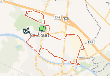
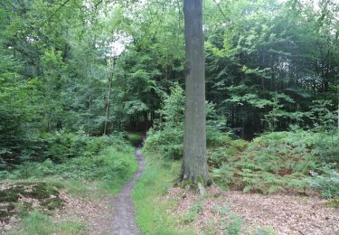
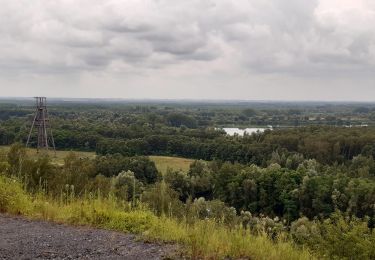
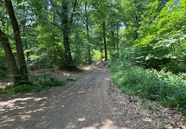
Randonnée Marche de 10,4 km à découvrir à Wallonie, Hainaut, Péruwelz. Cette randonnée est proposée par doclocjl.
Description
parcours inattendu empruntant des chemins que je ne connaissais pas bien que fréquentant régulièrement Bury et environs. Portion dans zoning commercial un peu ennuyeuse mais...
Localisation
Pays :
Belgique
Région :
Wallonie
Département/Province :
Hainaut
Commune :
Péruwelz
Localité :
Roucourt
Départ:(Dec)
Départ:(UTM)
541562 ; 5597617 (31U) N.
Commentaires
Randonnées à proximité
![Randonnée Marche Bernissart - Bon-Secours - Circuit Natura 2000, des sites qui valent le détour - Ht07 - Photo](https://media.geolcdn.com/t/375/260/ext.jpg?maxdim=2&url=https%3A%2F%2Fservices.sitytrail.com%2FGeolivesWS%2FDownloadMedia.ashx%3FTrailID%3D451783%26Media%3D0e2cd755-8e66-4a9b-9a8f-f1f08c8ab555.jpg)
![Marche Marche](https://static1.geolcdn.com/sitytour/trail-icons/101.png)
Bon-Secours - Circuit Natura 2000, des sites qui valent le détour - Ht07
Marche
Facile
(3)
Bernissart,
Wallonie,
Hainaut,
Belgique
![](/images/other/stat-length.png)
6 km | 7,1 km-effort
1h 37min
![](https://static1.geolcdn.com/siteimages/upload/files/16400158638029165_repeat_loop_refresh_sync_direction_icon.png)
Oui
![Randonnée Marche Péruwelz - Bon Secours à Condé sur Escaut - Photo](https://media.geolcdn.com/t/375/260/ext.jpg?maxdim=2&url=https%3A%2F%2Fservices.sitytrail.com%2FGeolivesWS%2FDownloadMedia.ashx%3FTrailID%3D1057846%26Media%3Dfix__20181010103956.jpg)
![Marche Marche](https://static1.geolcdn.com/sitytour/trail-icons/101.png)
Bon Secours à Condé sur Escaut
Marche
Moyen
(1)
Péruwelz,
Wallonie,
Hainaut,
Belgique
![](/images/other/stat-length.png)
25 km | 27 km-effort
4h 11min
![](https://static1.geolcdn.com/siteimages/upload/files/16400158638029165_repeat_loop_refresh_sync_direction_icon.png)
Oui
![Randonnée Marche Péruwelz - bois Bonsecours - Photo](https://media.geolcdn.com/t/375/260/ext.jpg?maxdim=2&url=https%3A%2F%2Fservices.sitytrail.com%2FGeolivesWS%2FDownloadMedia.ashx%3FTrailID%3D736604%26Media%3D20170420165139.jpg)
![Marche Marche](https://static1.geolcdn.com/sitytour/trail-icons/101.png)
bois Bonsecours
Marche
Facile
(1)
Péruwelz,
Wallonie,
Hainaut,
Belgique
![](/images/other/stat-length.png)
7,8 km | 8,9 km-effort
2h 17min
![](https://static1.geolcdn.com/siteimages/upload/files/16400158638029165_repeat_loop_refresh_sync_direction_icon.png)
Oui
![Randonnée Cheval Péruwelz - Boucle transfrontalière de Bon-Secours - Photo](https://media.geolcdn.com/t/375/260/ext.jpg?maxdim=2&url=https%3A%2F%2Fpivotmedia.tourismewallonie.be%2FANX-02-000EID%2FANX-02-000EID.jpg)
![Cheval Cheval](https://static1.geolcdn.com/sitytour/trail-icons/300.png)
Boucle transfrontalière de Bon-Secours
Cheval
Très facile
Péruwelz,
Wallonie,
Hainaut,
Belgique
![](/images/other/stat-length.png)
11,6 km | 13,2 km-effort
Inconnu
![](https://static1.geolcdn.com/siteimages/upload/files/16400158638029165_repeat_loop_refresh_sync_direction_icon.png)
Oui
![Randonnée V.T.T. Péruwelz - Circuit transfrontalier de la Vergne - Photo](https://media.geolcdn.com/t/375/260/ext.jpg?maxdim=2&url=https%3A%2F%2Fpivotmedia.tourismewallonie.be%2FANX-02-000EXG%2FANX-02-000EXG.jpg)
![V.T.T. V.T.T.](https://static1.geolcdn.com/sitytour/trail-icons/202.png)
Circuit transfrontalier de la Vergne
V.T.T.
Facile
Péruwelz,
Wallonie,
Hainaut,
Belgique
![](/images/other/stat-length.png)
18,8 km | 19,9 km-effort
1h 22min
![](https://static1.geolcdn.com/siteimages/upload/files/16400158638029165_repeat_loop_refresh_sync_direction_icon.png)
Oui
![Randonnée A pied Péruwelz - Circuit du Maréchal de Croÿ - Photo](https://media.geolcdn.com/t/375/260/ext.jpg?maxdim=2&url=https%3A%2F%2Fpivotmedia.tourismewallonie.be%2FANX-02-03VN-00BI%2FANX-02-03VN-00BI.JPG)
![A pied A pied](https://static1.geolcdn.com/sitytour/trail-icons/100.png)
Circuit du Maréchal de Croÿ
A pied
Facile
(1)
Péruwelz,
Wallonie,
Hainaut,
Belgique
![](/images/other/stat-length.png)
4,2 km | 5 km-effort
1h 8min
![](https://static1.geolcdn.com/siteimages/upload/files/16400158638029165_repeat_loop_refresh_sync_direction_icon.png)
Oui
![Randonnée A pied Péruwelz - Circuit de l'Avenue de l'Hermitage - Photo](https://media.geolcdn.com/t/375/260/ext.jpg?maxdim=2&url=https%3A%2F%2Fpivotmedia.tourismewallonie.be%2FANX-02-04OO-003D%2FANX-02-04OO-003D.jpg)
![A pied A pied](https://static1.geolcdn.com/sitytour/trail-icons/100.png)
Circuit de l'Avenue de l'Hermitage
A pied
Facile
(1)
Péruwelz,
Wallonie,
Hainaut,
Belgique
![](/images/other/stat-length.png)
3,1 km | 3,6 km-effort
49min
![](https://static1.geolcdn.com/siteimages/upload/files/16400158638029165_repeat_loop_refresh_sync_direction_icon.png)
Oui
![Randonnée Marche Péruwelz - Forêt de Bon-Secours et pays minier de l’Escaut - Photo](https://media.geolcdn.com/t/375/260/3680e99b-ce40-4268-bcae-a04ab4e0eb36.jpg&format=jpg&maxdim=2)
![Marche Marche](https://static1.geolcdn.com/sitytour/trail-icons/101.png)
Forêt de Bon-Secours et pays minier de l’Escaut
Marche
Moyen
Péruwelz,
Wallonie,
Hainaut,
Belgique
![](/images/other/stat-length.png)
24 km | 27 km-effort
5h 0min
![](https://static1.geolcdn.com/siteimages/upload/files/16400158638029165_repeat_loop_refresh_sync_direction_icon.png)
Oui
![Randonnée Marche Péruwelz - Bonsecours 16 km - Photo](https://media.geolcdn.com/t/375/260/6138c171-0f41-413e-8f50-e3f8c6c8a8e5.jpg&format=jpg&maxdim=2)
![Marche Marche](https://static1.geolcdn.com/sitytour/trail-icons/101.png)
Bonsecours 16 km
Marche
Facile
Péruwelz,
Wallonie,
Hainaut,
Belgique
![](/images/other/stat-length.png)
15,8 km | 17,7 km-effort
4h 20min
![](https://static1.geolcdn.com/siteimages/upload/files/16400158638029165_repeat_loop_refresh_sync_direction_icon.png)
Oui