Randonnée Marche Ban-sur-Meurthe-Clefcy - SERICHAMPS - Photo
 surceneux
surceneux

Utilisateur

© OpenStreetMap contributors
Longueur
Longueur
4,5 km
Altitude max
Altitude max
1110 m
Dénivelé positif
Dénivelé positif
148 m
Km-Effort
Km-Effort  
6,9 km
Altitude min
Altitude min
841 m
Dénivelé négatif
Dénivelé négatif
273 m
Boucle
Boucle
Non
Date de création :
2021-02-12 14:08:13.682
Dernière modification :
2021-02-12 17:03:14.683

(0 Avis)

Marche
Marche
1h12
Difficulté : Facile

Scannez ce code QR pour ouvrir la randonnée dans l'application SityTrail

Application GPS de randonnée GRATUITE

Logo SityTrail SityTrail

IGN / Instituts géographiques

Télécharger SityTrail sur l'App Store Télécharger SityTrail sur Google Play

Logo SityTrail SityTrail World

Le monde est à vous

Télécharger SityTrail sur l'App Store Télécharger SityTrail sur Google Play Télécharger SityTrail sur Huawei AppGallery

À propos

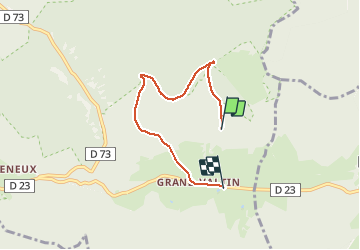
Randonnée Marche de 4,5 km à découvrir à Grand Est, Vosges, Ban-sur-Meurthe-Clefcy. Cette randonnée est proposée par surceneux.

Description

Grd Valtin-Chemin de Sérichamps -Chaume-Chemin du Grand Boroge-Grd Valtin (plus 1 km non enregistré)

Profil altimétrique

Localisation

Pays :
France
Région :
Grand Est
Département/Province :
Vosges
Commune :
Ban-sur-Meurthe-Clefcy
Localité :
Unknown
Départ:(UTM)
350748 ; 5329601 (32U) N.

Randonnées à proximité

Randonnée Marche Le Valtin - Les Rochers des Hirschsteine - Lac Vert - Photo
Marche
GUIDE
Michel1963

Marche

Difficile
(2)
Le Valtin, Grand Est, Vosges, France
14,4 km | 22 km-effort
5h 2min
Oui
Randonnée Marche Le Valtin - Le Sentier des Roches - Photo
Marche
GUIDE
Michel1963

Marche

Difficile
(2)
Le Valtin, Grand Est, Vosges, France
20 km | 34 km-effort
7h 43min
Oui
Randonnée Marche Stosswihr - Tour du belvedere avec le passage sur les crêtes  - Photo
Marche
ocepee

Marche

Très facile
(2)
Stosswihr, Grand Est, Haut-Rhin, France
8,5 km | 0 m-effort
2h 28min
Oui
Randonnée Autre activité Soultzeren - Totom 4 lacs - Photo
Autre activité
dinozore

Autre activité

Moyen
(1)
Soultzeren, Grand Est, Haut-Rhin, France
15,6 km | 26 km-effort
4h 37min
Oui
Randonnée Marche Le Valtin - Les Hirschsteine - Photo
Marche
VacheKiri67

Marche

Difficile
(1)
Le Valtin, Grand Est, Vosges, France
16,1 km | 25 km-effort
6h 28min
Oui
Randonnée Marche Ban-sur-Meurthe-Clefcy - La vallée de Belbriette - Ban-sur-Meurthe-Clefcy - Photo
Marche
tracegps

Marche

Moyen
(2)
Ban-sur-Meurthe-Clefcy, Grand Est, Vosges, France
9,8 km | 12,6 km-effort
2h 30min
Oui
Randonnée Marche Soultzeren - Tanet-Gazon du faing par lac vert et retour sommet du Tanet - Photo
Marche
ride-in-Elsass

Marche

Moyen
(1)
Soultzeren, Grand Est, Haut-Rhin, France
10 km | 15,6 km-effort
4h 24min
Oui
Randonnée Marche Xonrupt-Longemer - 23-08-17 Lac Longemer - Lispach - Photo
Marche
annefrance70

Marche

Moyen
(1)
Xonrupt-Longemer, Grand Est, Vosges, France
7 km | 12,1 km-effort
2h 13min
Oui
Randonnée Marche Xonrupt-Longemer - Le Hohneck et le sentier des roches - Du lac de Longemer au lac de Schiessrothried - Photo
Marche
tracegps

Marche

Difficile
(1)
Xonrupt-Longemer, Grand Est, Vosges, France
15,7 km | 28 km-effort
7h 0min
Non


Fermer
Mes abonnements