![](/images/other/stat-length.png)
![Randonnée Marche Virton - Golf Découverte Virton - Marche_7kms - Photo](https://media.geolcdn.com/t/1900/400/2e94438f-421c-41ca-ba08-c0b43da04d28.jpg&format=pjpeg&maxdim=2)
Golf Découverte Virton - Marche_7kms
Pascal L
Utilisateur
![Longueur](/images/other/stat-length.png)
![Altitude max](https://static1.geolcdn.com/siteimages/upload/files/1508320355ic_sort_altitude_max_24dp.png)
![Dénivelé positif](https://static1.geolcdn.com/siteimages/upload/files/1508320355ic_sort_den_pos_24dp.png)
![Km-Effort](/images/other/stat-length.png)
![Altitude min](https://static1.geolcdn.com/siteimages/upload/files/1508320355ic_sort_altitude_min_24dp.png)
![Dénivelé négatif](https://static1.geolcdn.com/siteimages/upload/files/1508320355ic_sort_den_neg_24dp.png)
![Boucle](https://static1.geolcdn.com/siteimages/upload/files/16400158638029165_repeat_loop_refresh_sync_direction_icon.png)
![Marche](https://static1.geolcdn.com/sitytour/trail-icons/101.png)
1h20
Difficulté : Facile
![Scannez ce code QR pour ouvrir la randonnée dans l'application SityTrail](https://capi.geolives.com/qq0zvz2zws4bq2lad0pu/sitytour/trails/2666708/qr.png?size=200)
Application GPS de randonnée GRATUITE
À propos
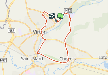
Randonnée Marche de 7,3 km à découvrir à Wallonie, Luxembourg, Virton. Cette randonnée est proposée par Pascal L.
Description
Départ/Retour: Virton (Delhaize)
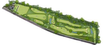
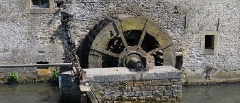
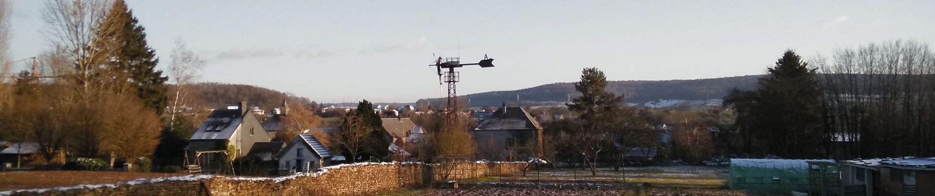
Endroits de passage : Pierrard (Institut des Arts et Métiers), Chenois, Golf Découverte Virton (GDV), Saint-Mard, Vieux-Virton, Ravel (ligne 155), Solumont, Ruisseau le Ton, Virton (centre), Haut de la Vigne.
Ref.
- http://www.golfvirton.be/
- https://www.topsante.com/medecine/votre-sante-vous/sante-pratique/bienfaits-marche-sur-la-sante-637787
- https://virtonjadis.be/
- https://www.sonuma.be/archive/ce-pays-est-a-vous-du-14041970 (La Gaume)
Pour la santé, il est bon de pratiquer entre 30 et 40 minutes d’activité physique par jour. La marche a des nombreux effets bénéfiques sur nos organismes. Nous sommes programmés pour marcher !
(2021.02.10)
Localisation
Commentaires
Randonnées à proximité
![Randonnée Marche Virton - RB-Lu-17_Ethe_via-var-1-et-2-et-3 - Photo](https://media.geolcdn.com/t/375/260/ext.jpg?maxdim=2&url=https%3A%2F%2Fservices.sitytrail.com%2FGeolivesWS%2FDownloadMedia.ashx%3FTrailID%3D541328%26Media%3Df1aeb673-5eb3-40d2-9e3e-9751bd16961f.jpg)
![Marche Marche](https://static1.geolcdn.com/sitytour/trail-icons/101.png)
Marche
![](/images/other/stat-length.png)
![](https://static1.geolcdn.com/siteimages/upload/files/16400158638029165_repeat_loop_refresh_sync_direction_icon.png)
![Randonnée V.T.T. Virton - Autour de Ethe - Balade_VTT_20kms - Photo](https://media.geolcdn.com/t/375/260/7f02a860-4654-49bb-aa49-fc1e5df64440.jpg&format=jpg&maxdim=2)
![V.T.T. V.T.T.](https://static1.geolcdn.com/sitytour/trail-icons/202.png)
V.T.T.
![](/images/other/stat-length.png)
![](https://static1.geolcdn.com/siteimages/upload/files/16400158638029165_repeat_loop_refresh_sync_direction_icon.png)
![Randonnée Marche Virton - GAUME Balade naturelle et historique - Photo](https://media.geolcdn.com/t/375/260/ext.jpg?maxdim=2&url=https%3A%2F%2Fservices.sitytrail.com%2FGeolivesWS%2FDownloadMedia.ashx%3FTrailID%3D164521%26Media%3D20121125163840.jpeg)
![Marche Marche](https://static1.geolcdn.com/sitytour/trail-icons/101.png)
Marche
![](/images/other/stat-length.png)
![](https://static1.geolcdn.com/siteimages/upload/files/16400158638029165_repeat_loop_refresh_sync_direction_icon.png)
![Randonnée A pied Virton - La Bajocienne - Photo](https://media.geolcdn.com/t/375/260/ext.jpg?maxdim=2&url=https%3A%2F%2Fpivotmedia.tourismewallonie.be%2FOTH-A0-006F-3DH1%2FOTH-A0-006F-3DH1.jpg)
![A pied A pied](https://static1.geolcdn.com/sitytour/trail-icons/100.png)
A pied
![](/images/other/stat-length.png)
![](https://static1.geolcdn.com/siteimages/upload/files/16400158638029165_repeat_loop_refresh_sync_direction_icon.png)
![Randonnée Marche Virton - RB-Lu-17_Ethe_via-racc - Photo](https://media.geolcdn.com/t/375/260/ext.jpg?maxdim=2&url=https%3A%2F%2Fservices.sitytrail.com%2FGeolivesWS%2FDownloadMedia.ashx%3FTrailID%3D541324%26Media%3Df9f14959-9764-4ab9-b216-8ff20ce6d698.jpg)
![Marche Marche](https://static1.geolcdn.com/sitytour/trail-icons/101.png)
Marche
![](/images/other/stat-length.png)
![](https://static1.geolcdn.com/siteimages/upload/files/16400158638029165_repeat_loop_refresh_sync_direction_icon.png)
![Randonnée Marche Virton - RB-Lu-17_Ethe - Photo](https://media.geolcdn.com/t/375/260/ext.jpg?maxdim=2&url=https%3A%2F%2Fservices.sitytrail.com%2FGeolivesWS%2FDownloadMedia.ashx%3FTrailID%3D541324%26Media%3D8965deff-6975-4e3c-a1d0-87e46c5ff193.jpg)
![Marche Marche](https://static1.geolcdn.com/sitytour/trail-icons/101.png)
Marche
![](/images/other/stat-length.png)
![](https://static1.geolcdn.com/siteimages/upload/files/16400158638029165_repeat_loop_refresh_sync_direction_icon.png)
![Randonnée Cheval Rouvroy - rallye 2014 - Photo](https://media.geolcdn.com/t/375/260/ext.jpg?maxdim=2&url=https%3A%2F%2Fstatic1.geolcdn.com%2Fsiteimages%2Fupload%2Ffiles%2F1524743154cheval.jpg)
![Cheval Cheval](https://static1.geolcdn.com/sitytour/trail-icons/300.png)
Cheval
![](/images/other/stat-length.png)
![](https://static1.geolcdn.com/siteimages/upload/files/16400158638029165_repeat_loop_refresh_sync_direction_icon.png)
![Randonnée V.T.T. Virton - Autour de Tintigny - Balade_VTT_54Kms - Photo](https://media.geolcdn.com/t/375/260/f2991960-98bf-4ded-84b3-f3460299ceba.jpg&format=jpg&maxdim=2)
![V.T.T. V.T.T.](https://static1.geolcdn.com/sitytour/trail-icons/202.png)
V.T.T.
![](/images/other/stat-length.png)
![](https://static1.geolcdn.com/siteimages/upload/files/16400158638029165_repeat_loop_refresh_sync_direction_icon.png)
![Randonnée V.T.T. Virton - Monquintin - Balade_VTT_22Kms - Photo](https://media.geolcdn.com/t/375/260/136209b8-b776-4094-a6b1-d92770fe7c94.jpg&format=jpg&maxdim=2)
![V.T.T. V.T.T.](https://static1.geolcdn.com/sitytour/trail-icons/202.png)
V.T.T.
![](/images/other/stat-length.png)
![](https://static1.geolcdn.com/siteimages/upload/files/16400158638029165_repeat_loop_refresh_sync_direction_icon.png)