Randonnée Marche Baerenthal - Baerenthal - Photo
 gilbraun67150
gilbraun67150

Utilisateur

© OpenStreetMap contributors
Longueur
Longueur
12 km
Altitude max
Altitude max
351 m
Dénivelé positif
Dénivelé positif
368 m
Km-Effort
Km-Effort  
16,9 km
Altitude min
Altitude min
206 m
Dénivelé négatif
Dénivelé négatif
367 m
Boucle
Boucle
Oui
Date de création :
2014-12-10 00:00:00.0
Dernière modification :
2014-12-10 00:00:00.0

(1 Avis)

Marche
Marche
3h40
Difficulté : Facile

Scannez ce code QR pour ouvrir la randonnée dans l'application SityTrail

Application GPS de randonnée GRATUITE

Logo SityTrail SityTrail

IGN / Instituts géographiques

Télécharger SityTrail sur l'App Store Télécharger SityTrail sur Google Play

Logo SityTrail SityTrail World

Le monde est à vous

Télécharger SityTrail sur l'App Store Télécharger SityTrail sur Google Play Télécharger SityTrail sur Huawei AppGallery

À propos

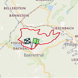
Randonnée Marche de 12 km à découvrir à Grand Est, Moselle, Baerenthal. Cette randonnée est proposée par gilbraun67150.

Description

Départ Ramstein plage,Fischerhof,Col du pt Dunkeithal, col du grd Dunkeithal,  château de Ramstein

Profil altimétrique

Localisation

Pays :
France
Région :
Grand Est
Département/Province :
Moselle
Commune :
Baerenthal
Localité :
Unknown
Départ:(Dec)
Départ:(UTM)
391428 ; 5426368 (32U) N.

Commentaires

Veuillez vous connecter pour laisser un commentaire ou une note


Randonnées à proximité

Randonnée Marche Philippsbourg - Les 3 châteaux : Falkenstein, Rothenbourg, Waldeck - Photo
Marche
tracegps

Marche

Difficile
(1)
Philippsbourg, Grand Est, Moselle, France
16,1 km | 22 km-effort
4h 25min
Oui
Randonnée A pied Reipertswiller - Disque jaune - Photo
A pied
PRO

A pied

Facile
Reipertswiller, Grand Est, Bas-Rhin, France
8,5 km | 11,2 km-effort
2h 32min
Non
Randonnée A pied Philippsbourg - Chevalet jaune - Photo
A pied
PRO

A pied

Facile
Philippsbourg, Grand Est, Moselle, France
7,5 km | 11 km-effort
2h 29min
Non
Randonnée A pied Philippsbourg - Disque rouge - Photo
A pied
PRO

A pied

Facile
Philippsbourg, Grand Est, Moselle, France
6 km | 9,3 km-effort
2h 7min
Non
Randonnée A pied Philippsbourg - Triangle rouge - Photo
A pied
PRO

A pied

Facile
Philippsbourg, Grand Est, Moselle, France
5,1 km | 7,3 km-effort
1h 39min
Non
Randonnée A pied Baerenthal - Anneau jaune - Photo
A pied
PRO

A pied

Facile
Baerenthal, Grand Est, Moselle, France
12,3 km | 15,3 km-effort
3h 28min
Oui
Randonnée A pied Philippsbourg - Sentier Goldenberg - Photo
A pied
PRO

A pied

Facile
Philippsbourg, Grand Est, Moselle, France
5,3 km | 7,1 km-effort
1h 36min
Non
Randonnée A pied Philippsbourg - Croix jaune - Photo
A pied
PRO

A pied

Facile
Philippsbourg, Grand Est, Moselle, France
12,6 km | 19,4 km-effort
4h 24min
Non
Randonnée A pied Philippsbourg - Triangle jaune - Photo
A pied
PRO

A pied

Facile
Philippsbourg, Grand Est, Moselle, France
11,8 km | 15,5 km-effort
3h 30min
Non


Fermer
Mes abonnements