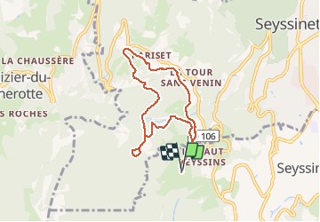
![](/images/other/stat-length.png)
![Randonnée Marche nordique Seyssins - Voie du Tram en circuit jusqu'au Ravaud - Photo](https://media.geolcdn.com/t/1900/400/fa0ca43a-8c40-4351-b20c-d9623a9798c2.jpg&format=pjpeg&maxdim=2)
Voie du Tram en circuit jusqu'au Ravaud
Emelle
Utilisateur
![Longueur](/images/other/stat-length.png)
![Altitude max](https://static1.geolcdn.com/siteimages/upload/files/1508320355ic_sort_altitude_max_24dp.png)
![Dénivelé positif](https://static1.geolcdn.com/siteimages/upload/files/1508320355ic_sort_den_pos_24dp.png)
![Km-Effort](/images/other/stat-length.png)
![Altitude min](https://static1.geolcdn.com/siteimages/upload/files/1508320355ic_sort_altitude_min_24dp.png)
![Dénivelé négatif](https://static1.geolcdn.com/siteimages/upload/files/1508320355ic_sort_den_neg_24dp.png)
![Boucle](https://static1.geolcdn.com/siteimages/upload/files/16400158638029165_repeat_loop_refresh_sync_direction_icon.png)
![Marche nordique](https://static1.geolcdn.com/sitytour/trail-icons/102.png)
2h51
Difficulté : Facile
![Scannez ce code QR pour ouvrir la randonnée dans l'application SityTrail](https://capi.geolives.com/qq0zvz2zws4bq2lad0pu/sitytour/trails/2659184/qr.png?size=200)
Application GPS de randonnée GRATUITE
À propos
Randonnée Marche nordique de 7,4 km à découvrir à Auvergne-Rhône-Alpes, Isère, Seyssins. Cette randonnée est proposée par Emelle.
Description
Belle montée très progressive qui se prête bien à la marche nordique.
Descente plus raide mais agréable en sous-bois.
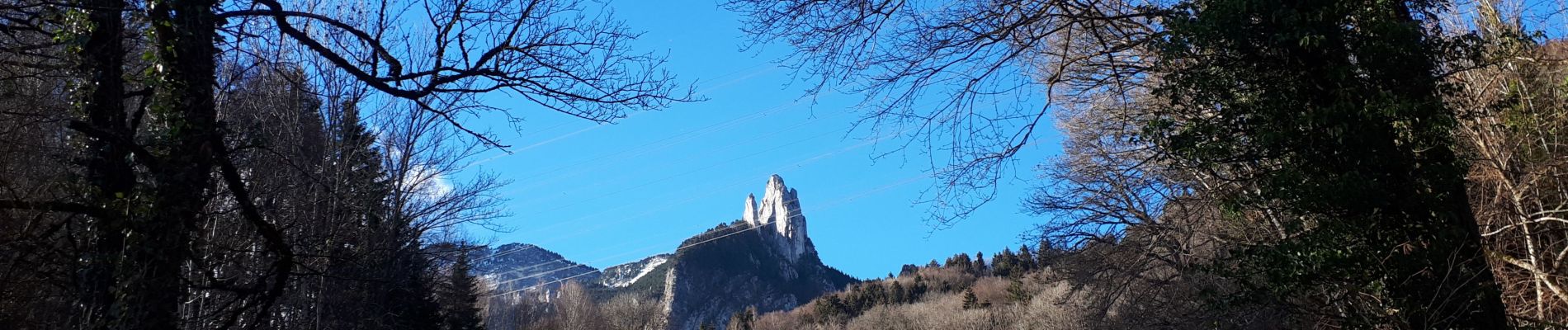
De beaux points de vue sur les 3 Pucelles, la vallée, la Chartreuse, Belledonne, le Taillefer...
Variante : on peut monter rajouter une boucle si on le souhaite jusqu'à la source captée et faire ainsi un 8 complet, retour par le même chemin que celui de cette trace.
Localisation
Commentaires
Randonnées à proximité
![Randonnée Marche nordique Seyssins - Seyssins le haut - Les Arcelles dans la neige - Photo](https://media.geolcdn.com/t/375/260/09832c62-e152-4e15-aea9-389ff5328b66.jpg&format=jpg&maxdim=2)
![Marche nordique Marche nordique](https://static1.geolcdn.com/sitytour/trail-icons/102.png)
Marche nordique
![](/images/other/stat-length.png)
![](https://static1.geolcdn.com/siteimages/upload/files/16400158638029165_repeat_loop_refresh_sync_direction_icon.png)
![Randonnée Marche Engins - Circuit pas de la Lose, du Tracollet, de l'Ours avec un retour par le passage de la Grande Combe - Photo](https://media.geolcdn.com/t/375/260/e578919b-c81c-4fe4-99cc-8260409f6f79.jpg&format=jpg&maxdim=2)
![Marche Marche](https://static1.geolcdn.com/sitytour/trail-icons/101.png)
Marche
![](/images/other/stat-length.png)
![](https://static1.geolcdn.com/siteimages/upload/files/16400158638029165_repeat_loop_refresh_sync_direction_icon.png)
![Randonnée Marche Seyssins - MOUCHEROTTE - Photo](https://media.geolcdn.com/t/375/260/fbc259ea-06fa-4a05-83ef-656dc650e275.jpg&format=jpg&maxdim=2)
![Marche Marche](https://static1.geolcdn.com/sitytour/trail-icons/101.png)
Marche
![](/images/other/stat-length.png)
![](https://static1.geolcdn.com/siteimages/upload/files/16400158638029165_repeat_loop_refresh_sync_direction_icon.png)
![Randonnée Raquettes à neige Lans-en-Vercors - La Crête des Ramées de nuit en raquettes (2018) - Photo](https://media.geolcdn.com/t/375/260/ext.jpg?maxdim=2&url=https%3A%2F%2Fservices.sitytrail.com%2FGeolivesWS%2FDownloadMedia.ashx%3FTrailID%3D897155%26Media%3Dfix__20180130203527.jpg)
![Raquettes à neige Raquettes à neige](https://static1.geolcdn.com/sitytour/trail-icons/504.png)
Raquettes à neige
![](/images/other/stat-length.png)
![](https://static1.geolcdn.com/siteimages/upload/files/16400158638029165_repeat_loop_refresh_sync_direction_icon.png)
![Randonnée Marche Lans-en-Vercors - le vertige des cimes - Photo](https://media.geolcdn.com/t/375/260/2d2e8455-1754-4db8-b9ed-75845d14fe6a.jpg&format=jpg&maxdim=2)
![Marche Marche](https://static1.geolcdn.com/sitytour/trail-icons/101.png)
Marche
![](/images/other/stat-length.png)
![](https://static1.geolcdn.com/siteimages/upload/files/16400158638029165_repeat_loop_refresh_sync_direction_icon.png)
![Randonnée V.T.T. Seyssins - Petite escapade électrique au-dessus de 38 Seyssins - Photo](https://media.geolcdn.com/t/375/260/68bfc982-e63d-4725-88db-1e4968c2728b.jpg&format=jpg&maxdim=2)
![V.T.T. V.T.T.](https://static1.geolcdn.com/sitytour/trail-icons/202.png)
V.T.T.
![](/images/other/stat-length.png)
![](https://static1.geolcdn.com/siteimages/upload/files/16400158638029165_repeat_loop_refresh_sync_direction_icon.png)
![Randonnée Marche Fontaine - M le 20 cabane de Laura - Photo](https://media.geolcdn.com/t/375/260/40be2dc6-e0ec-4dac-a44e-b55a1a5b0b08.jpg&format=jpg&maxdim=2)
![Marche Marche](https://static1.geolcdn.com/sitytour/trail-icons/101.png)
Marche
![](/images/other/stat-length.png)
![](https://static1.geolcdn.com/siteimages/upload/files/16400158638029165_repeat_loop_refresh_sync_direction_icon.png)
![Randonnée Marche Lans-en-Vercors - Lans - Belvédère Vertige des Cimes depuis Le Furon - Photo](https://media.geolcdn.com/t/375/260/ext.jpg?maxdim=2&url=https%3A%2F%2Fservices.sitytrail.com%2FGeolivesWS%2FDownloadMedia.ashx%3FTrailID%3D661434%26Media%3Dfix__20161117114034.jpg)
![Marche Marche](https://static1.geolcdn.com/sitytour/trail-icons/101.png)
Marche
![](/images/other/stat-length.png)
![](https://static1.geolcdn.com/siteimages/upload/files/16400158638029165_repeat_loop_refresh_sync_direction_icon.png)
![Randonnée Course à pied Seyssinet-Pariset - 19 mai - Photo](https://media.geolcdn.com/t/375/260/ext.jpg?maxdim=2&url=https%3A%2F%2Fservices.sitytrail.com%2FGeolivesWS%2FDownloadMedia.ashx%3FTrailID%3D128561%26Media%3D20120519101643.jpg)
![Course à pied Course à pied](https://static1.geolcdn.com/sitytour/trail-icons/103.png)
Course à pied
![](/images/other/stat-length.png)
![](https://static1.geolcdn.com/siteimages/upload/files/16400158638029165_repeat_loop_refresh_sync_direction_icon.png)