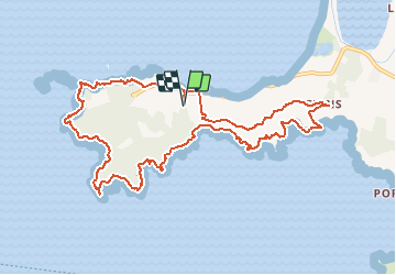
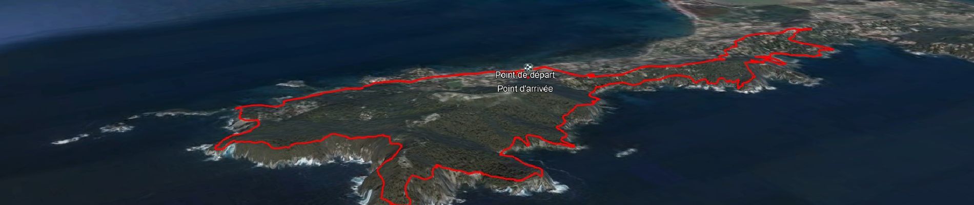
![](/images/other/stat-length.png)
![Randonnée Marche Hyères - Giens Ouest + port du Niel et village de Giens - Photo](https://media.geolcdn.com/t/1900/400/bd7bab5a-2900-4f1f-a633-f134e0b35fdd.jpg&format=pjpeg&maxdim=2)
Giens Ouest + port du Niel et village de Giens
affinetataille
Utilisateur GUIDE
![Longueur](/images/other/stat-length.png)
![Altitude max](https://static1.geolcdn.com/siteimages/upload/files/1508320355ic_sort_altitude_max_24dp.png)
![Dénivelé positif](https://static1.geolcdn.com/siteimages/upload/files/1508320355ic_sort_den_pos_24dp.png)
![Km-Effort](/images/other/stat-length.png)
![Altitude min](https://static1.geolcdn.com/siteimages/upload/files/1508320355ic_sort_altitude_min_24dp.png)
![Dénivelé négatif](https://static1.geolcdn.com/siteimages/upload/files/1508320355ic_sort_den_neg_24dp.png)
![Boucle](https://static1.geolcdn.com/siteimages/upload/files/16400158638029165_repeat_loop_refresh_sync_direction_icon.png)
![Marche](https://static1.geolcdn.com/sitytour/trail-icons/101.png)
5h00
Difficulté : Moyen
![Scannez ce code QR pour ouvrir la randonnée dans l'application SityTrail](https://capi.geolives.com/qq0zvz2zws4bq2lad0pu/sitytour/trails/2653813/qr.png?size=200)
Application GPS de randonnée GRATUITE
À propos
Randonnée Marche de 12,4 km à découvrir à Provence-Alpes-Côte d'Azur, Var, Hyères. Cette randonnée est proposée par affinetataille.
Description
Pkg la Madrague ch.de la table ronde (vers les Darboussières).
faire le tour de la presqu'île de giens, en suivant le bord de mer, en le faisant dans le sens inverse des aiguilles d'une montre.
Arrivés à la plage des darboussières, continuer et monter au sommet de la pointe du Niel (100m). Faire un passage par le port du Niel et le village de Giens.
Revenir par le chemin de crête, puis redescendre en direction du littoral coté madrague, avant de rejoindre le pkg .
Nota: en cas de fatigue, raccourcir en revenant directement depuis la plage des Darboussières.
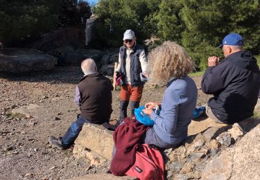
Localisation
Commentaires
Randonnées à proximité
![Randonnée Marche Hyères - Presqu'ile de Giens coté Est (version longue) - Photo](https://media.geolcdn.com/t/375/260/111e178c-db2d-4519-839d-89c97a7ddc38.jpg&format=jpg&maxdim=2)
![Marche Marche](https://static1.geolcdn.com/sitytour/trail-icons/101.png)
Marche
![](/images/other/stat-length.png)
![](https://static1.geolcdn.com/siteimages/upload/files/16400158638029165_repeat_loop_refresh_sync_direction_icon.png)
![Randonnée Marche Hyères - Presqu'ile de Gien_jeannot_22/04/2022 - Photo](https://media.geolcdn.com/t/375/260/8b67de46-9ea6-477a-b826-6ab82c4946f1.jpg&format=jpg&maxdim=2)
![Marche Marche](https://static1.geolcdn.com/sitytour/trail-icons/101.png)
Marche
![](/images/other/stat-length.png)
![](https://static1.geolcdn.com/siteimages/upload/files/16400158638029165_repeat_loop_refresh_sync_direction_icon.png)
![Randonnée Marche Hyères - Tour Fondue - La Madrague - Photo](https://media.geolcdn.com/t/375/260/ext.jpg?maxdim=2&url=https%3A%2F%2Fservices.sitytrail.com%2FGeolivesWS%2FDownloadMedia.ashx%3FTrailID%3D408792%26Media%3Dfix__20150414183437.jpg)
![Marche Marche](https://static1.geolcdn.com/sitytour/trail-icons/101.png)
Marche
![](/images/other/stat-length.png)
![](https://static1.geolcdn.com/siteimages/upload/files/16400158638029165_repeat_loop_refresh_sync_direction_icon.png)
![Randonnée Marche Hyères - pointe ouest - Photo](https://media.geolcdn.com/t/375/260/ext.jpg?maxdim=2&url=https%3A%2F%2Fservices.sitytrail.com%2FGeolivesWS%2FDownloadMedia.ashx%3FTrailID%3D408941%26Media%3Dfix__20150417131644.jpg)
![Marche Marche](https://static1.geolcdn.com/sitytour/trail-icons/101.png)
Marche
![](/images/other/stat-length.png)
![](https://static1.geolcdn.com/siteimages/upload/files/16400158638029165_repeat_loop_refresh_sync_direction_icon.png)
![Randonnée Marche Hyères - giens - Photo](https://media.geolcdn.com/t/375/260/ext.jpg?maxdim=2&url=https%3A%2F%2Fservices.sitytrail.com%2FGeolivesWS%2FDownloadMedia.ashx%3FTrailID%3D215644%26Media%3Dfix__20130821153200.jpg)
![Marche Marche](https://static1.geolcdn.com/sitytour/trail-icons/101.png)
Marche
![](/images/other/stat-length.png)
![](https://static1.geolcdn.com/siteimages/upload/files/16400158638029165_repeat_loop_refresh_sync_direction_icon.png)
![Randonnée Marche Hyères - Presqu'île de Grenoble Est 2/10/21 - Photo](https://media.geolcdn.com/t/375/260/ext.jpg?maxdim=2&url=https%3A%2F%2Fstatic1.geolcdn.com%2Fsiteimages%2Fupload%2Ffiles%2F1553511878bg_sport_marche.png)
![Marche Marche](https://static1.geolcdn.com/sitytour/trail-icons/101.png)
Marche
![](/images/other/stat-length.png)
![](https://static1.geolcdn.com/siteimages/upload/files/16400158638029165_repeat_loop_refresh_sync_direction_icon.png)
![Randonnée Marche Hyères - Tour de la presqu'île de Giens est - Cap Esterel - Photo](https://media.geolcdn.com/t/375/260/cc04081d-d0da-465a-bbda-9226021fb9fc.jpg&format=jpg&maxdim=2)
![Marche Marche](https://static1.geolcdn.com/sitytour/trail-icons/101.png)
Marche
![](/images/other/stat-length.png)
![](https://static1.geolcdn.com/siteimages/upload/files/16400158638029165_repeat_loop_refresh_sync_direction_icon.png)
![Randonnée Marche Hyères - Giens ouest - Photo](https://media.geolcdn.com/t/375/260/df6c7a86-f8e1-4b34-8d72-3a86802b7e0d.jpg&format=jpg&maxdim=2)
![Marche Marche](https://static1.geolcdn.com/sitytour/trail-icons/101.png)
Marche
![](/images/other/stat-length.png)
![](https://static1.geolcdn.com/siteimages/upload/files/16400158638029165_repeat_loop_refresh_sync_direction_icon.png)