![](/images/other/stat-length.png)
![Randonnée Raquettes à neige Gréolières - Gréolières les Neiges - Vallon de la Faye - Combe d'Henry - Foret du Cheiron - Photo](https://media.geolcdn.com/t/1900/400/ext.pjpeg?maxdim=2&url=https%3A%2F%2Fstatic1.geolcdn.com%2Fsiteimages%2Fupload%2Ffiles%2F1524743153raquette.jpg)
Gréolières les Neiges - Vallon de la Faye - Combe d'Henry - Foret du Cheiron
clarambre
Utilisateur
![Longueur](/images/other/stat-length.png)
![Altitude max](https://static1.geolcdn.com/siteimages/upload/files/1508320355ic_sort_altitude_max_24dp.png)
![Dénivelé positif](https://static1.geolcdn.com/siteimages/upload/files/1508320355ic_sort_den_pos_24dp.png)
![Km-Effort](/images/other/stat-length.png)
![Altitude min](https://static1.geolcdn.com/siteimages/upload/files/1508320355ic_sort_altitude_min_24dp.png)
![Dénivelé négatif](https://static1.geolcdn.com/siteimages/upload/files/1508320355ic_sort_den_neg_24dp.png)
![Boucle](https://static1.geolcdn.com/siteimages/upload/files/16400158638029165_repeat_loop_refresh_sync_direction_icon.png)
![Raquettes à neige](https://static1.geolcdn.com/sitytour/trail-icons/504.png)
5h00
Difficulté : Moyen
![Scannez ce code QR pour ouvrir la randonnée dans l'application SityTrail](https://capi.geolives.com/qq0zvz2zws4bq2lad0pu/sitytour/trails/2651251/qr.png?size=200)
Application GPS de randonnée GRATUITE
À propos
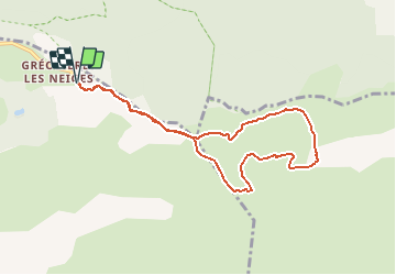
Randonnée Raquettes à neige de 8,7 km à découvrir à Provence-Alpes-Côte d'Azur, Alpes-Maritimes, Gréolières. Cette randonnée est proposée par clarambre.
Description
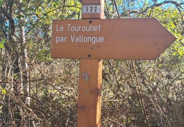
Nous partirons du grand parking de la station (au niveau du restaurant le Chalet du Parc) pour une notre rando/raquette de 8,7 km avec environ 330 m de dénivelé .
Nous prendrons des chemins parmi les arbres et en longeant les pistes de la station, puis nous arriverons dans le vallon de la Faye, nous resterons au pied du Col de Jérusalem et au pied de la croix du verse.
Pause repas à la bergerie de la Combe d'Henry puis retour en longeant la foret du Cheiron .
Départ à 10 h - Arrivée à 15 h (avec les diverses pauses pique nique)
Parcours sans difficulté
Localisation
Commentaires
Randonnées à proximité
![Randonnée A pied Aiglun - Traversée de l'Estéron - Etape 3 - Photo](https://media.geolcdn.com/t/375/260/02747462-a559-4c53-baf5-cbd6ec427027.jpeg&format=jpg&maxdim=2)
![A pied A pied](https://static1.geolcdn.com/sitytour/trail-icons/100.png)
A pied
![](/images/other/stat-length.png)
![](https://static1.geolcdn.com/siteimages/upload/files/16400158638029165_repeat_loop_refresh_sync_direction_icon.png)
![Randonnée A pied Sigale - Circuit de la Cacia - Photo](https://media.geolcdn.com/t/375/260/af8f583b-85f0-4a9c-891f-ad74e419fc87.jpeg&format=jpg&maxdim=2)
![A pied A pied](https://static1.geolcdn.com/sitytour/trail-icons/100.png)
A pied
![](/images/other/stat-length.png)
![](https://static1.geolcdn.com/siteimages/upload/files/16400158638029165_repeat_loop_refresh_sync_direction_icon.png)
![Randonnée A pied Gréolières - Cime du Cheiron - Photo](https://media.geolcdn.com/t/375/260/273aae50-c65a-44a2-8836-25bdf1d17610.jpeg&format=jpg&maxdim=2)
![A pied A pied](https://static1.geolcdn.com/sitytour/trail-icons/100.png)
A pied
![](/images/other/stat-length.png)
![](https://static1.geolcdn.com/siteimages/upload/files/16400158638029165_repeat_loop_refresh_sync_direction_icon.png)
![Randonnée A pied Gréolières - Circuit du Loup - Photo](https://media.geolcdn.com/t/375/260/09dfa2b7-7900-471b-b9af-79ed74d6292b.jpeg&format=jpg&maxdim=2)
![A pied A pied](https://static1.geolcdn.com/sitytour/trail-icons/100.png)
A pied
![](/images/other/stat-length.png)
![](https://static1.geolcdn.com/siteimages/upload/files/16400158638029165_repeat_loop_refresh_sync_direction_icon.png)
![Randonnée A pied Gréolières - Traversée des Miroirs - Photo](https://media.geolcdn.com/t/375/260/273aae50-c65a-44a2-8836-25bdf1d17610.jpeg&format=jpg&maxdim=2)
![A pied A pied](https://static1.geolcdn.com/sitytour/trail-icons/100.png)
A pied
![](/images/other/stat-length.png)
![](https://static1.geolcdn.com/siteimages/upload/files/16400158638029165_repeat_loop_refresh_sync_direction_icon.png)
![Randonnée Marche Sigale - Cime CACCIA, SIGALE (06) - Photo](https://media.geolcdn.com/t/375/260/ext.jpg?maxdim=2&url=https%3A%2F%2Fservices.sitytrail.com%2FGeolivesWS%2FDownloadMedia.ashx%3FTrailID%3D497165%26Media%3Dfix__20151125111722.jpg)
![Marche Marche](https://static1.geolcdn.com/sitytour/trail-icons/101.png)
Marche
![](/images/other/stat-length.png)
![](https://static1.geolcdn.com/siteimages/upload/files/16400158638029165_repeat_loop_refresh_sync_direction_icon.png)
![Randonnée Marche Gréolières - Cretes du Cheiron - Photo](https://media.geolcdn.com/t/375/260/88c8f012-b9cc-414c-b278-7a06867d8cc1.jpg&format=jpg&maxdim=2)
![Marche Marche](https://static1.geolcdn.com/sitytour/trail-icons/101.png)
Marche
![](/images/other/stat-length.png)
![](https://static1.geolcdn.com/siteimages/upload/files/16400158638029165_repeat_loop_refresh_sync_direction_icon.png)
![Randonnée Marche Gréolières - Greolieres au Cheiron - Photo](https://media.geolcdn.com/t/375/260/a795c4bb-6c25-4de9-8cde-b16d0eac6c34.jpg&format=jpg&maxdim=2)
![Marche Marche](https://static1.geolcdn.com/sitytour/trail-icons/101.png)
Marche
![](/images/other/stat-length.png)
![](https://static1.geolcdn.com/siteimages/upload/files/16400158638029165_repeat_loop_refresh_sync_direction_icon.png)
![Randonnée Marche Coursegoules - Circuit de Vallon - Photo](https://media.geolcdn.com/t/375/260/e911973d-e9e7-4d6f-ba50-120e69338c29.jpg&format=jpg&maxdim=2)
![Marche Marche](https://static1.geolcdn.com/sitytour/trail-icons/101.png)
Marche
![](/images/other/stat-length.png)
![](https://static1.geolcdn.com/siteimages/upload/files/16400158638029165_repeat_loop_refresh_sync_direction_icon.png)