![](/images/other/stat-length.png)
![Randonnée Marche Bouclans - Bouclans - Photo](https://media.geolcdn.com/t/1900/400/b38b1ef6-7b8d-4e86-b122-282d5b75dca7.jpg&format=pjpeg&maxdim=2)
Bouclans
eltonnermou
Utilisateur
![Longueur](/images/other/stat-length.png)
![Altitude max](https://static1.geolcdn.com/siteimages/upload/files/1508320355ic_sort_altitude_max_24dp.png)
![Dénivelé positif](https://static1.geolcdn.com/siteimages/upload/files/1508320355ic_sort_den_pos_24dp.png)
![Km-Effort](/images/other/stat-length.png)
![Altitude min](https://static1.geolcdn.com/siteimages/upload/files/1508320355ic_sort_altitude_min_24dp.png)
![Dénivelé négatif](https://static1.geolcdn.com/siteimages/upload/files/1508320355ic_sort_den_neg_24dp.png)
![Boucle](https://static1.geolcdn.com/siteimages/upload/files/16400158638029165_repeat_loop_refresh_sync_direction_icon.png)
![Marche](https://static1.geolcdn.com/sitytour/trail-icons/101.png)
2h32
Difficulté : Moyen
![Scannez ce code QR pour ouvrir la randonnée dans l'application SityTrail](https://capi.geolives.com/qq0zvz2zws4bq2lad0pu/sitytour/trails/2647542/qr.png?size=200)
Application GPS de randonnée GRATUITE
À propos
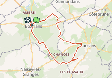
Randonnée Marche de 16,4 km à découvrir à Bourgogne-Franche-Comté, Doubs, Bouclans. Cette randonnée est proposée par eltonnermou.
Description
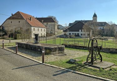
parking espace culturel (en face maxi-marché) ;
rando 3/4 pieds propres
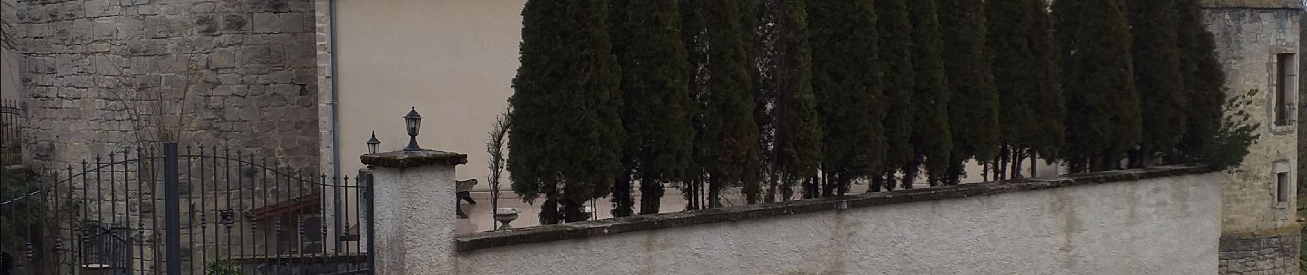
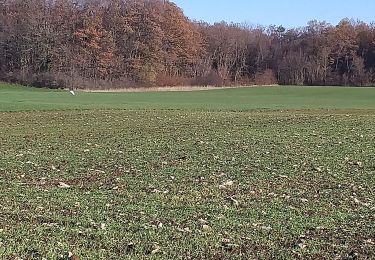
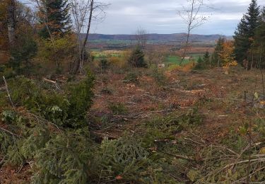
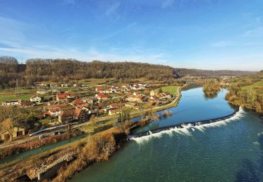
randonnée agréable sur le 1er plateau, à travers prairies et forêts qui à cette saison nous fait profiter de ses éclats de couleur. Un beau défilé entre roches, fort sympathique. Une arrivée face au château de Bouclans pour terminer en beauté
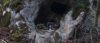
Laissez vous surprendre par le passage d’un ou plusieurs (pour moi ça été 4) chevreuils.
Localisation
Commentaires
Randonnées à proximité
![Randonnée A pied Nancray - Circuit du Chêne Président - Photo](https://media.geolcdn.com/t/375/260/dc9e89f0-7636-4693-8413-5b50fbfab35e.jpeg&format=jpg&maxdim=2)
![A pied A pied](https://static1.geolcdn.com/sitytour/trail-icons/100.png)
A pied
![](/images/other/stat-length.png)
![](https://static1.geolcdn.com/siteimages/upload/files/16400158638029165_repeat_loop_refresh_sync_direction_icon.png)
![Randonnée A pied Nancray - Sentier du Fonteny - Photo](https://media.geolcdn.com/t/375/260/fd4c251e-f96c-43e9-888d-c44f200ccc2c.jpeg&format=jpg&maxdim=2)
![A pied A pied](https://static1.geolcdn.com/sitytour/trail-icons/100.png)
A pied
![](/images/other/stat-length.png)
![](https://static1.geolcdn.com/siteimages/upload/files/16400158638029165_repeat_loop_refresh_sync_direction_icon.png)
![Randonnée A pied Nancray - Sentier du Moulin - Photo](https://media.geolcdn.com/t/375/260/fd4c251e-f96c-43e9-888d-c44f200ccc2c.jpeg&format=jpg&maxdim=2)
![A pied A pied](https://static1.geolcdn.com/sitytour/trail-icons/100.png)
A pied
![](/images/other/stat-length.png)
![](https://static1.geolcdn.com/siteimages/upload/files/16400158638029165_repeat_loop_refresh_sync_direction_icon.png)
![Randonnée Marche Nancray - Nancray-danse - Photo](https://media.geolcdn.com/t/375/260/8f480ddf-1fd3-4568-9b1d-9c27b999fa3d.jpg&format=jpg&maxdim=2)
![Marche Marche](https://static1.geolcdn.com/sitytour/trail-icons/101.png)
Marche
![](/images/other/stat-length.png)
![](https://static1.geolcdn.com/siteimages/upload/files/16400158638029165_repeat_loop_refresh_sync_direction_icon.png)
![Randonnée Marche Naisey-les-Granges - Naisey les Grande - Photo](https://media.geolcdn.com/t/375/260/20e70f5b-f761-4060-a739-20ed2d6736dc.jpg&format=jpg&maxdim=2)
![Marche Marche](https://static1.geolcdn.com/sitytour/trail-icons/101.png)
Marche
![](/images/other/stat-length.png)
![](https://static1.geolcdn.com/siteimages/upload/files/16400158638029165_repeat_loop_refresh_sync_direction_icon.png)
![Randonnée A pied Champlive - Sentier des Crêtes - Photo](https://media.geolcdn.com/t/375/260/7c732505-4f0b-4f56-a014-1317e06c73a8.jpeg&format=jpg&maxdim=2)
![A pied A pied](https://static1.geolcdn.com/sitytour/trail-icons/100.png)
A pied
![](/images/other/stat-length.png)
![](https://static1.geolcdn.com/siteimages/upload/files/16400158638029165_repeat_loop_refresh_sync_direction_icon.png)
![Randonnée Marche Nancray - Nancray moulin - Photo](https://media.geolcdn.com/t/375/260/8957ca98-610e-4c7e-8842-df399f24b994.jpg&format=jpg&maxdim=2)
![Marche Marche](https://static1.geolcdn.com/sitytour/trail-icons/101.png)
Marche
![](/images/other/stat-length.png)
![](https://static1.geolcdn.com/siteimages/upload/files/16400158638029165_repeat_loop_refresh_sync_direction_icon.png)
![Randonnée V.T.T. Nancray - Téléthon 2023 - Photo](https://media.geolcdn.com/t/375/260/8ddc302b-e86c-460e-b5ea-35bc000549b5.png&format=jpg&maxdim=2)
![V.T.T. V.T.T.](https://static1.geolcdn.com/sitytour/trail-icons/202.png)
V.T.T.
![](/images/other/stat-length.png)
![](https://static1.geolcdn.com/siteimages/upload/files/16400158638029165_repeat_loop_refresh_sync_direction_icon.png)
![Randonnée V.T.T. Nancray - Parcours VTT - Téléthon 2022 - Photo](https://media.geolcdn.com/t/375/260/7dafd106-1830-4226-a31b-5e8203b0371b.png&format=jpg&maxdim=2)
![V.T.T. V.T.T.](https://static1.geolcdn.com/sitytour/trail-icons/202.png)
V.T.T.
![](/images/other/stat-length.png)
![](https://static1.geolcdn.com/siteimages/upload/files/16400158638029165_repeat_loop_refresh_sync_direction_icon.png)