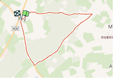
![](/images/other/stat-length.png)
![Randonnée Marche Bastogne - 11218235-Bastogne - Promenade Chemin des Pélerins - Photo](https://media.geolcdn.com/t/1900/400/ext.pjpeg?maxdim=2&url=https%3A%2F%2Fstatic1.geolcdn.com%2Fsiteimages%2Fupload%2Ffiles%2F1553511878bg_sport_marche.png)
11218235-Bastogne - Promenade Chemin des Pélerins
sophievdh
Utilisateur
![Longueur](/images/other/stat-length.png)
![Altitude max](https://static1.geolcdn.com/siteimages/upload/files/1508320355ic_sort_altitude_max_24dp.png)
![Dénivelé positif](https://static1.geolcdn.com/siteimages/upload/files/1508320355ic_sort_den_pos_24dp.png)
![Km-Effort](/images/other/stat-length.png)
![Altitude min](https://static1.geolcdn.com/siteimages/upload/files/1508320355ic_sort_altitude_min_24dp.png)
![Dénivelé négatif](https://static1.geolcdn.com/siteimages/upload/files/1508320355ic_sort_den_neg_24dp.png)
![Boucle](https://static1.geolcdn.com/siteimages/upload/files/16400158638029165_repeat_loop_refresh_sync_direction_icon.png)
![Marche](https://static1.geolcdn.com/sitytour/trail-icons/101.png)
2h12
Difficulté : Moyen
![Scannez ce code QR pour ouvrir la randonnée dans l'application SityTrail](https://capi.geolives.com/qq0zvz2zws4bq2lad0pu/sitytour/trails/2646686/qr.png?size=200)
Application GPS de randonnée GRATUITE
À propos
Randonnée Marche de 8 km à découvrir à Wallonie, Luxembourg, Bastogne. Cette randonnée est proposée par sophievdh.
Description
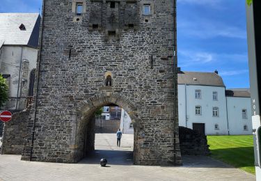
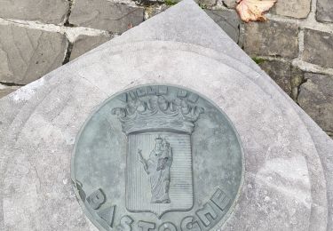
Balade proposée par le syndicat d'initiative de Bastogne
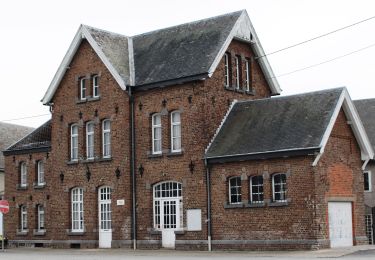
Départ de l’église de Foy
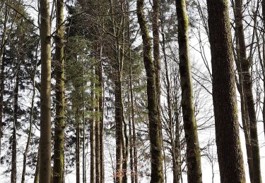
Le chemin des Pélerins est encore utilisé chaque année par des pèlerins allemands venus de Lendersorf. Cette contrée ayant connu une épidémie de rage, leurs ancêtres avaient fait le vœu d’aller en pèlerinage à Saint-Hubert si elle disparaissait . Ce chemin longe l’ancienne voie de chemin de fer où le talus présent est colonisé par l’alternance de zones herbeuses et arbustives, favorable à la nidification des passereaux ! Noisetiers, aubépines s’y portent à merveille
Localisation
Commentaires
Randonnées à proximité
![Randonnée Marche Bastogne - RF-Lu-07 - Entre prairies aux bisons et](https://media.geolcdn.com/t/375/260/ext.jpg?maxdim=2&url=https%3A%2F%2Fstatic1.geolcdn.com%2Fsiteimages%2Fupload%2Ffiles%2F1553511878bg_sport_marche.png)
![Marche Marche](https://static1.geolcdn.com/sitytour/trail-icons/101.png)
Marche
![](/images/other/stat-length.png)
![](https://static1.geolcdn.com/siteimages/upload/files/16400158638029165_repeat_loop_refresh_sync_direction_icon.png)
![Randonnée A pied Bastogne - Promenade de Sans-souci - Photo](https://media.geolcdn.com/t/375/260/7d0be711-2b6c-4626-95af-6f44538f00ad.jpeg&format=jpg&maxdim=2)
![A pied A pied](https://static1.geolcdn.com/sitytour/trail-icons/100.png)
A pied
![](/images/other/stat-length.png)
![](https://static1.geolcdn.com/siteimages/upload/files/16400158638029165_repeat_loop_refresh_sync_direction_icon.png)
![Randonnée A pied Bastogne - Promenade du chemin des Pélerins - Photo](https://media.geolcdn.com/t/375/260/2e9e462c-7e4b-4e66-b4b8-7cb92983120d.jpeg&format=jpg&maxdim=2)
![A pied A pied](https://static1.geolcdn.com/sitytour/trail-icons/100.png)
A pied
![](/images/other/stat-length.png)
![](https://static1.geolcdn.com/siteimages/upload/files/16400158638029165_repeat_loop_refresh_sync_direction_icon.png)
![Randonnée Marche Bastogne - Bastogne - MESA 2021 - Photo](https://media.geolcdn.com/t/375/260/7f6f41fe-3993-4cdf-90c5-d536a8644baf.jpg&format=jpg&maxdim=2)
![Marche Marche](https://static1.geolcdn.com/sitytour/trail-icons/101.png)
Marche
![](/images/other/stat-length.png)
![](https://static1.geolcdn.com/siteimages/upload/files/16400158638029165_repeat_loop_refresh_sync_direction_icon.png)
![Randonnée Marche Bastogne - Bastogne Mesa 280624 - Photo](https://media.geolcdn.com/t/375/260/21892c2e-ecf3-4b1b-9fd3-65a01c582f5a.jpg&format=jpg&maxdim=2)
![Marche Marche](https://static1.geolcdn.com/sitytour/trail-icons/101.png)
Marche
![](/images/other/stat-length.png)
![](https://static1.geolcdn.com/siteimages/upload/files/16400158638029165_repeat_loop_refresh_sync_direction_icon.png)
![Randonnée Marche Bastogne - route gen. patton in bastogne - Photo](https://media.geolcdn.com/t/375/260/08ba5daf-d3ce-4b66-8cef-496ca4dcfc13.jpg&format=jpg&maxdim=2)
![Marche Marche](https://static1.geolcdn.com/sitytour/trail-icons/101.png)
Marche
![](/images/other/stat-length.png)
![](https://static1.geolcdn.com/siteimages/upload/files/16400158638029165_repeat_loop_refresh_sync_direction_icon.png)
![Randonnée A pied Bastogne - Promenade du gros bois - Photo](https://media.geolcdn.com/t/375/260/ext.jpg?maxdim=2&url=https%3A%2F%2Fpivotmedia.tourismewallonie.be%2FOTH-A0-005K-1481%2FOTH-A0-005K-1481.jpg)
![A pied A pied](https://static1.geolcdn.com/sitytour/trail-icons/100.png)
A pied
![](/images/other/stat-length.png)
![](https://static1.geolcdn.com/siteimages/upload/files/16400158638029165_repeat_loop_refresh_sync_direction_icon.png)
![Randonnée A pied Bastogne - Promenade du Bois de la Paix - Photo](https://media.geolcdn.com/t/375/260/ext.jpg?maxdim=2&url=https%3A%2F%2Fpivotmedia.tourismewallonie.be%2FOTH-A0-005K-152P%2FOTH-A0-005K-152P.jpg)
![A pied A pied](https://static1.geolcdn.com/sitytour/trail-icons/100.png)
A pied
![](/images/other/stat-length.png)
![](https://static1.geolcdn.com/siteimages/upload/files/16400158638029165_repeat_loop_refresh_sync_direction_icon.png)
![Randonnée A pied Bastogne - Promenade du chemin des Pélerins - Photo](https://media.geolcdn.com/t/375/260/ext.jpg?maxdim=2&url=https%3A%2F%2Fpivotmedia.tourismewallonie.be%2FOTH-A0-005K-14UP%2FOTH-A0-005K-14UP.jpg)
![A pied A pied](https://static1.geolcdn.com/sitytour/trail-icons/100.png)
A pied
![](/images/other/stat-length.png)
![](https://static1.geolcdn.com/siteimages/upload/files/16400158638029165_repeat_loop_refresh_sync_direction_icon.png)