![](/images/other/stat-length.png)
![Randonnée Randonnée équestre Grandrieu - Etoile Charlotte - Photo](https://media.geolcdn.com/t/1900/400/ext.pjpeg?maxdim=2&url=https%3A%2F%2Fstatic1.geolcdn.com%2Fsiteimages%2Fupload%2Ffiles%2F1524743154cheval.jpg)
Etoile Charlotte
Lozère Cheval
Utilisateur
![Longueur](/images/other/stat-length.png)
Longueur
16,7 km
![Altitude max](https://static1.geolcdn.com/siteimages/upload/files/1508320355ic_sort_altitude_max_24dp.png)
Altitude max
1206 m
![Dénivelé positif](https://static1.geolcdn.com/siteimages/upload/files/1508320355ic_sort_den_pos_24dp.png)
Dénivelé positif
369 m
![Km-Effort](/images/other/stat-length.png)
Km-Effort
22 km
![Altitude min](https://static1.geolcdn.com/siteimages/upload/files/1508320355ic_sort_altitude_min_24dp.png)
Altitude min
1005 m
![Dénivelé négatif](https://static1.geolcdn.com/siteimages/upload/files/1508320355ic_sort_den_neg_24dp.png)
Dénivelé négatif
371 m
![Boucle](https://static1.geolcdn.com/siteimages/upload/files/16400158638029165_repeat_loop_refresh_sync_direction_icon.png)
Boucle
Oui
Date de création :
2021-01-15 15:43:10.617
Dernière modification :
2021-01-15 15:43:50.097
![Randonnée équestre](https://static1.geolcdn.com/sitytour/trail-icons/301.png)
2h50
Difficulté : Moyen
![Scannez ce code QR pour ouvrir la randonnée dans l'application SityTrail](https://capi.geolives.com/qq0zvz2zws4bq2lad0pu/sitytour/trails/2641353/qr.png?size=200)
Application GPS de randonnée GRATUITE
À propos
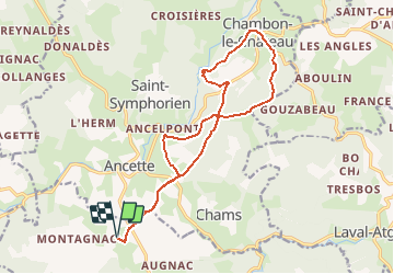
Randonnée Randonnée équestre de 16,7 km à découvrir à Occitanie, Lozère, Grandrieu. Cette randonnée est proposée par Lozère Cheval.
Description
8807522-VC MAZIMBERT MALVIALA CHAMBON GAUZABEAU
Localisation
Pays :
France
Région :
Occitanie
Département/Province :
Lozère
Commune :
Grandrieu
Localité :
Unknown
Départ:(Dec)
Départ:(UTM)
548678 ; 4961779 (31T) N.
Commentaires
Randonnées à proximité
![Randonnée Marche Bel-Air-Val-d'Ance - chambon le chateau - Photo](https://media.geolcdn.com/t/375/260/ext.jpg?maxdim=2&url=https%3A%2F%2Fstatic1.geolcdn.com%2Fsiteimages%2Fupload%2Ffiles%2F1553511878bg_sport_marche.png)
![Marche Marche](https://static1.geolcdn.com/sitytour/trail-icons/101.png)
chambon le chateau
Marche
Moyen
Bel-Air-Val-d'Ance,
Occitanie,
Lozère,
France
![](/images/other/stat-length.png)
8,7 km | 10,9 km-effort
2h 18min
![](https://static1.geolcdn.com/siteimages/upload/files/16400158638029165_repeat_loop_refresh_sync_direction_icon.png)
Oui
![Randonnée sport Grandrieu - 2 bouviers - Photo](https://media.geolcdn.com/t/375/260/ext.jpg?maxdim=2&url=https%3A%2F%2Fsecurestorage.geolives.com%2Fsitytour%2Ftrail-bg%2Fdefault.jpg)
2 bouviers
sport
Très facile
Grandrieu,
Occitanie,
Lozère,
France
![](/images/other/stat-length.png)
17,2 km | 23 km-effort
Inconnu
![](https://static1.geolcdn.com/siteimages/upload/files/16400158638029165_repeat_loop_refresh_sync_direction_icon.png)
Non
![Randonnée Randonnée équestre Grandrieu - Etoile de Mazimbert - Photo](https://media.geolcdn.com/t/375/260/ext.jpg?maxdim=2&url=https%3A%2F%2Fstatic1.geolcdn.com%2Fsiteimages%2Fupload%2Ffiles%2F1524743154cheval.jpg)
![Randonnée équestre Randonnée équestre](https://static1.geolcdn.com/sitytour/trail-icons/301.png)
Etoile de Mazimbert
Randonnée équestre
Moyen
Grandrieu,
Occitanie,
Lozère,
France
![](/images/other/stat-length.png)
21 km | 28 km-effort
3h 38min
![](https://static1.geolcdn.com/siteimages/upload/files/16400158638029165_repeat_loop_refresh_sync_direction_icon.png)
Oui
![Randonnée Randonnée équestre Grandrieu - Etoile des Bouviers - Photo](https://media.geolcdn.com/t/375/260/ext.jpg?maxdim=2&url=https%3A%2F%2Fstatic1.geolcdn.com%2Fsiteimages%2Fupload%2Ffiles%2F1524743154cheval.jpg)
![Randonnée équestre Randonnée équestre](https://static1.geolcdn.com/sitytour/trail-icons/301.png)
Etoile des Bouviers
Randonnée équestre
Très difficile
Grandrieu,
Occitanie,
Lozère,
France
![](/images/other/stat-length.png)
38 km | 50 km-effort
6h 31min
![](https://static1.geolcdn.com/siteimages/upload/files/16400158638029165_repeat_loop_refresh_sync_direction_icon.png)
Oui
![Randonnée Randonnée équestre Grandrieu - Etoile Boisée - Photo](https://media.geolcdn.com/t/375/260/ext.jpg?maxdim=2&url=https%3A%2F%2Fstatic1.geolcdn.com%2Fsiteimages%2Fupload%2Ffiles%2F1524743154cheval.jpg)
![Randonnée équestre Randonnée équestre](https://static1.geolcdn.com/sitytour/trail-icons/301.png)
Etoile Boisée
Randonnée équestre
Difficile
Grandrieu,
Occitanie,
Lozère,
France
![](/images/other/stat-length.png)
24 km | 32 km-effort
4h 14min
![](https://static1.geolcdn.com/siteimages/upload/files/16400158638029165_repeat_loop_refresh_sync_direction_icon.png)
Oui
![Randonnée Randonnée équestre Grandrieu - Etoile des Fangouses - Photo](https://media.geolcdn.com/t/375/260/ext.jpg?maxdim=2&url=https%3A%2F%2Fstatic1.geolcdn.com%2Fsiteimages%2Fupload%2Ffiles%2F1524743154cheval.jpg)
![Randonnée équestre Randonnée équestre](https://static1.geolcdn.com/sitytour/trail-icons/301.png)
Etoile des Fangouses
Randonnée équestre
Moyen
Grandrieu,
Occitanie,
Lozère,
France
![](/images/other/stat-length.png)
17,8 km | 23 km-effort
3h 4min
![](https://static1.geolcdn.com/siteimages/upload/files/16400158638029165_repeat_loop_refresh_sync_direction_icon.png)
Oui
![Randonnée Randonnée équestre Grandrieu - Etoile Chacha - Photo](https://media.geolcdn.com/t/375/260/ext.jpg?maxdim=2&url=https%3A%2F%2Fstatic1.geolcdn.com%2Fsiteimages%2Fupload%2Ffiles%2F1524743154cheval.jpg)
![Randonnée équestre Randonnée équestre](https://static1.geolcdn.com/sitytour/trail-icons/301.png)
Etoile Chacha
Randonnée équestre
Moyen
Grandrieu,
Occitanie,
Lozère,
France
![](/images/other/stat-length.png)
17,6 km | 22 km-effort
2h 55min
![](https://static1.geolcdn.com/siteimages/upload/files/16400158638029165_repeat_loop_refresh_sync_direction_icon.png)
Oui
![Randonnée Marche Saint-Paul-le-Froid - le chayla d ance - Photo](https://media.geolcdn.com/t/375/260/ext.jpg?maxdim=2&url=https%3A%2F%2Fstatic1.geolcdn.com%2Fsiteimages%2Fupload%2Ffiles%2F1553511878bg_sport_marche.png)
![Marche Marche](https://static1.geolcdn.com/sitytour/trail-icons/101.png)
le chayla d ance
Marche
Très facile
Saint-Paul-le-Froid,
Occitanie,
Lozère,
France
![](/images/other/stat-length.png)
8,9 km | 11,4 km-effort
3h 1min
![](https://static1.geolcdn.com/siteimages/upload/files/16400158638029165_repeat_loop_refresh_sync_direction_icon.png)
Non
![Randonnée Randonnée équestre Grandrieu - Etoile des Producteurs mazimbert boucle mazimbert 3 - Photo](https://media.geolcdn.com/t/375/260/ext.jpg?maxdim=2&url=https%3A%2F%2Fstatic1.geolcdn.com%2Fsiteimages%2Fupload%2Ffiles%2F1524743154cheval.jpg)
![Randonnée équestre Randonnée équestre](https://static1.geolcdn.com/sitytour/trail-icons/301.png)
Etoile des Producteurs mazimbert boucle mazimbert 3
Randonnée équestre
Moyen
Grandrieu,
Occitanie,
Lozère,
France
![](/images/other/stat-length.png)
21 km | 28 km-effort
3h 29min
![](https://static1.geolcdn.com/siteimages/upload/files/16400158638029165_repeat_loop_refresh_sync_direction_icon.png)
Oui