![](/images/other/stat-length.png)
![Randonnée Randonnée équestre La Tieule - Etoile de Barennes - Photo](https://media.geolcdn.com/t/1900/400/ext.pjpeg?maxdim=2&url=https%3A%2F%2Fstatic1.geolcdn.com%2Fsiteimages%2Fupload%2Ffiles%2F1524743154cheval.jpg)
Etoile de Barennes
Lozère Cheval
Utilisateur
![Longueur](/images/other/stat-length.png)
Longueur
26 km
![Altitude max](https://static1.geolcdn.com/siteimages/upload/files/1508320355ic_sort_altitude_max_24dp.png)
Altitude max
956 m
![Dénivelé positif](https://static1.geolcdn.com/siteimages/upload/files/1508320355ic_sort_den_pos_24dp.png)
Dénivelé positif
728 m
![Km-Effort](/images/other/stat-length.png)
Km-Effort
36 km
![Altitude min](https://static1.geolcdn.com/siteimages/upload/files/1508320355ic_sort_altitude_min_24dp.png)
Altitude min
770 m
![Dénivelé négatif](https://static1.geolcdn.com/siteimages/upload/files/1508320355ic_sort_den_neg_24dp.png)
Dénivelé négatif
738 m
![Boucle](https://static1.geolcdn.com/siteimages/upload/files/16400158638029165_repeat_loop_refresh_sync_direction_icon.png)
Boucle
Oui
Date de création :
2021-01-15 15:23:09.161
Dernière modification :
2021-01-15 15:23:59.451
![Randonnée équestre](https://static1.geolcdn.com/sitytour/trail-icons/301.png)
4h45
Difficulté : Difficile
![Scannez ce code QR pour ouvrir la randonnée dans l'application SityTrail](https://capi.geolives.com/qq0zvz2zws4bq2lad0pu/sitytour/trails/2641309/qr.png?size=200)
Application GPS de randonnée GRATUITE
À propos
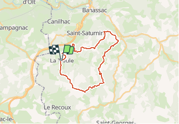
Randonnée Randonnée équestre de 26 km à découvrir à Occitanie, Lozère, La Tieule. Cette randonnée est proposée par Lozère Cheval.
Description
La Tieule en passant par Mas de Donat, Rouget Parets, Gauzines, Maynard, Betones, Esquino d'Aze Retour La Tieule
Localisation
Pays :
France
Région :
Occitanie
Département/Province :
Lozère
Commune :
La Tieule
Localité :
Unknown
Départ:(Dec)
Départ:(UTM)
512443 ; 4914570 (31T) N.
Commentaires
Randonnées à proximité
![Randonnée Marche La Canourgue - Dessus la canourgue - Photo](https://media.geolcdn.com/t/375/260/30a5f5a0-e728-45ed-9aed-a3cadcaf9c1d.jpg&format=jpg&maxdim=2)
![Marche Marche](https://static1.geolcdn.com/sitytour/trail-icons/101.png)
Dessus la canourgue
Marche
Difficile
La Canourgue,
Occitanie,
Lozère,
France
![](/images/other/stat-length.png)
9,1 km | 14,4 km-effort
3h 48min
![](https://static1.geolcdn.com/siteimages/upload/files/16400158638029165_repeat_loop_refresh_sync_direction_icon.png)
Non
![Randonnée Marche Saint-Saturnin - Vers l'antenne de La Canourgue - Photo](https://media.geolcdn.com/t/375/260/04a5ad93-a1c4-4dbe-97ad-0dc573f357dc.jpg&format=jpg&maxdim=2)
![Marche Marche](https://static1.geolcdn.com/sitytour/trail-icons/101.png)
Vers l'antenne de La Canourgue
Marche
Facile
Saint-Saturnin,
Occitanie,
Lozère,
France
![](/images/other/stat-length.png)
6,9 km | 8,8 km-effort
1h 42min
![](https://static1.geolcdn.com/siteimages/upload/files/16400158638029165_repeat_loop_refresh_sync_direction_icon.png)
Oui
![Randonnée sport La Canourgue - Ta dimanche - Photo](https://media.geolcdn.com/t/375/260/ext.jpg?maxdim=2&url=https%3A%2F%2Fsecurestorage.geolives.com%2Fsitytour%2Ftrail-bg%2Fdefault.jpg)
Ta dimanche
sport
Très facile
La Canourgue,
Occitanie,
Lozère,
France
![](/images/other/stat-length.png)
108 km | 142 km-effort
Inconnu
![](https://static1.geolcdn.com/siteimages/upload/files/16400158638029165_repeat_loop_refresh_sync_direction_icon.png)
Non
![Randonnée Randonnée équestre La Tieule - Etoile de Sauveterre - Photo](https://media.geolcdn.com/t/375/260/ext.jpg?maxdim=2&url=https%3A%2F%2Fstatic1.geolcdn.com%2Fsiteimages%2Fupload%2Ffiles%2F1524743154cheval.jpg)
![Randonnée équestre Randonnée équestre](https://static1.geolcdn.com/sitytour/trail-icons/301.png)
Etoile de Sauveterre
Randonnée équestre
Difficile
La Tieule,
Occitanie,
Lozère,
France
![](/images/other/stat-length.png)
27 km | 37 km-effort
4h 53min
![](https://static1.geolcdn.com/siteimages/upload/files/16400158638029165_repeat_loop_refresh_sync_direction_icon.png)
Oui
![Randonnée Randonnée équestre La Tieule - Etoile de Coustaracos - Photo](https://media.geolcdn.com/t/375/260/ext.jpg?maxdim=2&url=https%3A%2F%2Fstatic1.geolcdn.com%2Fsiteimages%2Fupload%2Ffiles%2F1524743154cheval.jpg)
![Randonnée équestre Randonnée équestre](https://static1.geolcdn.com/sitytour/trail-icons/301.png)
Etoile de Coustaracos
Randonnée équestre
Très difficile
La Tieule,
Occitanie,
Lozère,
France
![](/images/other/stat-length.png)
29 km | 42 km-effort
5h 33min
![](https://static1.geolcdn.com/siteimages/upload/files/16400158638029165_repeat_loop_refresh_sync_direction_icon.png)
Oui
![Randonnée Marche La Tieule - Chemin de St Guilhem - La Tieule - Saint Georges de Lévéjac - Photo](https://media.geolcdn.com/t/375/260/ext.jpg?maxdim=2&url=https%3A%2F%2Fstatic1.geolcdn.com%2Fsiteimages%2Fupload%2Ffiles%2F1553511878bg_sport_marche.png)
![Marche Marche](https://static1.geolcdn.com/sitytour/trail-icons/101.png)
Chemin de St Guilhem - La Tieule - Saint Georges de Lévéjac
Marche
Très difficile
La Tieule,
Occitanie,
Lozère,
France
![](/images/other/stat-length.png)
21 km | 28 km-effort
5h 56min
![](https://static1.geolcdn.com/siteimages/upload/files/16400158638029165_repeat_loop_refresh_sync_direction_icon.png)
Non
![Randonnée Randonnée équestre La Tieule - Grande Boucle Tieule/Canourgue/Champerboux/StEnimie/MasRouch/Tieule - Photo](https://media.geolcdn.com/t/375/260/ext.jpg?maxdim=2&url=https%3A%2F%2Fstatic1.geolcdn.com%2Fsiteimages%2Fupload%2Ffiles%2F1524743154cheval.jpg)
![Randonnée équestre Randonnée équestre](https://static1.geolcdn.com/sitytour/trail-icons/301.png)
Grande Boucle Tieule/Canourgue/Champerboux/StEnimie/MasRouch/Tieule
Randonnée équestre
Très difficile
La Tieule,
Occitanie,
Lozère,
France
![](/images/other/stat-length.png)
91 km | 123 km-effort
15h 4min
![](https://static1.geolcdn.com/siteimages/upload/files/16400158638029165_repeat_loop_refresh_sync_direction_icon.png)
Oui
![Randonnée Randonnée équestre La Tieule - Boucle La Canourgue/ La Tieule / Mas Rouch - Photo](https://media.geolcdn.com/t/375/260/ext.jpg?maxdim=2&url=https%3A%2F%2Fstatic1.geolcdn.com%2Fsiteimages%2Fupload%2Ffiles%2F1524743154cheval.jpg)
![Randonnée équestre Randonnée équestre](https://static1.geolcdn.com/sitytour/trail-icons/301.png)
Boucle La Canourgue/ La Tieule / Mas Rouch
Randonnée équestre
Très facile
La Tieule,
Occitanie,
Lozère,
France
![](/images/other/stat-length.png)
66 km | 91 km-effort
Inconnu
![](https://static1.geolcdn.com/siteimages/upload/files/16400158638029165_repeat_loop_refresh_sync_direction_icon.png)
Oui
![Randonnée Marche Campagnac - Campagnac - Photo](https://media.geolcdn.com/t/375/260/ext.jpg?maxdim=2&url=https%3A%2F%2Fstatic1.geolcdn.com%2Fsiteimages%2Fupload%2Ffiles%2F1553511878bg_sport_marche.png)
![Marche Marche](https://static1.geolcdn.com/sitytour/trail-icons/101.png)
Campagnac
Marche
Très facile
Campagnac,
Occitanie,
Aveyron,
France
![](/images/other/stat-length.png)
14 km | 17,9 km-effort
5h 52min
![](https://static1.geolcdn.com/siteimages/upload/files/16400158638029165_repeat_loop_refresh_sync_direction_icon.png)
Oui