![](/images/other/stat-length.png)
![Randonnée Marche Welkenraedt - Henri-Chapelle - La Clouse - Cimetière Américain - Gulpen - Bois de Hees - Photo](https://media.geolcdn.com/t/1900/400/ext.pjpeg?maxdim=2&url=https%3A%2F%2Fstatic1.geolcdn.com%2Fsiteimages%2Fupload%2Ffiles%2F1553511878bg_sport_marche.png)
Henri-Chapelle - La Clouse - Cimetière Américain - Gulpen - Bois de Hees
emoreau
Utilisateur
![Longueur](/images/other/stat-length.png)
Longueur
11,2 km
![Altitude max](https://static1.geolcdn.com/siteimages/upload/files/1508320355ic_sort_altitude_max_24dp.png)
Altitude max
353 m
![Dénivelé positif](https://static1.geolcdn.com/siteimages/upload/files/1508320355ic_sort_den_pos_24dp.png)
Dénivelé positif
203 m
![Km-Effort](/images/other/stat-length.png)
Km-Effort
13,9 km
![Altitude min](https://static1.geolcdn.com/siteimages/upload/files/1508320355ic_sort_altitude_min_24dp.png)
Altitude min
254 m
![Dénivelé négatif](https://static1.geolcdn.com/siteimages/upload/files/1508320355ic_sort_den_neg_24dp.png)
Dénivelé négatif
202 m
![Boucle](https://static1.geolcdn.com/siteimages/upload/files/16400158638029165_repeat_loop_refresh_sync_direction_icon.png)
Boucle
Oui
Date de création :
2021-01-10 12:42:12.074
Dernière modification :
2021-01-11 19:56:28.666
![Marche](https://static1.geolcdn.com/sitytour/trail-icons/101.png)
3h46
Difficulté : Très facile
![Scannez ce code QR pour ouvrir la randonnée dans l'application SityTrail](https://capi.geolives.com/qq0zvz2zws4bq2lad0pu/sitytour/trails/2638658/qr.png?size=200)
Application GPS de randonnée GRATUITE
À propos
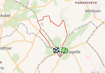
Randonnée Marche de 11,2 km à découvrir à Wallonie, Liège, Welkenraedt. Cette randonnée est proposée par emoreau.
Description
Belle promenade avec panorama sur le pays de Herve, visite du cimetière Américain de Henri-Chapelle, descente sur la vallée de la Gulpen puis retour en suivant la lisière du bois de Hees.
Localisation
Pays :
Belgique
Région :
Wallonie
Département/Province :
Liège
Commune :
Welkenraedt
Localité :
Henri-Chapelle
Départ:(Dec)
Départ:(UTM)
706574 ; 5617553 (31U) N.
Commentaires
Randonnées à proximité
![Randonnée Marche Thimister-Clermont - Froidthier - Photo](https://media.geolcdn.com/t/375/260/ext.jpg?maxdim=2&url=https%3A%2F%2Fmedia.geolcdn.com%2Ff%2F9142f7fe-feb5-4533-8005-65992f1c4338.jpg)
![Marche Marche](https://static1.geolcdn.com/sitytour/trail-icons/101.png)
Froidthier
Marche
Facile
(1)
Thimister-Clermont,
Wallonie,
Liège,
Belgique
![](/images/other/stat-length.png)
6,6 km | 7,9 km-effort
1h 48min
![](https://static1.geolcdn.com/siteimages/upload/files/16400158638029165_repeat_loop_refresh_sync_direction_icon.png)
Oui
![Randonnée Marche Baelen - Baelen - Eupen 🎄🎅 - Membach - Photo](https://media.geolcdn.com/t/375/260/ext.jpg?maxdim=2&url=https%3A%2F%2Fmedia.geolcdn.com%2Ff%2Fd50227a7-424d-470e-90d5-87ebd384de36.jpg)
![Marche Marche](https://static1.geolcdn.com/sitytour/trail-icons/101.png)
Baelen - Eupen 🎄🎅 - Membach
Marche
Facile
(1)
Baelen,
Wallonie,
Liège,
Belgique
![](/images/other/stat-length.png)
13,3 km | 15,6 km-effort
3h 32min
![](https://static1.geolcdn.com/siteimages/upload/files/16400158638029165_repeat_loop_refresh_sync_direction_icon.png)
Oui
![Randonnée Marche Plombières - 20220428 - Bois de Hess 6.7 Km - Photo](https://media.geolcdn.com/t/375/260/ext.jpg?maxdim=2&url=https%3A%2F%2Fmedia.geolcdn.com%2Ff%2Fa5b9728a-379a-44f7-9b32-760730404ded.JPG)
![Marche Marche](https://static1.geolcdn.com/sitytour/trail-icons/101.png)
20220428 - Bois de Hess 6.7 Km
Marche
Moyen
(1)
Plombières,
Wallonie,
Liège,
Belgique
![](/images/other/stat-length.png)
6,7 km | 8,4 km-effort
3h 11min
![](https://static1.geolcdn.com/siteimages/upload/files/16400158638029165_repeat_loop_refresh_sync_direction_icon.png)
Oui
![Randonnée Marche Lontzen - Herbesthal - Photo](https://media.geolcdn.com/t/375/260/ext.jpg?maxdim=2&url=https%3A%2F%2Fmedia.geolcdn.com%2Ff%2Ff329bf39-b33b-4890-a8af-1e7d956ba015.jpg)
![Marche Marche](https://static1.geolcdn.com/sitytour/trail-icons/101.png)
Herbesthal
Marche
Facile
(2)
Lontzen,
Wallonie,
Liège,
Belgique
![](/images/other/stat-length.png)
13,4 km | 15,8 km-effort
3h 35min
![](https://static1.geolcdn.com/siteimages/upload/files/16400158638029165_repeat_loop_refresh_sync_direction_icon.png)
Oui
![Randonnée Marche Aubel - RB-Lg-04_Aubel_via-racc - Photo](https://media.geolcdn.com/t/375/260/ext.jpg?maxdim=2&url=https%3A%2F%2Fservices.sitytrail.com%2FGeolivesWS%2FDownloadMedia.ashx%3FTrailID%3D209393%26Media%3D9ac6c0af-9a08-4948-b5d5-06a09e8ba132.jpg)
![Marche Marche](https://static1.geolcdn.com/sitytour/trail-icons/101.png)
RB-Lg-04_Aubel_via-racc
Marche
Moyen
(3)
Aubel,
Wallonie,
Liège,
Belgique
![](/images/other/stat-length.png)
17,1 km | 22 km-effort
4h 50min
![](https://static1.geolcdn.com/siteimages/upload/files/16400158638029165_repeat_loop_refresh_sync_direction_icon.png)
Oui
![Randonnée V.T.T. Aubel - AUBEL et FOURONS - Photo](https://media.geolcdn.com/t/375/260/ext.jpg?maxdim=2&url=https%3A%2F%2Fmedia.geolcdn.com%2Ff%2Fdb368aa7-ef51-4c2a-90d2-a8cae2117bc2.jpg)
![V.T.T. V.T.T.](https://static1.geolcdn.com/sitytour/trail-icons/202.png)
AUBEL et FOURONS
V.T.T.
Très difficile
(2)
Aubel,
Wallonie,
Liège,
Belgique
![](/images/other/stat-length.png)
42 km | 55 km-effort
5h 8min
![](https://static1.geolcdn.com/siteimages/upload/files/16400158638029165_repeat_loop_refresh_sync_direction_icon.png)
Oui
![Randonnée Marche Aubel - Aubel, Tossem, Helestrop - Photo](https://media.geolcdn.com/t/375/260/ext.jpg?maxdim=2&url=https%3A%2F%2Fservices.sitytrail.com%2FGeolivesWS%2FDownloadMedia.ashx%3FTrailID%3D643850%26Media%3D20161009164230.jpg)
![Marche Marche](https://static1.geolcdn.com/sitytour/trail-icons/101.png)
Aubel, Tossem, Helestrop
Marche
Très facile
(1)
Aubel,
Wallonie,
Liège,
Belgique
![](/images/other/stat-length.png)
9,9 km | 12 km-effort
2h 44min
![](https://static1.geolcdn.com/siteimages/upload/files/16400158638029165_repeat_loop_refresh_sync_direction_icon.png)
Oui
![Randonnée Marche Welkenraedt - Promenade des deux Châteaux (5km) - Photo](https://media.geolcdn.com/t/375/260/ext.jpg?maxdim=2&url=https%3A%2F%2Fstatic1.geolcdn.com%2Fsiteimages%2Fupload%2Ffiles%2F1553511878bg_sport_marche.png)
![Marche Marche](https://static1.geolcdn.com/sitytour/trail-icons/101.png)
Promenade des deux Châteaux (5km)
Marche
Très facile
(2)
Welkenraedt,
Wallonie,
Liège,
Belgique
![](/images/other/stat-length.png)
5,4 km | 6 km-effort
Inconnu
![](https://static1.geolcdn.com/siteimages/upload/files/16400158638029165_repeat_loop_refresh_sync_direction_icon.png)
Oui
![Randonnée Marche Thimister-Clermont - 12km froidthier crawhez oct23 à faire - Photo](https://media.geolcdn.com/t/375/260/ext.jpg?maxdim=2&url=https%3A%2F%2Fstatic1.geolcdn.com%2Fsiteimages%2Fupload%2Ffiles%2F1553511878bg_sport_marche.png)
![Marche Marche](https://static1.geolcdn.com/sitytour/trail-icons/101.png)
12km froidthier crawhez oct23 à faire
Marche
Difficile
(1)
Thimister-Clermont,
Wallonie,
Liège,
Belgique
![](/images/other/stat-length.png)
11,9 km | 14,4 km-effort
3h 17min
![](https://static1.geolcdn.com/siteimages/upload/files/16400158638029165_repeat_loop_refresh_sync_direction_icon.png)
Oui