![](/images/other/stat-length.png)
![Randonnée Marche Watermael-Boitsfort - Forêt de Soignes - Photo](https://media.geolcdn.com/t/1900/400/f866c0e9-2751-4291-8342-e8e52d4b6bd1.jpg&format=pjpeg&maxdim=2)
Forêt de Soignes
beautrix
Utilisateur
![Longueur](/images/other/stat-length.png)
Longueur
12,2 km
![Altitude max](https://static1.geolcdn.com/siteimages/upload/files/1508320355ic_sort_altitude_max_24dp.png)
Altitude max
150 m
![Dénivelé positif](https://static1.geolcdn.com/siteimages/upload/files/1508320355ic_sort_den_pos_24dp.png)
Dénivelé positif
197 m
![Km-Effort](/images/other/stat-length.png)
Km-Effort
14,8 km
![Altitude min](https://static1.geolcdn.com/siteimages/upload/files/1508320355ic_sort_altitude_min_24dp.png)
Altitude min
80 m
![Dénivelé négatif](https://static1.geolcdn.com/siteimages/upload/files/1508320355ic_sort_den_neg_24dp.png)
Dénivelé négatif
199 m
![Boucle](https://static1.geolcdn.com/siteimages/upload/files/16400158638029165_repeat_loop_refresh_sync_direction_icon.png)
Boucle
Oui
Date de création :
2020-12-29 09:16:49.181
Dernière modification :
2020-12-30 09:47:40.024
![Marche](https://static1.geolcdn.com/sitytour/trail-icons/101.png)
3h03
Difficulté : Très facile
![Scannez ce code QR pour ouvrir la randonnée dans l'application SityTrail](https://capi.geolives.com/qq0zvz2zws4bq2lad0pu/sitytour/trails/2627604/qr.png?size=200)
Application GPS de randonnée GRATUITE
À propos
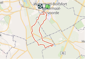
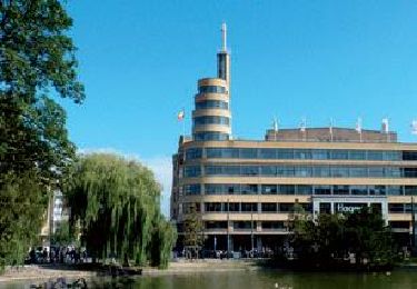
Randonnée Marche de 12,2 km à découvrir à Bruxelles-Capitale, Inconnu, Watermael-Boitsfort. Cette randonnée est proposée par beautrix.
Description
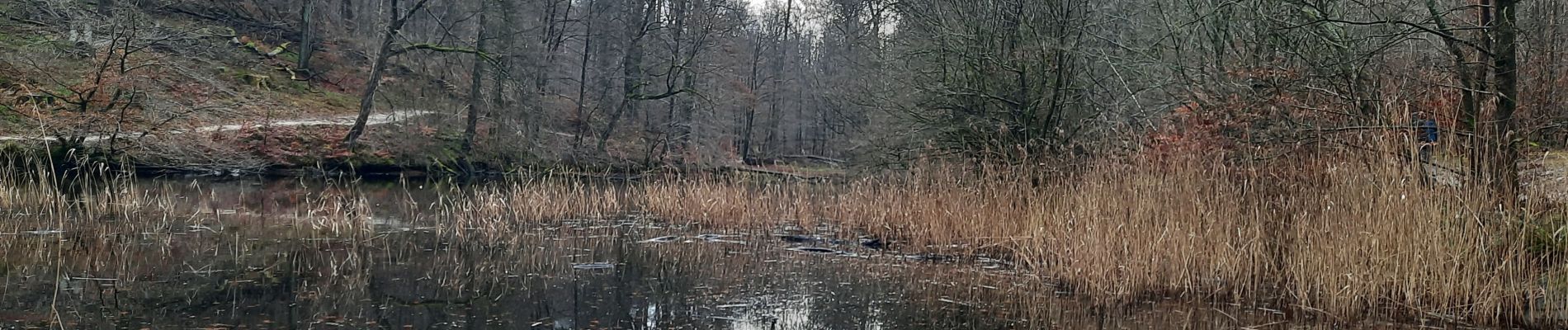
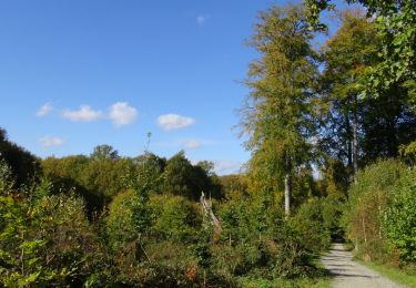
Départ de la gare de Boisfort... Balade à travers forêt et étangs. De beaux sentiers serpentant le long de petits ruisseaux encaissés, cette promenade facile permet de s'évader à quelques pas de Bruxelles ville !
Localisation
Pays :
Belgique
Région :
Bruxelles-Capitale
Département/Province :
Inconnu
Commune :
Watermael-Boitsfort
Localité :
Watermael-Boitsfort
Départ:(Dec)
Départ:(UTM)
599313 ; 5627921 (31U) N.
Commentaires
Randonnées à proximité
![Randonnée Marche Hoeilaert - RL-GG-04_Hoielart_Genval - Photo](https://media.geolcdn.com/t/375/260/364592d0-bbf8-45ce-9ea9-708b8ca7581f.jpg&format=jpg&maxdim=2)
![Marche Marche](https://static1.geolcdn.com/sitytour/trail-icons/101.png)
RL-GG-04_Hoielart_Genval
Marche
Très difficile
(6)
Hoeilaert,
Flandre,
Brabant flamand,
Belgique
![](/images/other/stat-length.png)
23 km | 28 km-effort
5h 54min
![](https://static1.geolcdn.com/siteimages/upload/files/16400158638029165_repeat_loop_refresh_sync_direction_icon.png)
Non
![Randonnée Marche Auderghem - RB-Br-10-Rac02 - Photo](https://media.geolcdn.com/t/375/260/ext.jpg?maxdim=2&url=https%3A%2F%2Fservices.sitytrail.com%2FGeolivesWS%2FDownloadMedia.ashx%3FTrailID%3D247907%26Media%3Db30f5581-2af5-47b0-aca2-8f9cddfbea28.jpg)
![Marche Marche](https://static1.geolcdn.com/sitytour/trail-icons/101.png)
RB-Br-10-Rac02
Marche
Facile
(10)
Auderghem,
Bruxelles-Capitale,
Inconnu,
Belgique
![](/images/other/stat-length.png)
13,6 km | 16,2 km-effort
3h 40min
![](https://static1.geolcdn.com/siteimages/upload/files/16400158638029165_repeat_loop_refresh_sync_direction_icon.png)
Oui
![Randonnée Marche Auderghem - RB-Br-09 Rac02 - Photo](https://media.geolcdn.com/t/375/260/ext.jpg?maxdim=2&url=https%3A%2F%2Fservices.sitytrail.com%2FGeolivesWS%2FDownloadMedia.ashx%3FTrailID%3D247903%26Media%3D4f2f6ef8-5647-4df5-b72e-d8a55c5e5b6f.jpg)
![Marche Marche](https://static1.geolcdn.com/sitytour/trail-icons/101.png)
RB-Br-09 Rac02
Marche
Facile
(9)
Auderghem,
Bruxelles-Capitale,
Inconnu,
Belgique
![](/images/other/stat-length.png)
15,3 km | 18 km-effort
4h 5min
![](https://static1.geolcdn.com/siteimages/upload/files/16400158638029165_repeat_loop_refresh_sync_direction_icon.png)
Oui
![Randonnée Marche Auderghem - RB-Br-09 - Photo](https://media.geolcdn.com/t/375/260/ext.jpg?maxdim=2&url=https%3A%2F%2Fservices.sitytrail.com%2FGeolivesWS%2FDownloadMedia.ashx%3FTrailID%3D247899%26Media%3D7b6d3a4f-3999-4d35-8f7d-f23163489b77.jpg)
![Marche Marche](https://static1.geolcdn.com/sitytour/trail-icons/101.png)
RB-Br-09
Marche
Moyen
(8)
Auderghem,
Bruxelles-Capitale,
Inconnu,
Belgique
![](/images/other/stat-length.png)
20 km | 25 km-effort
5h 34min
![](https://static1.geolcdn.com/siteimages/upload/files/16400158638029165_repeat_loop_refresh_sync_direction_icon.png)
Oui
![Randonnée V.T.T. Uccle - O2bikers_33_foret_de_Soignes - Photo](https://media.geolcdn.com/t/375/260/ext.jpg?maxdim=2&url=https%3A%2F%2Fstatic1.geolcdn.com%2Fsiteimages%2Fupload%2Ffiles%2F1524743154velo.jpg)
![V.T.T. V.T.T.](https://static1.geolcdn.com/sitytour/trail-icons/202.png)
O2bikers_33_foret_de_Soignes
V.T.T.
Très facile
(8)
Uccle,
Bruxelles-Capitale,
Inconnu,
Belgique
![](/images/other/stat-length.png)
25 km | 30 km-effort
3h 18min
![](https://static1.geolcdn.com/siteimages/upload/files/16400158638029165_repeat_loop_refresh_sync_direction_icon.png)
Oui
![Randonnée Marche Uccle - Balade en Forêt de Soignes - Photo](https://media.geolcdn.com/t/375/260/ext.jpg?maxdim=2&url=https%3A%2F%2Fservices.sitytrail.com%2FGeolivesWS%2FDownloadMedia.ashx%3FTrailID%3D356191%26Media%3D75102304-4aad-42f5-b9c6-44db447eb5dc.JPG)
![Marche Marche](https://static1.geolcdn.com/sitytour/trail-icons/101.png)
Balade en Forêt de Soignes
Marche
Facile
(5)
Uccle,
Bruxelles-Capitale,
Inconnu,
Belgique
![](/images/other/stat-length.png)
9,1 km | 11,2 km-effort
2h 24min
![](https://static1.geolcdn.com/siteimages/upload/files/16400158638029165_repeat_loop_refresh_sync_direction_icon.png)
Oui
![Randonnée Marche Auderghem - RB-Br-10 - Photo](https://media.geolcdn.com/t/375/260/ext.jpg?maxdim=2&url=https%3A%2F%2Fservices.sitytrail.com%2FGeolivesWS%2FDownloadMedia.ashx%3FTrailID%3D247904%26Media%3Db30f5581-2af5-47b0-aca2-8f9cddfbea28.jpg)
![Marche Marche](https://static1.geolcdn.com/sitytour/trail-icons/101.png)
RB-Br-10
Marche
Moyen
(4)
Auderghem,
Bruxelles-Capitale,
Inconnu,
Belgique
![](/images/other/stat-length.png)
21 km | 25 km-effort
5h 38min
![](https://static1.geolcdn.com/siteimages/upload/files/16400158638029165_repeat_loop_refresh_sync_direction_icon.png)
Oui
![Randonnée Marche Auderghem - RB-Br-09 Rac01 - Photo](https://media.geolcdn.com/t/375/260/ext.jpg?maxdim=2&url=https%3A%2F%2Fservices.sitytrail.com%2FGeolivesWS%2FDownloadMedia.ashx%3FTrailID%3D247901%26Media%3D4f2f6ef8-5647-4df5-b72e-d8a55c5e5b6f.jpg)
![Marche Marche](https://static1.geolcdn.com/sitytour/trail-icons/101.png)
RB-Br-09 Rac01
Marche
Facile
(4)
Auderghem,
Bruxelles-Capitale,
Inconnu,
Belgique
![](/images/other/stat-length.png)
16 km | 19,1 km-effort
4h 20min
![](https://static1.geolcdn.com/siteimages/upload/files/16400158638029165_repeat_loop_refresh_sync_direction_icon.png)
Oui
![Randonnée Marche Saint-Gilles - RB-Br-08-via raccourci - Photo](https://media.geolcdn.com/t/375/260/ext.jpg?maxdim=2&url=https%3A%2F%2Fservices.sitytrail.com%2FGeolivesWS%2FDownloadMedia.ashx%3FTrailID%3D247898%26Media%3D4fb0a10c-9273-4113-a6c1-a6c226665b8a.jpg)
![Marche Marche](https://static1.geolcdn.com/sitytour/trail-icons/101.png)
RB-Br-08-via raccourci
Marche
Moyen
(2)
Saint-Gilles,
Bruxelles-Capitale,
Inconnu,
Belgique
![](/images/other/stat-length.png)
18,8 km | 23 km-effort
5h 11min
![](https://static1.geolcdn.com/siteimages/upload/files/16400158638029165_repeat_loop_refresh_sync_direction_icon.png)
Non