![](/images/other/stat-length.png)
![Randonnée Marche Malle - Tichelgatpad - Photo](https://media.geolcdn.com/t/1900/400/ext.pjpeg?maxdim=2&url=https%3A%2F%2Fstatic1.geolcdn.com%2Fsiteimages%2Fupload%2Ffiles%2F1553511878bg_sport_marche.png)
Tichelgatpad
PhilippeWinant
Utilisateur
![Longueur](/images/other/stat-length.png)
Longueur
10,4 km
![Altitude max](https://static1.geolcdn.com/siteimages/upload/files/1508320355ic_sort_altitude_max_24dp.png)
Altitude max
36 m
![Dénivelé positif](https://static1.geolcdn.com/siteimages/upload/files/1508320355ic_sort_den_pos_24dp.png)
Dénivelé positif
61 m
![Km-Effort](/images/other/stat-length.png)
Km-Effort
11,2 km
![Altitude min](https://static1.geolcdn.com/siteimages/upload/files/1508320355ic_sort_altitude_min_24dp.png)
Altitude min
20 m
![Dénivelé négatif](https://static1.geolcdn.com/siteimages/upload/files/1508320355ic_sort_den_neg_24dp.png)
Dénivelé négatif
60 m
![Boucle](https://static1.geolcdn.com/siteimages/upload/files/16400158638029165_repeat_loop_refresh_sync_direction_icon.png)
Boucle
Oui
Date de création :
2020-12-25 13:58:24.0
Dernière modification :
2020-12-25 16:34:12.241
![Marche](https://static1.geolcdn.com/sitytour/trail-icons/101.png)
1h59
Difficulté : Inconnu
![Scannez ce code QR pour ouvrir la randonnée dans l'application SityTrail](https://capi.geolives.com/qq0zvz2zws4bq2lad0pu/sitytour/trails/2625175/qr.png?size=200)
Application GPS de randonnée GRATUITE
À propos
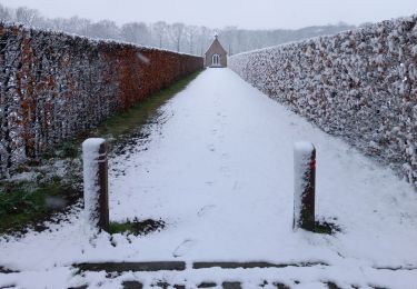
Randonnée Marche de 10,4 km à découvrir à Flandre, Anvers, Malle. Cette randonnée est proposée par PhilippeWinant.
Description
Bollekepijl verkrijgbaar op website toerisme Malle
https://www.toerisme-malle.be/wandelen-fietsen/wandelen/uitgestippelde-wandelingen/tichelgatpad
Localisation
Pays :
Belgique
Région :
Flandre
Département/Province :
Anvers
Commune :
Malle
Localité :
Westmalle
Départ:(Dec)
Départ:(UTM)
617646 ; 5685217 (31U) N.
Commentaires
Randonnées à proximité
![Randonnée Marche Zoersel - Promenade en boucle Zoersel Westmalle - Photo](https://media.geolcdn.com/t/375/260/7d9b83b6-a342-40a4-aedb-6f0f256c43a9.jpg&format=jpg&maxdim=2)
![Marche Marche](https://static1.geolcdn.com/sitytour/trail-icons/101.png)
Promenade en boucle Zoersel Westmalle
Marche
Très difficile
Zoersel,
Flandre,
Anvers,
Belgique
![](/images/other/stat-length.png)
24 km | 26 km-effort
5h 46min
![](https://static1.geolcdn.com/siteimages/upload/files/16400158638029165_repeat_loop_refresh_sync_direction_icon.png)
Oui
![Randonnée Vélo Malle - Belgie - Trappistenroute - Photo](https://media.geolcdn.com/t/375/260/ext.jpg?maxdim=2&url=https%3A%2F%2Fstatic1.geolcdn.com%2Fsiteimages%2Fupload%2Ffiles%2F1524743154velo.jpg)
![Vélo Vélo](https://static1.geolcdn.com/sitytour/trail-icons/200.png)
Belgie - Trappistenroute
Vélo
Très facile
(1)
Malle,
Flandre,
Anvers,
Belgique
![](/images/other/stat-length.png)
42 km | 46 km-effort
Inconnu
![](https://static1.geolcdn.com/siteimages/upload/files/16400158638029165_repeat_loop_refresh_sync_direction_icon.png)
Non
![Randonnée Marche Zoersel - w-belgie-rond-zoersel-langs-boshuisje-en-salphen - Photo](https://media.geolcdn.com/t/375/260/ext.jpg?maxdim=2&url=https%3A%2F%2Fstatic1.geolcdn.com%2Fsiteimages%2Fupload%2Ffiles%2F1553511878bg_sport_marche.png)
![Marche Marche](https://static1.geolcdn.com/sitytour/trail-icons/101.png)
w-belgie-rond-zoersel-langs-boshuisje-en-salphen
Marche
Très facile
Zoersel,
Flandre,
Anvers,
Belgique
![](/images/other/stat-length.png)
17,8 km | 19,6 km-effort
Inconnu
![](https://static1.geolcdn.com/siteimages/upload/files/16400158638029165_repeat_loop_refresh_sync_direction_icon.png)
Oui
![Randonnée Marche Zoersel - Belgie - wandling St. Antonius Zoersel - Photo](https://media.geolcdn.com/t/375/260/ext.jpg?maxdim=2&url=https%3A%2F%2Fstatic1.geolcdn.com%2Fsiteimages%2Fupload%2Ffiles%2F1553511878bg_sport_marche.png)
![Marche Marche](https://static1.geolcdn.com/sitytour/trail-icons/101.png)
Belgie - wandling St. Antonius Zoersel
Marche
Très facile
Zoersel,
Flandre,
Anvers,
Belgique
![](/images/other/stat-length.png)
11,4 km | 12,4 km-effort
Inconnu
![](https://static1.geolcdn.com/siteimages/upload/files/16400158638029165_repeat_loop_refresh_sync_direction_icon.png)
Oui
![Randonnée Marche Malle - Belgie - Wandeling Westmalle - Photo](https://media.geolcdn.com/t/375/260/ext.jpg?maxdim=2&url=https%3A%2F%2Fstatic1.geolcdn.com%2Fsiteimages%2Fupload%2Ffiles%2F1553511878bg_sport_marche.png)
![Marche Marche](https://static1.geolcdn.com/sitytour/trail-icons/101.png)
Belgie - Wandeling Westmalle
Marche
Très facile
Malle,
Flandre,
Anvers,
Belgique
![](/images/other/stat-length.png)
13,5 km | 14,6 km-effort
Inconnu
![](https://static1.geolcdn.com/siteimages/upload/files/16400158638029165_repeat_loop_refresh_sync_direction_icon.png)
Oui
![Randonnée Marche Malle - Belgie - GR Kempen 1 - Photo](https://media.geolcdn.com/t/375/260/ext.jpg?maxdim=2&url=https%3A%2F%2Fstatic1.geolcdn.com%2Fsiteimages%2Fupload%2Ffiles%2F1553511878bg_sport_marche.png)
![Marche Marche](https://static1.geolcdn.com/sitytour/trail-icons/101.png)
Belgie - GR Kempen 1
Marche
Très facile
Malle,
Flandre,
Anvers,
Belgique
![](/images/other/stat-length.png)
26 km | 27 km-effort
Inconnu
![](https://static1.geolcdn.com/siteimages/upload/files/16400158638029165_repeat_loop_refresh_sync_direction_icon.png)
Non
![Randonnée Marche Zoersel - Zoersel Legendenwandeling - 11 km RT - Photo](https://media.geolcdn.com/t/375/260/ext.jpg?maxdim=2&url=https%3A%2F%2Fstatic1.geolcdn.com%2Fsiteimages%2Fupload%2Ffiles%2F1553511878bg_sport_marche.png)
![Marche Marche](https://static1.geolcdn.com/sitytour/trail-icons/101.png)
Zoersel Legendenwandeling - 11 km RT
Marche
Très facile
Zoersel,
Flandre,
Anvers,
Belgique
![](/images/other/stat-length.png)
11,2 km | 12 km-effort
Inconnu
![](https://static1.geolcdn.com/siteimages/upload/files/16400158638029165_repeat_loop_refresh_sync_direction_icon.png)
Oui
![Randonnée Marche Brecht - Winterwandeling_Brecht - Photo](https://media.geolcdn.com/t/375/260/ext.jpg?maxdim=2&url=https%3A%2F%2Fstatic1.geolcdn.com%2Fsiteimages%2Fupload%2Ffiles%2F1553511878bg_sport_marche.png)
![Marche Marche](https://static1.geolcdn.com/sitytour/trail-icons/101.png)
Winterwandeling_Brecht
Marche
Très facile
Brecht,
Flandre,
Anvers,
Belgique
![](/images/other/stat-length.png)
12,2 km | 13,1 km-effort
Inconnu
![](https://static1.geolcdn.com/siteimages/upload/files/16400158638029165_repeat_loop_refresh_sync_direction_icon.png)
Non
![Randonnée Marche Malle - Westmalle Renesse-Salphen - 9 km RT - Photo](https://media.geolcdn.com/t/375/260/ext.jpg?maxdim=2&url=https%3A%2F%2Fstatic1.geolcdn.com%2Fsiteimages%2Fupload%2Ffiles%2F1553511878bg_sport_marche.png)
![Marche Marche](https://static1.geolcdn.com/sitytour/trail-icons/101.png)
Westmalle Renesse-Salphen - 9 km RT
Marche
Très facile
Malle,
Flandre,
Anvers,
Belgique
![](/images/other/stat-length.png)
9,3 km | 10,2 km-effort
Inconnu
![](https://static1.geolcdn.com/siteimages/upload/files/16400158638029165_repeat_loop_refresh_sync_direction_icon.png)
Oui