![](/images/other/stat-length.png)
![Randonnée Marche Anhée - Bioul boucle 10 km - Photo](https://media.geolcdn.com/t/1900/400/ext.pjpeg?maxdim=2&url=https%3A%2F%2Fstatic1.geolcdn.com%2Fsiteimages%2Fupload%2Ffiles%2F1553511878bg_sport_marche.png)
Bioul boucle 10 km
pinkwater76
Utilisateur
![Longueur](/images/other/stat-length.png)
Longueur
9,9 km
![Altitude max](https://static1.geolcdn.com/siteimages/upload/files/1508320355ic_sort_altitude_max_24dp.png)
Altitude max
251 m
![Dénivelé positif](https://static1.geolcdn.com/siteimages/upload/files/1508320355ic_sort_den_pos_24dp.png)
Dénivelé positif
160 m
![Km-Effort](/images/other/stat-length.png)
Km-Effort
12,1 km
![Altitude min](https://static1.geolcdn.com/siteimages/upload/files/1508320355ic_sort_altitude_min_24dp.png)
Altitude min
174 m
![Dénivelé négatif](https://static1.geolcdn.com/siteimages/upload/files/1508320355ic_sort_den_neg_24dp.png)
Dénivelé négatif
162 m
![Boucle](https://static1.geolcdn.com/siteimages/upload/files/16400158638029165_repeat_loop_refresh_sync_direction_icon.png)
Boucle
Oui
Date de création :
2020-12-20 09:01:53.702
Dernière modification :
2020-12-20 11:36:27.505
![Marche](https://static1.geolcdn.com/sitytour/trail-icons/101.png)
2h31
Difficulté : Très facile
![Scannez ce code QR pour ouvrir la randonnée dans l'application SityTrail](https://capi.geolives.com/qq0zvz2zws4bq2lad0pu/sitytour/trails/2622611/qr.png?size=200)
Application GPS de randonnée GRATUITE
À propos
Randonnée Marche de 9,9 km à découvrir à Wallonie, Namur, Anhée. Cette randonnée est proposée par pinkwater76.
Description
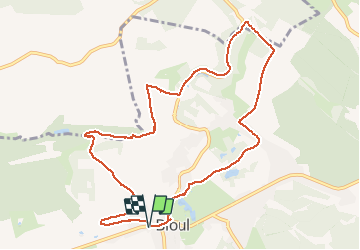
Boucle de 10 km au départ de village de Bioul.
Beaucoup trop d'asphalte à mon goût mais balade néanmoins assez agréable grâce aux paysages campagnards des environs.
NPR
Localisation
Pays :
Belgique
Région :
Wallonie
Département/Province :
Namur
Commune :
Anhée
Localité :
Bioul
Départ:(Dec)
Départ:(UTM)
627643 ; 5577225 (31U) N.
Commentaires
Randonnées à proximité
![Randonnée Marche Anhée - RB-Na-22_Bioul_via-racc - Photo](https://media.geolcdn.com/t/375/260/9e39c4d6-ac1b-4acf-9686-7baae428f1a0.jpg&format=jpg&maxdim=2)
![Marche Marche](https://static1.geolcdn.com/sitytour/trail-icons/101.png)
RB-Na-22_Bioul_via-racc
Marche
Très difficile
(6)
Anhée,
Wallonie,
Namur,
Belgique
![](/images/other/stat-length.png)
16,7 km | 21 km-effort
4h 52min
![](https://static1.geolcdn.com/siteimages/upload/files/16400158638029165_repeat_loop_refresh_sync_direction_icon.png)
Oui
![Randonnée Marche Anhée - RB-Na-22_Bioul - Photo](https://media.geolcdn.com/t/375/260/8622883f-03f3-4eff-8458-0cb9f1aba19e.jpg&format=jpg&maxdim=2)
![Marche Marche](https://static1.geolcdn.com/sitytour/trail-icons/101.png)
RB-Na-22_Bioul
Marche
Très difficile
(11)
Anhée,
Wallonie,
Namur,
Belgique
![](/images/other/stat-length.png)
19,5 km | 25 km-effort
5h 46min
![](https://static1.geolcdn.com/siteimages/upload/files/16400158638029165_repeat_loop_refresh_sync_direction_icon.png)
Oui
![Randonnée Marche Anhée - RB-Na-16_Maredsous - Photo](https://media.geolcdn.com/t/375/260/ext.jpg?maxdim=2&url=https%3A%2F%2Fservices.sitytrail.com%2FGeolivesWS%2FDownloadMedia.ashx%3FTrailID%3D252846%26Media%3D757ed732-5926-4a49-9c27-a2a6c3abf11c.jpg)
![Marche Marche](https://static1.geolcdn.com/sitytour/trail-icons/101.png)
RB-Na-16_Maredsous
Marche
Moyen
(20)
Anhée,
Wallonie,
Namur,
Belgique
![](/images/other/stat-length.png)
18,3 km | 24 km-effort
5h 13min
![](https://static1.geolcdn.com/siteimages/upload/files/16400158638029165_repeat_loop_refresh_sync_direction_icon.png)
Oui
![Randonnée Marche Anhée - RF-Na-05 Annevoie, côté Jardins_Grande-boucle - Photo](https://media.geolcdn.com/t/375/260/ext.jpg?maxdim=2&url=https%3A%2F%2Fservices.sitytrail.com%2FGeolivesWS%2FDownloadMedia.ashx%3FTrailID%3D545753%26Media%3D5d973c83-4a6c-40fc-a026-25de6c754887.JPG)
![Marche Marche](https://static1.geolcdn.com/sitytour/trail-icons/101.png)
RF-Na-05 Annevoie, côté Jardins_Grande-boucle
Marche
Moyen
(11)
Anhée,
Wallonie,
Namur,
Belgique
![](/images/other/stat-length.png)
11,3 km | 14,5 km-effort
3h 6min
![](https://static1.geolcdn.com/siteimages/upload/files/16400158638029165_repeat_loop_refresh_sync_direction_icon.png)
Oui
![Randonnée Marche Anhée - RF-Na-05 Annevoie, côté Jardins_Petite-boucle - Photo](https://media.geolcdn.com/t/375/260/ext.jpg?maxdim=2&url=https%3A%2F%2Fservices.sitytrail.com%2FGeolivesWS%2FDownloadMedia.ashx%3FTrailID%3D545751%26Media%3D5d973c83-4a6c-40fc-a026-25de6c754887.JPG)
![Marche Marche](https://static1.geolcdn.com/sitytour/trail-icons/101.png)
RF-Na-05 Annevoie, côté Jardins_Petite-boucle
Marche
Facile
(7)
Anhée,
Wallonie,
Namur,
Belgique
![](/images/other/stat-length.png)
7,4 km | 10 km-effort
2h 7min
![](https://static1.geolcdn.com/siteimages/upload/files/16400158638029165_repeat_loop_refresh_sync_direction_icon.png)
Oui
![Randonnée Marche Anhée - RB-Na-16_Maredsous_via-racc - Photo](https://media.geolcdn.com/t/375/260/ext.jpg?maxdim=2&url=https%3A%2F%2Fstatic1.geolcdn.com%2Fsiteimages%2Fupload%2Ffiles%2F1553511878bg_sport_marche.png)
![Marche Marche](https://static1.geolcdn.com/sitytour/trail-icons/101.png)
RB-Na-16_Maredsous_via-racc
Marche
Facile
(17)
Anhée,
Wallonie,
Namur,
Belgique
![](/images/other/stat-length.png)
13 km | 16,6 km-effort
3h 40min
![](https://static1.geolcdn.com/siteimages/upload/files/16400158638029165_repeat_loop_refresh_sync_direction_icon.png)
Oui
![Randonnée Marche Anhée - Balade de l'abbaye de Maredsous à Ermeton-sur-Biert - Photo](https://media.geolcdn.com/t/375/260/ext.jpg?maxdim=2&url=https%3A%2F%2Fservices.sitytrail.com%2FGeolivesWS%2FDownloadMedia.ashx%3FTrailID%3D1068875%26Media%3D20181106140411.jpg)
![Marche Marche](https://static1.geolcdn.com/sitytour/trail-icons/101.png)
Balade de l'abbaye de Maredsous à Ermeton-sur-Biert
Marche
Facile
(4)
Anhée,
Wallonie,
Namur,
Belgique
![](/images/other/stat-length.png)
9,2 km | 11,9 km-effort
2h 32min
![](https://static1.geolcdn.com/siteimages/upload/files/16400158638029165_repeat_loop_refresh_sync_direction_icon.png)
Oui
![Marche Marche](https://static1.geolcdn.com/sitytour/trail-icons/101.png)
Sosoye - Circuit Natura 2000, des sites qui valent le détour - Na11
Marche
Moyen
(6)
Anhée,
Wallonie,
Namur,
Belgique
![](/images/other/stat-length.png)
4,9 km | 6,3 km-effort
1h 21min
![](https://static1.geolcdn.com/siteimages/upload/files/16400158638029165_repeat_loop_refresh_sync_direction_icon.png)
Oui
![Randonnée Marche Anhée - Balade à Denée - Photo](https://media.geolcdn.com/t/375/260/ext.jpg?maxdim=2&url=https%3A%2F%2Fservices.sitytrail.com%2FGeolivesWS%2FDownloadMedia.ashx%3FTrailID%3D274406%26Media%3Dfced633a-60e9-42df-93a1-c2f30963bb68.JPG)
![Marche Marche](https://static1.geolcdn.com/sitytour/trail-icons/101.png)
Balade à Denée
Marche
Très facile
(1)
Anhée,
Wallonie,
Namur,
Belgique
![](/images/other/stat-length.png)
5,8 km | 7,4 km-effort
1h 35min
![](https://static1.geolcdn.com/siteimages/upload/files/16400158638029165_repeat_loop_refresh_sync_direction_icon.png)
Oui