![](/images/other/stat-length.png)
![Randonnée Marche Bad Neuenahr-Ahrweiler - Ahrsteig etappe 6 Rondwandeling 36km. - Photo](https://media.geolcdn.com/t/1900/400/ext.pjpeg?maxdim=2&url=https%3A%2F%2Fstatic1.geolcdn.com%2Fsiteimages%2Fupload%2Ffiles%2F1553511878bg_sport_marche.png)
Ahrsteig etappe 6 Rondwandeling 36km.
flip96
Utilisateur
![Longueur](/images/other/stat-length.png)
Longueur
35 km
![Altitude max](https://static1.geolcdn.com/siteimages/upload/files/1508320355ic_sort_altitude_max_24dp.png)
Altitude max
336 m
![Dénivelé positif](https://static1.geolcdn.com/siteimages/upload/files/1508320355ic_sort_den_pos_24dp.png)
Dénivelé positif
1039 m
![Km-Effort](/images/other/stat-length.png)
Km-Effort
49 km
![Altitude min](https://static1.geolcdn.com/siteimages/upload/files/1508320355ic_sort_altitude_min_24dp.png)
Altitude min
81 m
![Dénivelé négatif](https://static1.geolcdn.com/siteimages/upload/files/1508320355ic_sort_den_neg_24dp.png)
Dénivelé négatif
1048 m
![Boucle](https://static1.geolcdn.com/siteimages/upload/files/16400158638029165_repeat_loop_refresh_sync_direction_icon.png)
Boucle
Oui
Date de création :
2014-12-10 00:00:00.0
Dernière modification :
2014-12-10 00:00:00.0
![Marche](https://static1.geolcdn.com/sitytour/trail-icons/101.png)
10h18
Difficulté : Difficile
![Scannez ce code QR pour ouvrir la randonnée dans l'application SityTrail](https://capi.geolives.com/qq0zvz2zws4bq2lad0pu/sitytour/trails/262235/qr.png?size=200)
Application GPS de randonnée GRATUITE
À propos
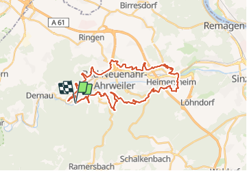
Randonnée Marche de 35 km à découvrir à Rhénanie-Palatinat, Landkreis Ahrweiler, Bad Neuenahr-Ahrweiler. Cette randonnée est proposée par flip96.
Description
Ahrsteig etappe 6 Rondwandeling.
Naar Heimersheim via Ahrsteig 6 en een stukje van etappe 7.
Via de Rotweinwanderweg terug naar Walporzheim.
Fraaie, pittige route.
Opmerkingen? flip96@home.nl
Localisation
Pays :
Allemagne
Région :
Rhénanie-Palatinat
Département/Province :
Landkreis Ahrweiler
Commune :
Bad Neuenahr-Ahrweiler
Localité :
Unknown
Départ:(Dec)
Départ:(UTM)
363936 ; 5599214 (32U) N.
Commentaires
Randonnées à proximité
![Randonnée A pied Mayschoß - Mayschoß - Rundweg 3 - Photo](https://media.geolcdn.com/t/375/260/ext.jpg?maxdim=2&url=https%3A%2F%2Fmedia.geolcdn.com%2Ff%2F16f600b5-0607-441e-b639-8cbd6e404fe6.jpeg)
![A pied A pied](https://static1.geolcdn.com/sitytour/trail-icons/100.png)
Mayschoß - Rundweg 3
A pied
Facile
Mayschoß,
Rhénanie-Palatinat,
Landkreis Ahrweiler,
Allemagne
![](/images/other/stat-length.png)
7,2 km | 11,9 km-effort
2h 41min
![](https://static1.geolcdn.com/siteimages/upload/files/16400158638029165_repeat_loop_refresh_sync_direction_icon.png)
Oui
![Randonnée A pied Mayschoß - Mayschoß - Rundweg 2 - Photo](https://media.geolcdn.com/t/375/260/ext.jpg?maxdim=2&url=https%3A%2F%2Fmedia.geolcdn.com%2Ff%2F16f600b5-0607-441e-b639-8cbd6e404fe6.jpeg)
![A pied A pied](https://static1.geolcdn.com/sitytour/trail-icons/100.png)
Mayschoß - Rundweg 2
A pied
Facile
Mayschoß,
Rhénanie-Palatinat,
Landkreis Ahrweiler,
Allemagne
![](/images/other/stat-length.png)
5,8 km | 9,8 km-effort
2h 13min
![](https://static1.geolcdn.com/siteimages/upload/files/16400158638029165_repeat_loop_refresh_sync_direction_icon.png)
Oui
![Randonnée A pied Mayschoß - Mayschoß - Rundweg 1 - Photo](https://media.geolcdn.com/t/375/260/ext.jpg?maxdim=2&url=https%3A%2F%2Fmedia.geolcdn.com%2Ff%2F16f600b5-0607-441e-b639-8cbd6e404fe6.jpeg)
![A pied A pied](https://static1.geolcdn.com/sitytour/trail-icons/100.png)
Mayschoß - Rundweg 1
A pied
Facile
Mayschoß,
Rhénanie-Palatinat,
Landkreis Ahrweiler,
Allemagne
![](/images/other/stat-length.png)
3,8 km | 6,2 km-effort
1h 24min
![](https://static1.geolcdn.com/siteimages/upload/files/16400158638029165_repeat_loop_refresh_sync_direction_icon.png)
Oui
![Randonnée A pied Bad Neuenahr-Ahrweiler - Eisenweg - Photo](https://media.geolcdn.com/t/375/260/ext.jpg?maxdim=2&url=https%3A%2F%2Fmedia.geolcdn.com%2Ff%2Ffb3543ed-099d-4e89-a581-5255ebeb06e2.jpeg)
![A pied A pied](https://static1.geolcdn.com/sitytour/trail-icons/100.png)
Eisenweg
A pied
Facile
Bad Neuenahr-Ahrweiler,
Rhénanie-Palatinat,
Landkreis Ahrweiler,
Allemagne
![](/images/other/stat-length.png)
10,3 km | 13,9 km-effort
3h 9min
![](https://static1.geolcdn.com/siteimages/upload/files/16400158638029165_repeat_loop_refresh_sync_direction_icon.png)
Oui
![Randonnée A pied Bad Neuenahr-Ahrweiler - Weinbaulehrpfad - Photo](https://media.geolcdn.com/t/375/260/ext.jpg?maxdim=2&url=https%3A%2F%2Fstatic1.geolcdn.com%2Fsiteimages%2Fupload%2Ffiles%2F1545311037marcheuse_200dpi.jpg)
![A pied A pied](https://static1.geolcdn.com/sitytour/trail-icons/100.png)
Weinbaulehrpfad
A pied
Facile
Bad Neuenahr-Ahrweiler,
Rhénanie-Palatinat,
Landkreis Ahrweiler,
Allemagne
![](/images/other/stat-length.png)
6,7 km | 8,9 km-effort
2h 1min
![](https://static1.geolcdn.com/siteimages/upload/files/16400158638029165_repeat_loop_refresh_sync_direction_icon.png)
Oui
![Randonnée Vélo Bad Neuenahr-Ahrweiler - f-duitsland-oostelijke-vulkaaneifel - Photo](https://media.geolcdn.com/t/375/260/ext.jpg?maxdim=2&url=https%3A%2F%2Fstatic1.geolcdn.com%2Fsiteimages%2Fupload%2Ffiles%2F1524743154velo.jpg)
![Vélo Vélo](https://static1.geolcdn.com/sitytour/trail-icons/200.png)
f-duitsland-oostelijke-vulkaaneifel
Vélo
Très facile
Bad Neuenahr-Ahrweiler,
Rhénanie-Palatinat,
Landkreis Ahrweiler,
Allemagne
![](/images/other/stat-length.png)
96 km | 125 km-effort
Inconnu
![](https://static1.geolcdn.com/siteimages/upload/files/16400158638029165_repeat_loop_refresh_sync_direction_icon.png)
Oui
![Randonnée Marche Bad Neuenahr-Ahrweiler - Ahrsteig Etappe 5 Rondwandeling 36km. - Photo](https://media.geolcdn.com/t/375/260/ext.jpg?maxdim=2&url=https%3A%2F%2Fstatic1.geolcdn.com%2Fsiteimages%2Fupload%2Ffiles%2F1553511878bg_sport_marche.png)
![Marche Marche](https://static1.geolcdn.com/sitytour/trail-icons/101.png)
Ahrsteig Etappe 5 Rondwandeling 36km.
Marche
Difficile
Bad Neuenahr-Ahrweiler,
Rhénanie-Palatinat,
Landkreis Ahrweiler,
Allemagne
![](/images/other/stat-length.png)
35 km | 47 km-effort
10h 12min
![](https://static1.geolcdn.com/siteimages/upload/files/16400158638029165_repeat_loop_refresh_sync_direction_icon.png)
Oui