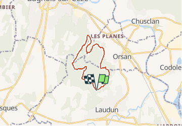
![](/images/other/stat-length.png)
![Randonnée Trail Laudun-l'Ardoise - Trail dent de Signac - Photo](https://media.geolcdn.com/t/1900/400/ext.pjpeg?maxdim=2&url=https%3A%2F%2Fstatic1.geolcdn.com%2Fsiteimages%2Fupload%2Ffiles%2F1524743154running.jpg)
Trail dent de Signac
florun30290
Utilisateur
![Longueur](/images/other/stat-length.png)
![Altitude max](https://static1.geolcdn.com/siteimages/upload/files/1508320355ic_sort_altitude_max_24dp.png)
![Dénivelé positif](https://static1.geolcdn.com/siteimages/upload/files/1508320355ic_sort_den_pos_24dp.png)
![Km-Effort](/images/other/stat-length.png)
![Altitude min](https://static1.geolcdn.com/siteimages/upload/files/1508320355ic_sort_altitude_min_24dp.png)
![Dénivelé négatif](https://static1.geolcdn.com/siteimages/upload/files/1508320355ic_sort_den_neg_24dp.png)
![Boucle](https://static1.geolcdn.com/siteimages/upload/files/16400158638029165_repeat_loop_refresh_sync_direction_icon.png)
![Trail](https://static1.geolcdn.com/sitytour/trail-icons/104.png)
--
Difficulté : Moyen
![Scannez ce code QR pour ouvrir la randonnée dans l'application SityTrail](https://capi.geolives.com/qq0zvz2zws4bq2lad0pu/sitytour/trails/2618864/qr.png?size=200)
Application GPS de randonnée GRATUITE
À propos
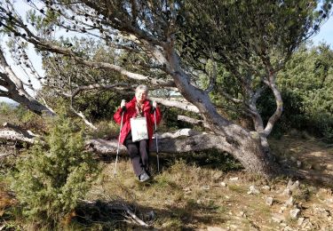
Randonnée Trail de 10,4 km à découvrir à Occitanie, Gard, Laudun-l'Ardoise. Cette randonnée est proposée par florun30290.
Description
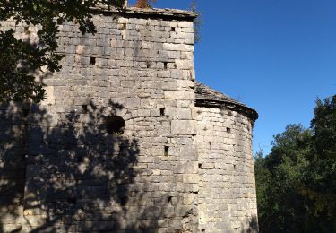
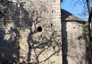
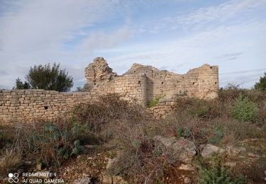
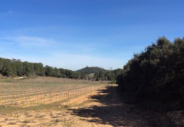
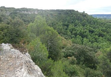
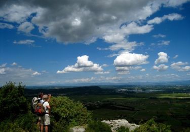
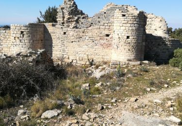
Départ du parking du camp de César en longeant le DFCI menant à Orsan sur 1.8km . Suivre le DFCI . APrès 500m de montée , au virage où il y a une stèle, prendre le monotrace à droite qui mène vers la dent de signac. Après 900m prendre le monotrace de gauche pour monter à la dent de Signac (500 m de montée difficile sur la fin). En haut monotrace longeant la falaise (beau point de vue sur le mont-ventoux. A l'intersection du DFCI prendre à gauche pour aller vers la citerne. Le retour se fait sur un monotrace.
Localisation
Commentaires
Randonnées à proximité
![Randonnée Marche Laudun-l'Ardoise - 30 camp de cesar - Photo](https://media.geolcdn.com/t/375/260/3a336c68-96d1-47ed-8893-44d2a09973df.jpg&format=jpg&maxdim=2)
![Marche Marche](https://static1.geolcdn.com/sitytour/trail-icons/101.png)
Marche
![](/images/other/stat-length.png)
![](https://static1.geolcdn.com/siteimages/upload/files/16400158638029165_repeat_loop_refresh_sync_direction_icon.png)
![Randonnée Marche Laudun-l'Ardoise - Camp de César - Photo](https://media.geolcdn.com/t/375/260/d5a384ff-a456-4015-9a11-54cd89317120.jpg&format=jpg&maxdim=2)
![Marche Marche](https://static1.geolcdn.com/sitytour/trail-icons/101.png)
Marche
![](/images/other/stat-length.png)
![](https://static1.geolcdn.com/siteimages/upload/files/16400158638029165_repeat_loop_refresh_sync_direction_icon.png)
![Randonnée Marche Laudun-l'Ardoise - 30 camp de César 12/07/23 - Photo](https://media.geolcdn.com/t/375/260/b6923c2c-a6f4-44eb-961e-2efc9564941a.jpg&format=jpg&maxdim=2)
![Marche Marche](https://static1.geolcdn.com/sitytour/trail-icons/101.png)
Marche
![](/images/other/stat-length.png)
![](https://static1.geolcdn.com/siteimages/upload/files/16400158638029165_repeat_loop_refresh_sync_direction_icon.png)
![Randonnée Marche Chusclan - PF-Chusclan - Dent de Marcoule et Château de Gicon - Photo](https://media.geolcdn.com/t/375/260/f10873c5-07cb-49fe-9595-b037cf2e17a6.jpg&format=jpg&maxdim=2)
![Marche Marche](https://static1.geolcdn.com/sitytour/trail-icons/101.png)
Marche
![](/images/other/stat-length.png)
![](https://static1.geolcdn.com/siteimages/upload/files/16400158638029165_repeat_loop_refresh_sync_direction_icon.png)
![Randonnée V.T.T. Bagnols-sur-Cèze - Rando VTT du plateau de Lacau 35km - Photo](https://media.geolcdn.com/t/375/260/ext.jpg?maxdim=2&url=https%3A%2F%2Fservices.sitytrail.com%2FGeolivesWS%2FDownloadMedia.ashx%3FTrailID%3D632644%26Media%3Dfix__20160918110742.jpg)
![V.T.T. V.T.T.](https://static1.geolcdn.com/sitytour/trail-icons/202.png)
V.T.T.
![](/images/other/stat-length.png)
![](https://static1.geolcdn.com/siteimages/upload/files/16400158638029165_repeat_loop_refresh_sync_direction_icon.png)
![Randonnée Marche Orsan - Chapelle St Pierre - Photo](https://media.geolcdn.com/t/375/260/ext.jpg?maxdim=2&url=https%3A%2F%2Fstatic1.geolcdn.com%2Fsiteimages%2Fupload%2Ffiles%2F1553511878bg_sport_marche.png)
![Marche Marche](https://static1.geolcdn.com/sitytour/trail-icons/101.png)
Marche
![](/images/other/stat-length.png)
![](https://static1.geolcdn.com/siteimages/upload/files/16400158638029165_repeat_loop_refresh_sync_direction_icon.png)
![Randonnée Marche Orsan - Orsan - Chapelle de St Jean de Castres - Photo](https://media.geolcdn.com/t/375/260/ext.jpg?maxdim=2&url=https%3A%2F%2Fservices.sitytrail.com%2FGeolivesWS%2FDownloadMedia.ashx%3FTrailID%3D105314%26Media%3D9005_4.jpg)
![Marche Marche](https://static1.geolcdn.com/sitytour/trail-icons/101.png)
Marche
![](/images/other/stat-length.png)
![](https://static1.geolcdn.com/siteimages/upload/files/16400158638029165_repeat_loop_refresh_sync_direction_icon.png)
![Randonnée Marche Orsan - Orsan - Photo](https://media.geolcdn.com/t/375/260/4eb1248d-2eba-4484-ab8d-a608b5d56ba5.jpg&format=jpg&maxdim=2)
![Marche Marche](https://static1.geolcdn.com/sitytour/trail-icons/101.png)
![Randonnée Marche Laudun-l'Ardoise - Camp César 1 - Photo](https://media.geolcdn.com/t/375/260/c5bd3f62-f30a-42fe-a946-ba9608c8e44c.jpg&format=jpg&maxdim=2)
![Marche Marche](https://static1.geolcdn.com/sitytour/trail-icons/101.png)
Marche
![](/images/other/stat-length.png)
![](https://static1.geolcdn.com/siteimages/upload/files/16400158638029165_repeat_loop_refresh_sync_direction_icon.png)