![](/images/other/stat-length.png)
![Randonnée Marche nordique Châteaudun - Marche_Chateaudun_20140326 - Photo](https://media.geolcdn.com/t/1900/400/ext.pjpeg?maxdim=2&url=https%3A%2F%2Fstatic1.geolcdn.com%2Fsiteimages%2Fupload%2Ffiles%2F1545311037marcheuse_200dpi.jpg)
Marche_Chateaudun_20140326
chlafaille
Utilisateur
![Longueur](/images/other/stat-length.png)
Longueur
21 km
![Altitude max](https://static1.geolcdn.com/siteimages/upload/files/1508320355ic_sort_altitude_max_24dp.png)
Altitude max
154 m
![Dénivelé positif](https://static1.geolcdn.com/siteimages/upload/files/1508320355ic_sort_den_pos_24dp.png)
Dénivelé positif
254 m
![Km-Effort](/images/other/stat-length.png)
Km-Effort
24 km
![Altitude min](https://static1.geolcdn.com/siteimages/upload/files/1508320355ic_sort_altitude_min_24dp.png)
Altitude min
105 m
![Dénivelé négatif](https://static1.geolcdn.com/siteimages/upload/files/1508320355ic_sort_den_neg_24dp.png)
Dénivelé négatif
256 m
![Boucle](https://static1.geolcdn.com/siteimages/upload/files/16400158638029165_repeat_loop_refresh_sync_direction_icon.png)
Boucle
Oui
Date de création :
2014-12-10 00:00:00.0
Dernière modification :
2014-12-10 00:00:00.0
![Marche nordique](https://static1.geolcdn.com/sitytour/trail-icons/102.png)
3h42
Difficulté : Difficile
![Scannez ce code QR pour ouvrir la randonnée dans l'application SityTrail](https://capi.geolives.com/qq0zvz2zws4bq2lad0pu/sitytour/trails/260670/qr.png?size=200)
Application GPS de randonnée GRATUITE
À propos
Randonnée Marche nordique de 21 km à découvrir à Centre-Val de Loire, Eure-et-Loir, Châteaudun. Cette randonnée est proposée par chlafaille.
Description
INFORMATION: mon GPS s'est "désaligné" sur la portion Est de mon parcours (entre "le Moulin à Tan" et "Le Croc Marbot")... il faut bien suivre le GR35 sur cette partie.
Localisation
Pays :
France
Région :
Centre-Val de Loire
Département/Province :
Eure-et-Loir
Commune :
Châteaudun
Localité :
Unknown
Départ:(Dec)
Départ:(UTM)
375707 ; 5325067 (31U) N.
Commentaires
Randonnées à proximité
![Randonnée Marche Châteaudun - Châteaudun - Marboué - Photo](https://media.geolcdn.com/t/375/260/6fc7324d-3026-46fa-8ba5-43d23d854789.jpg&format=jpg&maxdim=2)
![Marche Marche](https://static1.geolcdn.com/sitytour/trail-icons/101.png)
Châteaudun - Marboué
Marche
Moyen
Châteaudun,
Centre-Val de Loire,
Eure-et-Loir,
France
![](/images/other/stat-length.png)
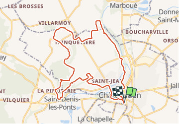
19,2 km | 22 km-effort
6h 25min
![](https://static1.geolcdn.com/siteimages/upload/files/16400158638029165_repeat_loop_refresh_sync_direction_icon.png)
Oui
![Randonnée V.T.T. Châteaudun - Le moulin de Courgain - Châteaudin - Photo](https://media.geolcdn.com/t/375/260/ext.jpg?maxdim=2&url=https%3A%2F%2Fservices.sitytrail.com%2FGeolivesWS%2FDownloadMedia.ashx%3FTrailID%3D215150%26Media%3D15745_2.jpg)
![V.T.T. V.T.T.](https://static1.geolcdn.com/sitytour/trail-icons/202.png)
Le moulin de Courgain - Châteaudin
V.T.T.
Difficile
Châteaudun,
Centre-Val de Loire,
Eure-et-Loir,
France
![](/images/other/stat-length.png)
33 km | 39 km-effort
1h 49min
![](https://static1.geolcdn.com/siteimages/upload/files/16400158638029165_repeat_loop_refresh_sync_direction_icon.png)
Oui
![Randonnée Marche Châteaudun - Châteaudun 1 - Photo](https://media.geolcdn.com/t/375/260/ext.jpg?maxdim=2&url=https%3A%2F%2Fstatic1.geolcdn.com%2Fsiteimages%2Fupload%2Ffiles%2F1553511878bg_sport_marche.png)
![Marche Marche](https://static1.geolcdn.com/sitytour/trail-icons/101.png)
Châteaudun 1
Marche
Moyen
Châteaudun,
Centre-Val de Loire,
Eure-et-Loir,
France
![](/images/other/stat-length.png)
9 km | 10,2 km-effort
2h 46min
![](https://static1.geolcdn.com/siteimages/upload/files/16400158638029165_repeat_loop_refresh_sync_direction_icon.png)
Oui
![Randonnée A pied Cloyes-les-Trois-Rivières - Douy PC27sept2020 - Photo](https://media.geolcdn.com/t/375/260/ext.jpg?maxdim=2&url=https%3A%2F%2Fstatic1.geolcdn.com%2Fsiteimages%2Fupload%2Ffiles%2F1545311037marcheuse_200dpi.jpg)
![A pied A pied](https://static1.geolcdn.com/sitytour/trail-icons/100.png)
Douy PC27sept2020
A pied
Moyen
Cloyes-les-Trois-Rivières,
Centre-Val de Loire,
Eure-et-Loir,
France
![](/images/other/stat-length.png)
11,3 km | 13 km-effort
Inconnu
![](https://static1.geolcdn.com/siteimages/upload/files/16400158638029165_repeat_loop_refresh_sync_direction_icon.png)
Oui
![Randonnée A pied Châteaudun - Châteaudun PC25sept2020 - Photo](https://media.geolcdn.com/t/375/260/ext.jpg?maxdim=2&url=https%3A%2F%2Fstatic1.geolcdn.com%2Fsiteimages%2Fupload%2Ffiles%2F1545311037marcheuse_200dpi.jpg)
![A pied A pied](https://static1.geolcdn.com/sitytour/trail-icons/100.png)
Châteaudun PC25sept2020
A pied
Moyen
Châteaudun,
Centre-Val de Loire,
Eure-et-Loir,
France
![](/images/other/stat-length.png)
9,6 km | 11,1 km-effort
Inconnu
![](https://static1.geolcdn.com/siteimages/upload/files/16400158638029165_repeat_loop_refresh_sync_direction_icon.png)
Oui
![Randonnée V.T.T. Châteaudun - Le moulin de Courgain - Chateaudin - Photo](https://media.geolcdn.com/t/375/260/ext.jpg?maxdim=2&url=https%3A%2F%2Fstatic1.geolcdn.com%2Fsiteimages%2Fupload%2Ffiles%2F1524743154velo.jpg)
![V.T.T. V.T.T.](https://static1.geolcdn.com/sitytour/trail-icons/202.png)
Le moulin de Courgain - Chateaudin
V.T.T.
Difficile
Châteaudun,
Centre-Val de Loire,
Eure-et-Loir,
France
![](/images/other/stat-length.png)
34 km | 39 km-effort
1h 49min
![](https://static1.geolcdn.com/siteimages/upload/files/16400158638029165_repeat_loop_refresh_sync_direction_icon.png)
Oui
![Randonnée Marche Châteaudun - Chateaudun (Boucle Plaines et Vallées du Dunois) - Photo](https://media.geolcdn.com/t/375/260/ext.jpg?maxdim=2&url=https%3A%2F%2Fstatic1.geolcdn.com%2Fsiteimages%2Fupload%2Ffiles%2F1553511878bg_sport_marche.png)
![Marche Marche](https://static1.geolcdn.com/sitytour/trail-icons/101.png)
Chateaudun (Boucle Plaines et Vallées du Dunois)
Marche
Facile
Châteaudun,
Centre-Val de Loire,
Eure-et-Loir,
France
![](/images/other/stat-length.png)
18,9 km | 22 km-effort
4h 47min
![](https://static1.geolcdn.com/siteimages/upload/files/16400158638029165_repeat_loop_refresh_sync_direction_icon.png)
Oui
![Randonnée Marche Châteaudun - 009 Chateaudun Cloyes - Photo](https://media.geolcdn.com/t/375/260/ext.jpg?maxdim=2&url=https%3A%2F%2Fstatic1.geolcdn.com%2Fsiteimages%2Fupload%2Ffiles%2F1553511878bg_sport_marche.png)
![Marche Marche](https://static1.geolcdn.com/sitytour/trail-icons/101.png)
009 Chateaudun Cloyes
Marche
Très facile
Châteaudun,
Centre-Val de Loire,
Eure-et-Loir,
France
![](/images/other/stat-length.png)
13,6 km | 15 km-effort
3h 19min
![](https://static1.geolcdn.com/siteimages/upload/files/16400158638029165_repeat_loop_refresh_sync_direction_icon.png)
Non
![Randonnée V.T.T. Cloyes-les-Trois-Rivières - Haute vallée du Loir en VTT - Photo](https://media.geolcdn.com/t/375/260/ext.jpg?maxdim=2&url=https%3A%2F%2Fstatic1.geolcdn.com%2Fsiteimages%2Fupload%2Ffiles%2F1524743154velo.jpg)
![V.T.T. V.T.T.](https://static1.geolcdn.com/sitytour/trail-icons/202.png)
Haute vallée du Loir en VTT
V.T.T.
Difficile
Cloyes-les-Trois-Rivières,
Centre-Val de Loire,
Eure-et-Loir,
France
![](/images/other/stat-length.png)
82 km | 94 km-effort
4h 10min
![](https://static1.geolcdn.com/siteimages/upload/files/16400158638029165_repeat_loop_refresh_sync_direction_icon.png)
Oui