![](/images/other/stat-length.png)
![Randonnée Marche Berg-op-Zoom - Zoom - Zanderijen - Photo](https://media.geolcdn.com/t/1900/400/ccff7c60-0b1c-433a-9d98-44dea47d89dc.jpg&format=pjpeg&maxdim=2)
Zoom - Zanderijen
Marc Ambagts
Utilisateur
![Longueur](/images/other/stat-length.png)
Longueur
9,9 km
![Altitude max](https://static1.geolcdn.com/siteimages/upload/files/1508320355ic_sort_altitude_max_24dp.png)
Altitude max
19 m
![Dénivelé positif](https://static1.geolcdn.com/siteimages/upload/files/1508320355ic_sort_den_pos_24dp.png)
Dénivelé positif
65 m
![Km-Effort](/images/other/stat-length.png)
Km-Effort
10,7 km
![Altitude min](https://static1.geolcdn.com/siteimages/upload/files/1508320355ic_sort_altitude_min_24dp.png)
Altitude min
-1 m
![Dénivelé négatif](https://static1.geolcdn.com/siteimages/upload/files/1508320355ic_sort_den_neg_24dp.png)
Dénivelé négatif
65 m
![Boucle](https://static1.geolcdn.com/siteimages/upload/files/16400158638029165_repeat_loop_refresh_sync_direction_icon.png)
Boucle
Oui
Date de création :
2020-11-08 12:03:12.0
Dernière modification :
2020-11-08 14:49:43.996
![Marche](https://static1.geolcdn.com/sitytour/trail-icons/101.png)
2h22
Difficulté : Facile
![Scannez ce code QR pour ouvrir la randonnée dans l'application SityTrail](https://capi.geolives.com/qq0zvz2zws4bq2lad0pu/sitytour/trails/2596538/qr.png?size=200)
Application GPS de randonnée GRATUITE
À propos
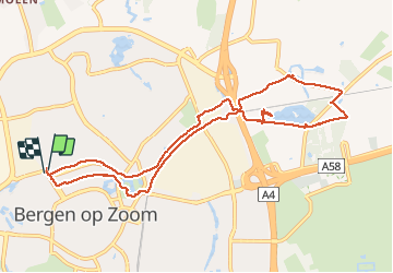
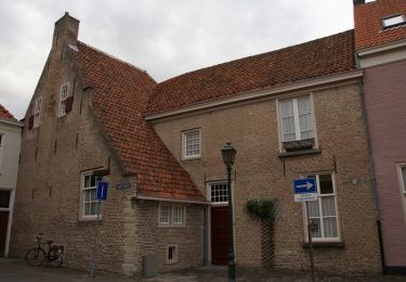
Randonnée Marche de 9,9 km à découvrir à Brabant-Septentrional, Inconnu, Berg-op-Zoom. Cette randonnée est proposée par Marc Ambagts.
Description
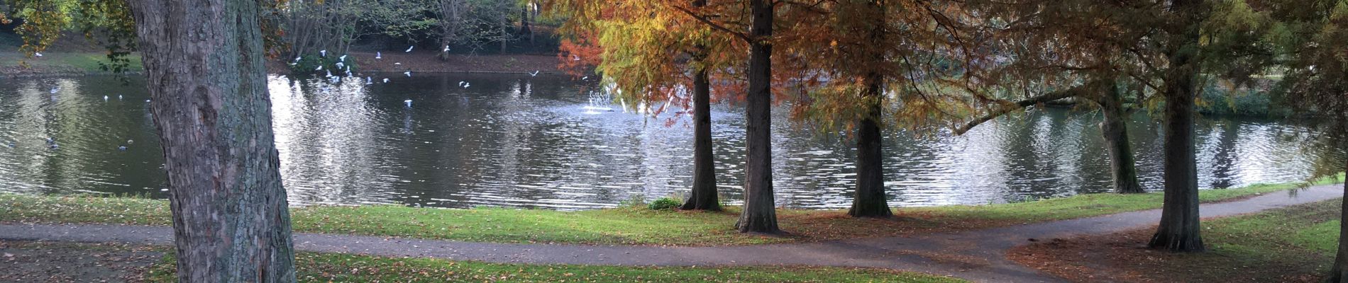
Een wandeling langs het riviertje de Zoom. Langs het meer van de Zanderijen en door het park van Bergen op Zoom weer terug.
Localisation
Pays :
Pays-Bas
Région :
Brabant-Septentrional
Département/Province :
Inconnu
Commune :
Berg-op-Zoom
Localité :
Unknown
Départ:(Dec)
Départ:(UTM)
588944 ; 5706225 (31U) N.
Commentaires
Randonnées à proximité
![Randonnée A pied Berg-op-Zoom - NS-wandeling De Roovere - Photo](https://media.geolcdn.com/t/375/260/99c1b283-f6ce-4214-973c-d8cf1b0a1324.jpeg&format=jpg&maxdim=2)
![A pied A pied](https://static1.geolcdn.com/sitytour/trail-icons/100.png)
NS-wandeling De Roovere
A pied
Facile
Berg-op-Zoom,
Brabant-Septentrional,
Inconnu,
Pays-Bas
![](/images/other/stat-length.png)
18,3 km | 20 km-effort
4h 32min
![](https://static1.geolcdn.com/siteimages/upload/files/16400158638029165_repeat_loop_refresh_sync_direction_icon.png)
Oui
![Randonnée Marche Berg-op-Zoom - GR12 Bergen op Zoom naar Kapellen - Photo](https://media.geolcdn.com/t/375/260/5f844581-7d5a-4995-bc35-e8d3d63fb285.jpg&format=jpg&maxdim=2)
![Marche Marche](https://static1.geolcdn.com/sitytour/trail-icons/101.png)
GR12 Bergen op Zoom naar Kapellen
Marche
Très difficile
Berg-op-Zoom,
Brabant-Septentrional,
Inconnu,
Pays-Bas
![](/images/other/stat-length.png)
42 km | 46 km-effort
7h 40min
![](https://static1.geolcdn.com/siteimages/upload/files/16400158638029165_repeat_loop_refresh_sync_direction_icon.png)
Non
![Randonnée Vélo Tholen - Zeeland - Markiezaatsroute - Photo](https://media.geolcdn.com/t/375/260/ext.jpg?maxdim=2&url=https%3A%2F%2Fstatic1.geolcdn.com%2Fsiteimages%2Fupload%2Ffiles%2F1524743154velo.jpg)
![Vélo Vélo](https://static1.geolcdn.com/sitytour/trail-icons/200.png)
Zeeland - Markiezaatsroute
Vélo
Très facile
Tholen,
Zélande,
Inconnu,
Pays-Bas
![](/images/other/stat-length.png)
55 km | 59 km-effort
Inconnu
![](https://static1.geolcdn.com/siteimages/upload/files/16400158638029165_repeat_loop_refresh_sync_direction_icon.png)
Oui
![Randonnée V.T.T. Berg-op-Zoom - m-nbrabant-rondje-heide - Photo](https://media.geolcdn.com/t/375/260/ext.jpg?maxdim=2&url=https%3A%2F%2Fstatic1.geolcdn.com%2Fsiteimages%2Fupload%2Ffiles%2F1524743154velo.jpg)
![V.T.T. V.T.T.](https://static1.geolcdn.com/sitytour/trail-icons/202.png)
m-nbrabant-rondje-heide
V.T.T.
Très facile
Berg-op-Zoom,
Brabant-Septentrional,
Inconnu,
Pays-Bas
![](/images/other/stat-length.png)
13,7 km | 15,1 km-effort
Inconnu
![](https://static1.geolcdn.com/siteimages/upload/files/16400158638029165_repeat_loop_refresh_sync_direction_icon.png)
Oui
![Randonnée V.T.T. Berg-op-Zoom - m-nbrabant-rondje-boslust - Photo](https://media.geolcdn.com/t/375/260/ext.jpg?maxdim=2&url=https%3A%2F%2Fstatic1.geolcdn.com%2Fsiteimages%2Fupload%2Ffiles%2F1524743154velo.jpg)
![V.T.T. V.T.T.](https://static1.geolcdn.com/sitytour/trail-icons/202.png)
m-nbrabant-rondje-boslust
V.T.T.
Très facile
Berg-op-Zoom,
Brabant-Septentrional,
Inconnu,
Pays-Bas
![](/images/other/stat-length.png)
15,7 km | 17,2 km-effort
Inconnu
![](https://static1.geolcdn.com/siteimages/upload/files/16400158638029165_repeat_loop_refresh_sync_direction_icon.png)
Oui
![Randonnée V.T.T. Berg-op-Zoom - m-nbrabant-bergse-plaat-wouwse-plantage - Photo](https://media.geolcdn.com/t/375/260/ext.jpg?maxdim=2&url=https%3A%2F%2Fstatic1.geolcdn.com%2Fsiteimages%2Fupload%2Ffiles%2F1524743154velo.jpg)
![V.T.T. V.T.T.](https://static1.geolcdn.com/sitytour/trail-icons/202.png)
m-nbrabant-bergse-plaat-wouwse-plantage
V.T.T.
Très facile
Berg-op-Zoom,
Brabant-Septentrional,
Inconnu,
Pays-Bas
![](/images/other/stat-length.png)
24 km | 27 km-effort
Inconnu
![](https://static1.geolcdn.com/siteimages/upload/files/16400158638029165_repeat_loop_refresh_sync_direction_icon.png)
Oui
![Randonnée Marche Berg-op-Zoom - w-nbrabant-zoomland - Photo](https://media.geolcdn.com/t/375/260/ext.jpg?maxdim=2&url=https%3A%2F%2Fstatic1.geolcdn.com%2Fsiteimages%2Fupload%2Ffiles%2F1553511878bg_sport_marche.png)
![Marche Marche](https://static1.geolcdn.com/sitytour/trail-icons/101.png)
w-nbrabant-zoomland
Marche
Très facile
Berg-op-Zoom,
Brabant-Septentrional,
Inconnu,
Pays-Bas
![](/images/other/stat-length.png)
9,5 km | 10,3 km-effort
Inconnu
![](https://static1.geolcdn.com/siteimages/upload/files/16400158638029165_repeat_loop_refresh_sync_direction_icon.png)
Oui
![Randonnée Marche Berg-op-Zoom - w-nbrabant-waawh-wouwse-plantage - Photo](https://media.geolcdn.com/t/375/260/ext.jpg?maxdim=2&url=https%3A%2F%2Fstatic1.geolcdn.com%2Fsiteimages%2Fupload%2Ffiles%2F1553511878bg_sport_marche.png)
![Marche Marche](https://static1.geolcdn.com/sitytour/trail-icons/101.png)
w-nbrabant-waawh-wouwse-plantage
Marche
Très facile
Berg-op-Zoom,
Brabant-Septentrional,
Inconnu,
Pays-Bas
![](/images/other/stat-length.png)
7,7 km | 8,6 km-effort
Inconnu
![](https://static1.geolcdn.com/siteimages/upload/files/16400158638029165_repeat_loop_refresh_sync_direction_icon.png)
Oui
![Randonnée Marche Berg-op-Zoom - w-nbrabant-rondom-bergen-op-zoom - Photo](https://media.geolcdn.com/t/375/260/ext.jpg?maxdim=2&url=https%3A%2F%2Fstatic1.geolcdn.com%2Fsiteimages%2Fupload%2Ffiles%2F1553511878bg_sport_marche.png)
![Marche Marche](https://static1.geolcdn.com/sitytour/trail-icons/101.png)
w-nbrabant-rondom-bergen-op-zoom
Marche
Très facile
Berg-op-Zoom,
Brabant-Septentrional,
Inconnu,
Pays-Bas
![](/images/other/stat-length.png)
28 km | 30 km-effort
Inconnu
![](https://static1.geolcdn.com/siteimages/upload/files/16400158638029165_repeat_loop_refresh_sync_direction_icon.png)
Oui