![](/images/other/stat-length.png)
![Randonnée Randonnée équestre Sainte-Consorce - boucle boisée - Photo](https://media.geolcdn.com/t/1900/400/ext.pjpeg?maxdim=2&url=https%3A%2F%2Fstatic1.geolcdn.com%2Fsiteimages%2Fupload%2Ffiles%2F1524743154cheval.jpg)
boucle boisée
c.decqcaillet
Utilisateur
![Longueur](/images/other/stat-length.png)
Longueur
7 km
![Altitude max](https://static1.geolcdn.com/siteimages/upload/files/1508320355ic_sort_altitude_max_24dp.png)
Altitude max
476 m
![Dénivelé positif](https://static1.geolcdn.com/siteimages/upload/files/1508320355ic_sort_den_pos_24dp.png)
Dénivelé positif
224 m
![Km-Effort](/images/other/stat-length.png)
Km-Effort
9,9 km
![Altitude min](https://static1.geolcdn.com/siteimages/upload/files/1508320355ic_sort_altitude_min_24dp.png)
Altitude min
317 m
![Dénivelé négatif](https://static1.geolcdn.com/siteimages/upload/files/1508320355ic_sort_den_neg_24dp.png)
Dénivelé négatif
199 m
![Boucle](https://static1.geolcdn.com/siteimages/upload/files/16400158638029165_repeat_loop_refresh_sync_direction_icon.png)
Boucle
Oui
Date de création :
2020-11-07 08:51:39.493
Dernière modification :
2020-11-07 10:09:42.8
![Randonnée équestre](https://static1.geolcdn.com/sitytour/trail-icons/301.png)
1h17
Difficulté : Très facile
![Scannez ce code QR pour ouvrir la randonnée dans l'application SityTrail](https://capi.geolives.com/qq0zvz2zws4bq2lad0pu/sitytour/trails/2595470/qr.png?size=200)
Application GPS de randonnée GRATUITE
À propos
Randonnée Randonnée équestre de 7 km à découvrir à Auvergne-Rhône-Alpes, Rhône, Sainte-Consorce. Cette randonnée est proposée par c.decqcaillet.
Description
peu de route, beaucoup de forêt
un peu de dénivelé, mais accessible à tous. deux zones de galop.
Localisation
Pays :
France
Région :
Auvergne-Rhône-Alpes
Département/Province :
Rhône
Commune :
Sainte-Consorce
Localité :
Unknown
Départ:(Dec)
Départ:(UTM)
630990 ; 5071350 (31T) N.
Commentaires
Randonnées à proximité
![Randonnée Marche Craponne - départ cimetière de Craponne - Photo](https://media.geolcdn.com/t/375/260/69d5a206-99fc-4c26-ba2a-07de4fc87322.jpg&format=jpg&maxdim=2)
![Marche Marche](https://static1.geolcdn.com/sitytour/trail-icons/101.png)
départ cimetière de Craponne
Marche
Facile
(1)
Craponne,
Auvergne-Rhône-Alpes,
Métropole de Lyon,
France
![](/images/other/stat-length.png)
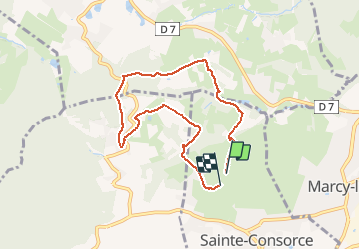
10,3 km | 13,1 km-effort
2h 36min
![](https://static1.geolcdn.com/siteimages/upload/files/16400158638029165_repeat_loop_refresh_sync_direction_icon.png)
Oui
![Randonnée Marche Pollionnay - Pollionnay, Croix du Ban, la Luère 7,5 Km - Photo](https://media.geolcdn.com/t/375/260/ext.jpg?maxdim=2&url=https%3A%2F%2Fservices.sitytrail.com%2FGeolivesWS%2FDownloadMedia.ashx%3FTrailID%3D104654%26Media%3D8048_4.jpg)
![Marche Marche](https://static1.geolcdn.com/sitytour/trail-icons/101.png)
Pollionnay, Croix du Ban, la Luère 7,5 Km
Marche
Moyen
(2)
Pollionnay,
Auvergne-Rhône-Alpes,
Rhône,
France
![](/images/other/stat-length.png)
7,3 km | 12 km-effort
2h 0min
![](https://static1.geolcdn.com/siteimages/upload/files/16400158638029165_repeat_loop_refresh_sync_direction_icon.png)
Oui
![Randonnée Marche Pollionnay - Pollionnay - Col de la Croix du Ban - Saint Bel - Photo](https://media.geolcdn.com/t/375/260/8ef9381a-0165-43ee-bec7-dd3c247c912c.jpg&format=jpg&maxdim=2)
![Marche Marche](https://static1.geolcdn.com/sitytour/trail-icons/101.png)
Pollionnay - Col de la Croix du Ban - Saint Bel
Marche
Très difficile
(1)
Pollionnay,
Auvergne-Rhône-Alpes,
Rhône,
France
![](/images/other/stat-length.png)
28 km | 40 km-effort
9h 9min
![](https://static1.geolcdn.com/siteimages/upload/files/16400158638029165_repeat_loop_refresh_sync_direction_icon.png)
Oui
![Randonnée Marche Lentilly - Santier des vaches LENTILLY - Photo](https://media.geolcdn.com/t/375/260/571590e7-6ce0-4ff1-b403-0f445cf01256.jpg&format=jpg&maxdim=2)
![Marche Marche](https://static1.geolcdn.com/sitytour/trail-icons/101.png)
Santier des vaches LENTILLY
Marche
Très facile
(1)
Lentilly,
Auvergne-Rhône-Alpes,
Rhône,
France
![](/images/other/stat-length.png)
3,2 km | 4,1 km-effort
51min
![](https://static1.geolcdn.com/siteimages/upload/files/16400158638029165_repeat_loop_refresh_sync_direction_icon.png)
Oui
![Randonnée Marche Vaugneray - Sur les hauteurs de Vaugneray - Photo](https://media.geolcdn.com/t/375/260/ext.jpg?maxdim=2&url=https%3A%2F%2Fservices.sitytrail.com%2FGeolivesWS%2FDownloadMedia.ashx%3FTrailID%3D106070%26Media%3D10246_2.jpg)
![Marche Marche](https://static1.geolcdn.com/sitytour/trail-icons/101.png)
Sur les hauteurs de Vaugneray
Marche
Moyen
(4)
Vaugneray,
Auvergne-Rhône-Alpes,
Rhône,
France
![](/images/other/stat-length.png)
12,5 km | 19,2 km-effort
4h 0min
![](https://static1.geolcdn.com/siteimages/upload/files/16400158638029165_repeat_loop_refresh_sync_direction_icon.png)
Oui
![Randonnée Marche Marcy-l'Étoile - 69 Marcy l'Etoile et les Monts du Lyonnais - Photo](https://media.geolcdn.com/t/375/260/ext.jpg?maxdim=2&url=https%3A%2F%2Fstatic1.geolcdn.com%2Fsiteimages%2Fupload%2Ffiles%2F1553511878bg_sport_marche.png)
![Marche Marche](https://static1.geolcdn.com/sitytour/trail-icons/101.png)
69 Marcy l'Etoile et les Monts du Lyonnais
Marche
Moyen
(1)
Marcy-l'Étoile,
Auvergne-Rhône-Alpes,
Métropole de Lyon,
France
![](/images/other/stat-length.png)
22 km | 30 km-effort
5h 0min
![](https://static1.geolcdn.com/siteimages/upload/files/16400158638029165_repeat_loop_refresh_sync_direction_icon.png)
Oui
![Randonnée Marche Saint-Pierre-la-Palud - Croix du ban - Col de la Luère - St Bonnet le froid - Photo](https://media.geolcdn.com/t/375/260/ext.jpg?maxdim=2&url=https%3A%2F%2Fstatic1.geolcdn.com%2Fsiteimages%2Fupload%2Ffiles%2F1553511878bg_sport_marche.png)
![Marche Marche](https://static1.geolcdn.com/sitytour/trail-icons/101.png)
Croix du ban - Col de la Luère - St Bonnet le froid
Marche
Difficile
(3)
Saint-Pierre-la-Palud,
Auvergne-Rhône-Alpes,
Rhône,
France
![](/images/other/stat-length.png)
9,6 km | 14,3 km-effort
3h 15min
![](https://static1.geolcdn.com/siteimages/upload/files/16400158638029165_repeat_loop_refresh_sync_direction_icon.png)
Oui
![Randonnée Marche Vaugneray - Vaugneray - Lac D'Yseron- Parc Animalier de Courzieu - Photo](https://media.geolcdn.com/t/375/260/562e06b9-621d-475c-8be3-41f24f4bbed6.jpg&format=jpg&maxdim=2)
![Marche Marche](https://static1.geolcdn.com/sitytour/trail-icons/101.png)
Vaugneray - Lac D'Yseron- Parc Animalier de Courzieu
Marche
Très difficile
(1)
Vaugneray,
Auvergne-Rhône-Alpes,
Rhône,
France
![](/images/other/stat-length.png)
38 km | 58 km-effort
13h 13min
![](https://static1.geolcdn.com/siteimages/upload/files/16400158638029165_repeat_loop_refresh_sync_direction_icon.png)
Oui
![Randonnée Randonnée équestre Sainte-Consorce - Balade en forêt - Photo](https://media.geolcdn.com/t/375/260/ext.jpg?maxdim=2&url=https%3A%2F%2Fstatic1.geolcdn.com%2Fsiteimages%2Fupload%2Ffiles%2F1524743154cheval.jpg)
![Randonnée équestre Randonnée équestre](https://static1.geolcdn.com/sitytour/trail-icons/301.png)
Balade en forêt
Randonnée équestre
Facile
(1)
Sainte-Consorce,
Auvergne-Rhône-Alpes,
Rhône,
France
![](/images/other/stat-length.png)
6,5 km | 8,8 km-effort
1h 17min
![](https://static1.geolcdn.com/siteimages/upload/files/16400158638029165_repeat_loop_refresh_sync_direction_icon.png)
Oui