![](/images/other/stat-length.png)
![Randonnée Marche Wommelghem - langs vier gemeenten - Photo](https://media.geolcdn.com/t/1900/400/ext.pjpeg?maxdim=2&url=https%3A%2F%2Fstatic1.geolcdn.com%2Fsiteimages%2Fupload%2Ffiles%2F1553511878bg_sport_marche.png)
langs vier gemeenten
stafnoel
Utilisateur
![Longueur](/images/other/stat-length.png)
Longueur
14,7 km
![Altitude max](https://static1.geolcdn.com/siteimages/upload/files/1508320355ic_sort_altitude_max_24dp.png)
Altitude max
19 m
![Dénivelé positif](https://static1.geolcdn.com/siteimages/upload/files/1508320355ic_sort_den_pos_24dp.png)
Dénivelé positif
113 m
![Km-Effort](/images/other/stat-length.png)
Km-Effort
16,2 km
![Altitude min](https://static1.geolcdn.com/siteimages/upload/files/1508320355ic_sort_altitude_min_24dp.png)
Altitude min
-2 m
![Dénivelé négatif](https://static1.geolcdn.com/siteimages/upload/files/1508320355ic_sort_den_neg_24dp.png)
Dénivelé négatif
113 m
![Boucle](https://static1.geolcdn.com/siteimages/upload/files/16400158638029165_repeat_loop_refresh_sync_direction_icon.png)
Boucle
Oui
Date de création :
2014-12-10 00:00:00.0
Dernière modification :
2014-12-10 00:00:00.0
![Marche](https://static1.geolcdn.com/sitytour/trail-icons/101.png)
3h13
Difficulté : Facile
![Scannez ce code QR pour ouvrir la randonnée dans l'application SityTrail](https://capi.geolives.com/qq0zvz2zws4bq2lad0pu/sitytour/trails/259255/qr.png?size=200)
Application GPS de randonnée GRATUITE
À propos
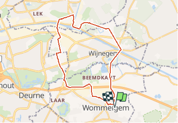
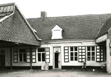
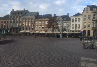
Randonnée Marche de 14,7 km à découvrir à Flandre, Anvers, Wommelghem. Cette randonnée est proposée par stafnoel.
Description
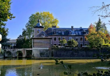
Opgelet: na brug Wijnegem een stukje privé-eigendom, links van wijngaarden, de Houtlaan over, dan links van de kasteelgracht het bos doorsteken
Localisation
Pays :
Belgique
Région :
Flandre
Département/Province :
Anvers
Commune :
Wommelghem
Localité :
Wommelgem
Départ:(Dec)
Départ:(UTM)
606898 ; 5673528 (31U) N.
Commentaires
Randonnées à proximité
![Randonnée A pied Ranst - Zevenbergenpad - Photo](https://media.geolcdn.com/t/375/260/c3e3f875-0d2e-46ea-9890-6b19a27bb037.jpeg&format=jpg&maxdim=2)
![A pied A pied](https://static1.geolcdn.com/sitytour/trail-icons/100.png)
![Randonnée A pied Anvers - Rode paaltjes - Photo](https://media.geolcdn.com/t/375/260/002b9139-fff4-4587-a2ae-858ec5066b90.jpeg&format=jpg&maxdim=2)
![A pied A pied](https://static1.geolcdn.com/sitytour/trail-icons/100.png)
![Randonnée A pied Wommelghem - Withofwandelpad - Photo](https://media.geolcdn.com/t/375/260/50c213db-98ac-4089-83d4-e17d921cd8cd.jpeg&format=jpg&maxdim=2)
![A pied A pied](https://static1.geolcdn.com/sitytour/trail-icons/100.png)
Withofwandelpad
A pied
Facile
Wommelghem,
Flandre,
Anvers,
Belgique
![](/images/other/stat-length.png)
11,2 km | 11,8 km-effort
2h 40min
![](https://static1.geolcdn.com/siteimages/upload/files/16400158638029165_repeat_loop_refresh_sync_direction_icon.png)
Oui
![Randonnée A pied Wommelghem - Roosehofwandelpad - Photo](https://media.geolcdn.com/t/375/260/7d6df0f5-deda-40e4-8ef0-77104cb1a6a9.jpeg&format=jpg&maxdim=2)
![A pied A pied](https://static1.geolcdn.com/sitytour/trail-icons/100.png)
Roosehofwandelpad
A pied
Facile
Wommelghem,
Flandre,
Anvers,
Belgique
![](/images/other/stat-length.png)
4,8 km | 5,1 km-effort
1h 9min
![](https://static1.geolcdn.com/siteimages/upload/files/16400158638029165_repeat_loop_refresh_sync_direction_icon.png)
Non
![Randonnée A pied Boechout - Jef Van Hoofpad - Photo](https://media.geolcdn.com/t/375/260/da67258e-7d0f-486b-9452-0c6a3dbd4fa3.jpeg&format=jpg&maxdim=2)
![A pied A pied](https://static1.geolcdn.com/sitytour/trail-icons/100.png)
![Randonnée Marche Wijnegem - Wijnegem 2012/05 - Photo](https://media.geolcdn.com/t/375/260/ext.jpg?maxdim=2&url=https%3A%2F%2Fstatic1.geolcdn.com%2Fsiteimages%2Fupload%2Ffiles%2F1553511878bg_sport_marche.png)
![Marche Marche](https://static1.geolcdn.com/sitytour/trail-icons/101.png)
Wijnegem 2012/05
Marche
Très facile
(1)
Wijnegem,
Flandre,
Anvers,
Belgique
![](/images/other/stat-length.png)
1,9 km | 2 km-effort
27min
![](https://static1.geolcdn.com/siteimages/upload/files/16400158638029165_repeat_loop_refresh_sync_direction_icon.png)
Oui
![Randonnée Marche Boechout - 64.425 Boechout - Duffel - Photo](https://media.geolcdn.com/t/375/260/03af4d1b-ee76-4d87-a836-6091a7672080.jpg&format=jpg&maxdim=2)
![Marche Marche](https://static1.geolcdn.com/sitytour/trail-icons/101.png)
64.425 Boechout - Duffel
Marche
(1)
Boechout,
Flandre,
Anvers,
Belgique
![](/images/other/stat-length.png)
20 km | 22 km-effort
5h 19min
![](https://static1.geolcdn.com/siteimages/upload/files/16400158638029165_repeat_loop_refresh_sync_direction_icon.png)
Non
![Randonnée Vélo Ranst - f-belgie-kastelenroute - Photo](https://media.geolcdn.com/t/375/260/ext.jpg?maxdim=2&url=https%3A%2F%2Fstatic1.geolcdn.com%2Fsiteimages%2Fupload%2Ffiles%2F1524743154velo.jpg)
![Vélo Vélo](https://static1.geolcdn.com/sitytour/trail-icons/200.png)
f-belgie-kastelenroute
Vélo
Très facile
Ranst,
Flandre,
Anvers,
Belgique
![](/images/other/stat-length.png)
42 km | 46 km-effort
Inconnu
![](https://static1.geolcdn.com/siteimages/upload/files/16400158638029165_repeat_loop_refresh_sync_direction_icon.png)
Oui
![Randonnée Vélo Ranst - f-belgie-dwars-door-het-land-van-playsatien - Photo](https://media.geolcdn.com/t/375/260/ext.jpg?maxdim=2&url=https%3A%2F%2Fstatic1.geolcdn.com%2Fsiteimages%2Fupload%2Ffiles%2F1524743154velo.jpg)
![Vélo Vélo](https://static1.geolcdn.com/sitytour/trail-icons/200.png)
f-belgie-dwars-door-het-land-van-playsatien
Vélo
Très facile
Ranst,
Flandre,
Anvers,
Belgique
![](/images/other/stat-length.png)
74 km | 80 km-effort
Inconnu
![](https://static1.geolcdn.com/siteimages/upload/files/16400158638029165_repeat_loop_refresh_sync_direction_icon.png)
Oui