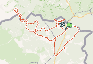
![](/images/other/stat-length.png)
![Randonnée A pied Bullange - Vallée de la Schwalm - Photo](https://media.geolcdn.com/t/1900/400/ext.pjpeg?maxdim=2&url=https%3A%2F%2Fstatic1.geolcdn.com%2Fsiteimages%2Fupload%2Ffiles%2F1545311037marcheuse_200dpi.jpg)
Vallée de la Schwalm
MathieuBourgois
Utilisateur
![Longueur](/images/other/stat-length.png)
![Altitude max](https://static1.geolcdn.com/siteimages/upload/files/1508320355ic_sort_altitude_max_24dp.png)
![Dénivelé positif](https://static1.geolcdn.com/siteimages/upload/files/1508320355ic_sort_den_pos_24dp.png)
![Km-Effort](/images/other/stat-length.png)
![Altitude min](https://static1.geolcdn.com/siteimages/upload/files/1508320355ic_sort_altitude_min_24dp.png)
![Dénivelé négatif](https://static1.geolcdn.com/siteimages/upload/files/1508320355ic_sort_den_neg_24dp.png)
![Boucle](https://static1.geolcdn.com/siteimages/upload/files/16400158638029165_repeat_loop_refresh_sync_direction_icon.png)
![A pied](https://static1.geolcdn.com/sitytour/trail-icons/100.png)
--
Difficulté : Très facile
![Scannez ce code QR pour ouvrir la randonnée dans l'application SityTrail](https://capi.geolives.com/qq0zvz2zws4bq2lad0pu/sitytour/trails/2588244/qr.png?size=200)
Application GPS de randonnée GRATUITE
À propos
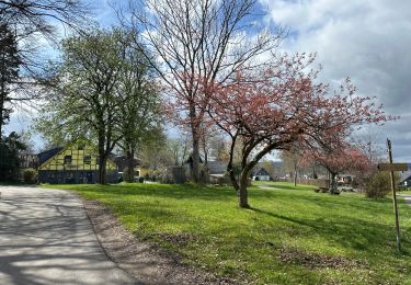
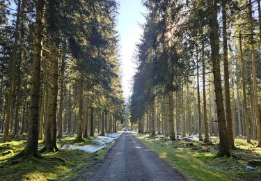
Randonnée A pied de 27 km à découvrir à Wallonie, Liège, Bullange. Cette randonnée est proposée par MathieuBourgois.
Description
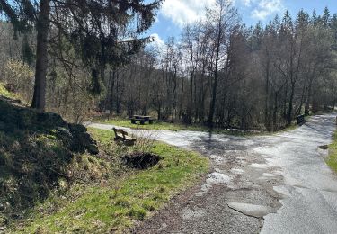
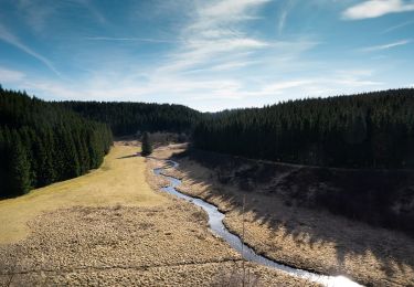
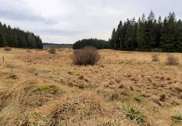
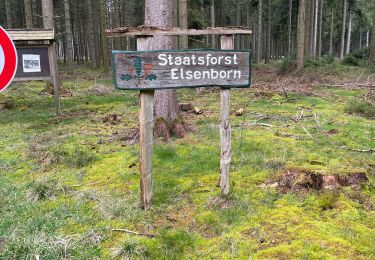
Cette vallée, tributaire de la Rur, est située à l'est du camp militaire d'Elsenborn, donc en Haute-Ardenne. Elle renferme une grande diversité de milieux ainsi que de nombreuses espèces végétales et animales dites 'boréo-montagnardes', ce qui a largement justifié son classement en réserve naturelle domaniale. On y trouve des tourbières basses, des jonchaies acutiflores, des nardaies à arnica, des landes à callunes et myrtilles, des prés à fenouil des Alpes, etc. Parmi la faune, très riche, de cette vallée, figurent divers éléments typiques des massifs montagneux.
Localisation
Commentaires
Randonnées à proximité
![Randonnée Marche Montjoie - Route des jonquilles Monschau-Höfen - Photo](https://media.geolcdn.com/t/375/260/f78b6422-c27b-477b-b695-82eecbd61b40.jpg&format=jpg&maxdim=2)
![Marche Marche](https://static1.geolcdn.com/sitytour/trail-icons/101.png)
Marche
![](/images/other/stat-length.png)
![](https://static1.geolcdn.com/siteimages/upload/files/16400158638029165_repeat_loop_refresh_sync_direction_icon.png)
![Randonnée Marche Montjoie - Rando Eifel des jonquilles narcisses 18,3 - Photo](https://media.geolcdn.com/t/375/260/29cf751c-7851-449b-b365-4b88ea56faf3.jpg&format=jpg&maxdim=2)
![Marche Marche](https://static1.geolcdn.com/sitytour/trail-icons/101.png)
Marche
![](/images/other/stat-length.png)
![](https://static1.geolcdn.com/siteimages/upload/files/16400158638029165_repeat_loop_refresh_sync_direction_icon.png)
![Randonnée A pied Montjoie - Narzissenroute Höfen (Eifel) - Photo](https://media.geolcdn.com/t/375/260/4209bd6d-0e5a-4c94-aa91-ecdefe50dbb3.jpeg&format=jpg&maxdim=2)
![A pied A pied](https://static1.geolcdn.com/sitytour/trail-icons/100.png)
A pied
![](/images/other/stat-length.png)
![](https://static1.geolcdn.com/siteimages/upload/files/16400158638029165_repeat_loop_refresh_sync_direction_icon.png)
![Randonnée Marche Montjoie - Höfen variante narcisses 15,3 km - Photo](https://media.geolcdn.com/t/375/260/8f102c28-a86b-453b-9287-1c0a4daafc7c.jpg&format=jpg&maxdim=2)
![Marche Marche](https://static1.geolcdn.com/sitytour/trail-icons/101.png)
Marche
![](/images/other/stat-length.png)
![](https://static1.geolcdn.com/siteimages/upload/files/16400158638029165_repeat_loop_refresh_sync_direction_icon.png)
![Randonnée Marche Bullange - Rocher du Bieley - Photo](https://media.geolcdn.com/t/375/260/669e4f82-1f7b-41ec-94b2-f43792433cc6.jpg&format=jpg&maxdim=2)
![Marche Marche](https://static1.geolcdn.com/sitytour/trail-icons/101.png)
Marche
![](/images/other/stat-length.png)
![](https://static1.geolcdn.com/siteimages/upload/files/16400158638029165_repeat_loop_refresh_sync_direction_icon.png)
![Randonnée Marche Bullange - La vallée perdue - Rocherath - Photo](https://media.geolcdn.com/t/375/260/5033c82c-f26d-4ed7-b97f-52628b611391.jpg&format=jpg&maxdim=2)
![Marche Marche](https://static1.geolcdn.com/sitytour/trail-icons/101.png)
Marche
![](/images/other/stat-length.png)
![](https://static1.geolcdn.com/siteimages/upload/files/16400158638029165_repeat_loop_refresh_sync_direction_icon.png)
![Randonnée Marche Bullange - Vallée de la Schwalme - Photo](https://media.geolcdn.com/t/375/260/add47439-0f30-4a61-b2b5-c8833884d925.jpg&format=jpg&maxdim=2)
![Marche Marche](https://static1.geolcdn.com/sitytour/trail-icons/101.png)
Marche
![](/images/other/stat-length.png)
![](https://static1.geolcdn.com/siteimages/upload/files/16400158638029165_repeat_loop_refresh_sync_direction_icon.png)
![Randonnée Marche Bullange - A la découverte de Elsenborn 🥾 - Photo](https://media.geolcdn.com/t/375/260/4ebad11f-f525-4a2f-bf6a-69abd51f6991.jpg&format=jpg&maxdim=2)
![Marche Marche](https://static1.geolcdn.com/sitytour/trail-icons/101.png)
Marche
![](/images/other/stat-length.png)
![](https://static1.geolcdn.com/siteimages/upload/files/16400158638029165_repeat_loop_refresh_sync_direction_icon.png)
![Randonnée Marche Bullange - Rocherath (Rocher de Bieley) 12 Km - Photo](https://media.geolcdn.com/t/375/260/aa0f5249-fd94-48f9-88c8-1ed2c140fa37.jpg&format=jpg&maxdim=2)
![Marche Marche](https://static1.geolcdn.com/sitytour/trail-icons/101.png)
Marche
![](/images/other/stat-length.png)
![](https://static1.geolcdn.com/siteimages/upload/files/16400158638029165_repeat_loop_refresh_sync_direction_icon.png)