![](/images/other/stat-length.png)
![Randonnée Marche Saint-Philippe - La Réunion - Boucle par le bord de mer de Basse Vallée (secteur St Philippe) - Photo](https://media.geolcdn.com/t/1900/400/ext.pjpeg?maxdim=2&url=https%3A%2F%2Fservices.sitytrail.com%2FGeolivesWS%2FDownloadMedia.ashx%3FTrailID%3D258813%26Media%3Dfix__20140320160717.jpg)
La Réunion - Boucle par le bord de mer de Basse Vallée (secteur St Philippe)
olive2b
Utilisateur
![Longueur](/images/other/stat-length.png)
Longueur
2,4 km
![Altitude max](https://static1.geolcdn.com/siteimages/upload/files/1508320355ic_sort_altitude_max_24dp.png)
Altitude max
41 m
![Dénivelé positif](https://static1.geolcdn.com/siteimages/upload/files/1508320355ic_sort_den_pos_24dp.png)
Dénivelé positif
37 m
![Km-Effort](/images/other/stat-length.png)
Km-Effort
2,9 km
![Altitude min](https://static1.geolcdn.com/siteimages/upload/files/1508320355ic_sort_altitude_min_24dp.png)
Altitude min
8 m
![Dénivelé négatif](https://static1.geolcdn.com/siteimages/upload/files/1508320355ic_sort_den_neg_24dp.png)
Dénivelé négatif
34 m
![Boucle](https://static1.geolcdn.com/siteimages/upload/files/16400158638029165_repeat_loop_refresh_sync_direction_icon.png)
Boucle
Oui
Date de création :
2016-03-09 00:00:00.0
Dernière modification :
2016-03-09 00:00:00.0
![Marche](https://static1.geolcdn.com/sitytour/trail-icons/101.png)
1h02
Difficulté : Inconnu
![Scannez ce code QR pour ouvrir la randonnée dans l'application SityTrail](https://capi.geolives.com/qq0zvz2zws4bq2lad0pu/sitytour/trails/258813/qr.png?size=200)
Application GPS de randonnée GRATUITE
À propos
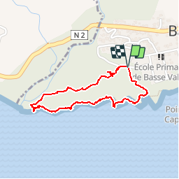
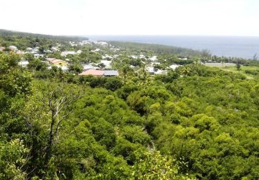
Randonnée Marche de 2,4 km à découvrir à La Réunion, Inconnu, Saint-Philippe. Cette randonnée est proposée par olive2b.
Description
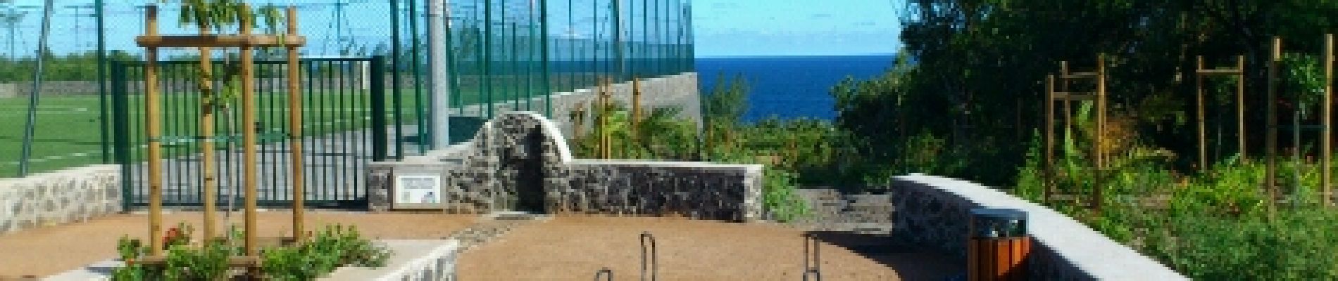
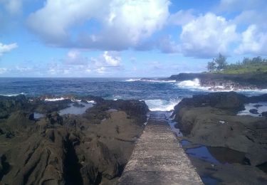
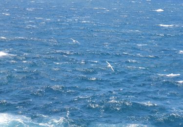
Le départ se fait sur la droite du stade de foot. Balade sympa d'une petite heure pour observer le bord de mer, avec ses falaises, ses vagues se cassant sur la roche. On peut la prolonger en passant par le Cap Méchant à l'Est.
Localisation
Pays :
France
Région :
La Réunion
Département/Province :
Inconnu
Commune :
Saint-Philippe
Localité :
Unknown
Départ:(Dec)
Départ:(UTM)
365974 ; 7635890 (40K) S.
Commentaires
Randonnées à proximité
![Randonnée Marche Saint-Joseph - Cap Jaune randonnée famille - Photo](https://media.geolcdn.com/t/375/260/0eb20c45-f963-4b69-a85f-83e3bdaa6b80.jpg&format=jpg&maxdim=2)
![Marche Marche](https://static1.geolcdn.com/sitytour/trail-icons/101.png)
Cap Jaune randonnée famille
Marche
Très facile
Saint-Joseph,
La Réunion,
Inconnu,
France
![](/images/other/stat-length.png)
3,3 km | 4,4 km-effort
2h 0min
![](https://static1.geolcdn.com/siteimages/upload/files/16400158638029165_repeat_loop_refresh_sync_direction_icon.png)
Oui
![Randonnée Marche Saint-Philippe - sentiers botaniques - Photo](https://media.geolcdn.com/t/375/260/ext.jpg?maxdim=2&url=https%3A%2F%2Fservices.sitytrail.com%2FGeolivesWS%2FDownloadMedia.ashx%3FTrailID%3D232114%26Media%3Dfix__20131111125801.jpg)
![Marche Marche](https://static1.geolcdn.com/sitytour/trail-icons/101.png)
sentiers botaniques
Marche
Très facile
Saint-Philippe,
La Réunion,
Inconnu,
France
![](/images/other/stat-length.png)
4,2 km | 6,5 km-effort
1h 50min
![](https://static1.geolcdn.com/siteimages/upload/files/16400158638029165_repeat_loop_refresh_sync_direction_icon.png)
Oui
![Randonnée Marche Saint-Joseph - cap jaune - Photo](https://media.geolcdn.com/t/375/260/b1bf09be-09a9-4227-9178-69439bebcf69.jpg&format=jpg&maxdim=2)
![Marche Marche](https://static1.geolcdn.com/sitytour/trail-icons/101.png)
cap jaune
Marche
Très facile
Saint-Joseph,
La Réunion,
Inconnu,
France
![](/images/other/stat-length.png)
4,9 km | 6,6 km-effort
1h 18min
![](https://static1.geolcdn.com/siteimages/upload/files/16400158638029165_repeat_loop_refresh_sync_direction_icon.png)
Oui
![Randonnée Marche Saint-Philippe - GR® R2 Du gîte de Basse Vallée à Basse Vallée - Photo](https://media.geolcdn.com/t/375/260/ext.jpg?maxdim=2&url=https%3A%2F%2Fservices.sitytrail.com%2FGeolivesWS%2FDownloadMedia.ashx%3FTrailID%3D316702%26Media%3D3859_1.jpg)
![Marche Marche](https://static1.geolcdn.com/sitytour/trail-icons/101.png)
GR® R2 Du gîte de Basse Vallée à Basse Vallée
Marche
Moyen
Saint-Philippe,
La Réunion,
Inconnu,
France
![](/images/other/stat-length.png)
5 km | 6,9 km-effort
2h 0min
![](https://static1.geolcdn.com/siteimages/upload/files/16400158638029165_repeat_loop_refresh_sync_direction_icon.png)
Non
![Randonnée Marche Saint-Philippe - La Réunion - Boucle par le sentier botanique de la forêt de Mare-Longue - Photo](https://media.geolcdn.com/t/375/260/ext.jpg?maxdim=2&url=https%3A%2F%2Fservices.sitytrail.com%2FGeolivesWS%2FDownloadMedia.ashx%3FTrailID%3D255672%26Media%3Dfix__20140309142644.jpg)
![Marche Marche](https://static1.geolcdn.com/sitytour/trail-icons/101.png)
La Réunion - Boucle par le sentier botanique de la forêt de Mare-Longue
Marche
Très facile
Saint-Philippe,
La Réunion,
Inconnu,
France
![](/images/other/stat-length.png)
2,4 km | 3,8 km-effort
1h 29min
![](https://static1.geolcdn.com/siteimages/upload/files/16400158638029165_repeat_loop_refresh_sync_direction_icon.png)
Oui
![Randonnée Marche Saint-Joseph - A/R Terre rouge, Le récif - Photo](https://media.geolcdn.com/t/375/260/ext.jpg?maxdim=2&url=https%3A%2F%2Fstatic1.geolcdn.com%2Fsiteimages%2Fupload%2Ffiles%2F1553511878bg_sport_marche.png)
![Marche Marche](https://static1.geolcdn.com/sitytour/trail-icons/101.png)
A/R Terre rouge, Le récif
Marche
Très facile
Saint-Joseph,
La Réunion,
Inconnu,
France
![](/images/other/stat-length.png)
5 km | 6,8 km-effort
1h 33min
![](https://static1.geolcdn.com/siteimages/upload/files/16400158638029165_repeat_loop_refresh_sync_direction_icon.png)
Oui
![Randonnée Marche Saint-Philippe - vallée heureuse - Photo](https://media.geolcdn.com/t/375/260/ext.jpg?maxdim=2&url=https%3A%2F%2Fstatic1.geolcdn.com%2Fsiteimages%2Fupload%2Ffiles%2F1553511878bg_sport_marche.png)
![Marche Marche](https://static1.geolcdn.com/sitytour/trail-icons/101.png)
vallée heureuse
Marche
Difficile
Saint-Philippe,
La Réunion,
Inconnu,
France
![](/images/other/stat-length.png)
21 km | 44 km-effort
8h 49min
![](https://static1.geolcdn.com/siteimages/upload/files/16400158638029165_repeat_loop_refresh_sync_direction_icon.png)
Oui
![Randonnée Marche Saint-Joseph - piton vincendo - cap poisson d'ail - Photo](https://media.geolcdn.com/t/375/260/ext.jpg?maxdim=2&url=https%3A%2F%2Fstatic1.geolcdn.com%2Fsiteimages%2Fupload%2Ffiles%2F1553511878bg_sport_marche.png)
![Marche Marche](https://static1.geolcdn.com/sitytour/trail-icons/101.png)
piton vincendo - cap poisson d'ail
Marche
Facile
Saint-Joseph,
La Réunion,
Inconnu,
France
![](/images/other/stat-length.png)
5,3 km | 7,2 km-effort
1h 30min
![](https://static1.geolcdn.com/siteimages/upload/files/16400158638029165_repeat_loop_refresh_sync_direction_icon.png)
Oui
![Randonnée sport Saint-Philippe - 2024-10-12_17h15m34_Randopitons Itineraire #1328 - Sentier Botanique Mare Longue Saint Philippe - Photo](https://media.geolcdn.com/t/375/260/ext.jpg?maxdim=2&url=https%3A%2F%2Fsecurestorage.geolives.com%2Fsitytour%2Ftrail-bg%2Fdefault.jpg)
2024-10-12_17h15m34_Randopitons Itineraire #1328 - Sentier Botanique Mare Lon...
sport
Très facile
Saint-Philippe,
La Réunion,
Inconnu,
France
![](/images/other/stat-length.png)
4,2 km | 6,8 km-effort
Inconnu
![](https://static1.geolcdn.com/siteimages/upload/files/16400158638029165_repeat_loop_refresh_sync_direction_icon.png)
Oui